2
What is Geography anyway?
Beware: geography is NOT the same as geology. These are related disciplines for sure, but there is a very important distinction between the two and we don’t have to look far to learn what that is (hint: Greek roots! Yep, locate them in your brain).
Geography: geo + graphy = to write the world
Geology: geo + logy = to study the world
In one sense, geography can certainly be understood as the study of the world, however, first and foremost, the discipline is about writing the world.
What does it mean to “write the world”? It means to chart the land, the sea, and the sky; to describe the natural and socio-cultural processes and systems of which humans and animals are part; to represent the world.
How can we “write the world”? Geographers can write travel journals and observations about people and place; measure distance between physical features; map place at the local, regional, and international scales.
Branches of Geography
Geography as an academic discipline and practice can be divided into a few main branches, namely: human geography, physical geography, human-environment geography, and Geoinformation Science (GIScience), sometimes called Mapping Sciences.
Geographic Tools & Methods
Scientific research is oriented around gathering data and producing useful knowledge. Data and methods can be qualitative, quantitative, or a mix of the two. Qualitative data and methods rely on information derived from words; quantitative data and methods rely on information derived from numbers.
In terms of geography, data collection methods such as observation, surveys, and interviews tend to be more qualitative, whereas specimen sampling, mapping, and remote sensing tend to be more quantitative. However, there is a fair deal of overlap between the two genres of data and research methods, so don’t get too bogged down trying to differentiate the two.
Let’s take a closer look at some key geographic tools and methods. Remember, regardless of the method, geographers rely on a spatial perspective to answer “What is where, why there, and why care?” (Gritzner, 2000) in order to produce useful geographic knowledge.
Maps
Mapping is a way to “write the world” and therefore is a kind of representation. The art and science of creating maps is known as cartography. With cartographic representation, especially with trying to represent a 3-D earth on a 2-D surface, comes distortion. This distortion actually shapes our geographical knowledge of the world and affects our perceptions of place. For instance, if you’ve ever played the board-game Risk where Greenland looked huge compared to Africa, or grew up with a map of the United States that placed Hawai` i just off the coast of California, you know what I’m talking about.
Learn more about map projections and distortions in the video below.
Labeling maps and adding toponyms (names of places) is also a representative practice, and reminds us of the power involved in the act of representing.
Check out the image below for a map of Hawai` i from 1901 commissioned by the Hawaii Territory Survey, after the end of the Hawaiian Kingdom and soon after American occupation began. You’ll see the labels “no vegetation, waste land” towards the center. The map shows Mauna Kea, an inactive volcano on the Big Island.
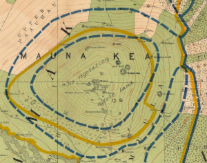
These labels assign meaning to the area mapped here from the mapmaker’s perspective, but do not necessarily reflect the meaning the land has for others. For instance, Mauna Kea is a sacred and culturally significant site quite the opposite of waste land for many Hawaiians, particularly Native Hawaiian cultural practitioners. This example underscores the power that comes in mapping and naming and how it can equally highlight and obscure features and meaning of places.
Colonial era maps often used used label terra nullius, a Latin term meaning nobody’s land or empty land. Maps with this label played a role in justifying colonialism, as colonizers used the supposed-reality, as marked on a reliable map, that land was unoccupied and therefore up for grabs. Labels like this ignore and silence the presence of indigenous people and meanings of land help by non-mapmakers.
Maps have power. Historically, maps were created for and by those with political power. Maps were used to demarcate and claim ownership of land; a means of showing everyone that one has planted their proverbial flag to claim possession. As such, maps have an air of authority and being “official” and “true.” But all maps are made for specific purposes, and can have both accidental and purposeful lies included. The accidental, small white lies of a map have to do most often with the creation of a representation and generalization. Maps have scale, and will show a larger geographic area than the size of the paper they are printed upon. Because the map is not at a 1:1 scale as the world, objects must be simplified or generalized in order to not be overly cluttered by the infinite complexity of the world. What is shown, and just as importantly not shown, are choices made by the cartographer. A map might show the locations of important socioeconomic features, like schools and mines, but not show features like landfills or prisons.
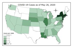
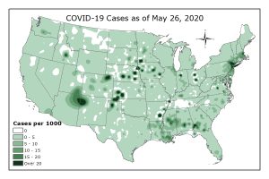
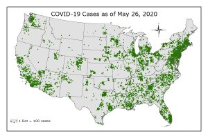
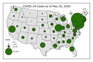
Two broad categories of maps exist. General reference (or general purpose) maps are those that show important physical or cultural features in an area. Thematic maps are those that shows information about a particular topic. Thematic maps use qualitative and quantitative data to show spatial patterns. Several types of thematic maps exist, differentiated in how thematic data is displayed. Choropleth, isoline, dot density, and proportional / graduated symbols are all examples of thematic maps.
Examples of thematic maps
The following maps show four types of thematic maps using the same data.
(Data from Census Bureau and the Centers for Disease Control and Prevention; maps by author)
GIS (Geographic Information Systems)
GIS stands for Geographic Information Systems and is foundational to Geoinformation Science (GIScience). What is it? It’s a technically advanced way of making in-depth maps by layering together data. Imagine a double-decker peanut butter and jelly sandwich, but instead of the traditional ingredients, the layers are:
- groundcover
- streams
- streets
- above-ground electrical lines
- infrastructure
Now smash all those layers together like a good sandwich and you have replicated in a very rudimentary way how GIS creates a composite view of place.
Remote Sensing
When you cannot be in a particular place and collect data on the ground, you can collect it from above ground by using remote sensing technologies. Remote sensing refers to collecting data from afar. This is typically achieved through cameras, videos, and sensors attached to aircraft including airplanes, satellites, and drones.
Remote sensing provides a wonderful way to gather information about the Earth’s surface and allows us to track landscape change over time.
Exercise: Identifying Landscape Change
Peruse the before and after landscape changes profiled in these USGS Earthshots cards.
Learn more about what geoinformation technologies can do in practice in the video below.
Qualitative analysis of interviews, surveys, and texts
This is human geography, after all, so we definitely don’t want to forget that people themselves have a lot to teach us about the world and their words, stories, and experiences certainly help geographers answer “What is where, why there, and why care?” (Gritzner, 2000).
What might a geographer use?
- Interviews where a researcher asks either a set of closed (yes/no, etc) or open-ended (no answer choices given) questions
- Surveys where a researcher sends a questionnaire to a set of people to learn about their experience or perception of the phenomenon being studied
- Texts where a researcher may review old maps and documents in an archive, environmental impact statements outlining the existing natural and cultural resources of an area, etc.
The data collected is qualitative in nature, meaning it is based around words. Once the stories and experiences of place-based research questions are gathered, the researcher will analyze them by categorizing the data across all sources into themes and even quantify the relative presence of the themes in comparison to each other.
To build upon the example above of a map that coded indigenous land as terra nullius, you can imagine how talking to indigenous people about their own perceptions of that place and the values and meanings that the land has for them, would significantly add to our overall geographical knowledge and understanding of the world. It would also have implications for policies on how to manage the land.
Media Attributions
- Screen Shot 2020-05-25 at 2.57.29 PM
- choropleth
- isoline
- dotdensity
- propsym
to write the world
to study the world
branch of geography
branch of geography
branch of geography that studies relationships between humans and environment
branch of geography that uses computer programs to represent various geographical processes
relies on words
relies on numbers
way of representing the word
art and science of creating maps
names of places
a Latin term meaning nobody's land or empty land
sweeping, not entirely specific
ratio of distance on map to distance on ground
maps are those that show important physical or cultural features in an area
shows information about a particular topic
shows values through color/tint/shading existing political/administrative units. Commonly values are classed together to reduce the complexity of color or symbol.
shows values through connecting lines of equality. The layer of data is a surface; akin to terrain or elevation. This example adds colors between the lines.
shows counts of phenomenon as represented by dots. Dots represent 1 or more units, and where dots cluster there are more of the phenomenon.
shows values in areal units through differently sized symbols. Proportional symbols size symbols proportional to value, while graduated symbols create classes of values.
collecting data from afar
