German Russians of Ellis County, Oklahoma Territory
21
Timothy Egan in his book The WORST HARD TIME[1], Chapter 4 High Plans Deutsch tells the story of a German-Russian immigrant named George Alexander Ehrlich who settled near Shattuck, Oklahoma.
“After arriving in the plains, George [Alexander] Ehrlich had stayed with relatives in LeHigh [Kansas], looking for work. While there, he missed the rush of 1893 in Oklahoma, when the Cherokee Strip was opened and more than 100,000 people dashed to claim a piece of six million acres of formerly Indian ground. Six years later, Ehrlich heard there were still a few sections left in the old Indian Territory, well west of the good land. For many Germans in Kansas, this was the final chance to get a share of America. In the fall of 1900, George and twenty other men traveled from Kansas to Shattuck, scouting for free land. Close to town, everything was taken, staked by Smiths and Richardsons and Winters and Sherills. George took off on foot, heading for a distant rise to the west.”[1]
“I’ll throw my hat in the air if I find what I like,” he said. “If not, I’m going back to Kansas.” George walked toward the rise. At the base of the small hill, six miles out of town, he found thick grass, rippling in the wind, and a pronghorn antelope grazing. He put his claim on a quarter-section of rich grass at the base of the hill. Paradise, he called it.”[1]
The description of George Alexander Ehrlich and the German-Russians sounded very similar to the stories I remember that my father and grandparents told about their German Russian neighbors when they homesteaded near Goodwin, Oklahoma – about 6 miles southeast of Shattuck. I was curious if George Alexander Ehrlich was a real person or just a fictional character for the purposes of describing the German-Russians who populated the region around Shattuck in Ellis County, Oklahoma.
The George Alexander Ehrlich Homestead
Since George Alexander Ehrlich had supposedly claimed a quarter-section land about six miles from Shattuck, Oklahoma, a search of the Bureau of Land Management database was made and found that there were two Erhlichs, a George Erhlich and a George A Erhlich, who had Land Patent[2].
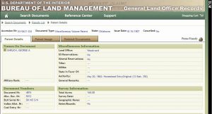
The Bureau of Land Management database for a George A Erhlich Land Patent provided the following:

From the above George A. Ehrlich – Patent Details, a copy of George A. Ehrlich’s Land Patent, Certificate Nr. 4874, Application 5012 was obtained.
Where
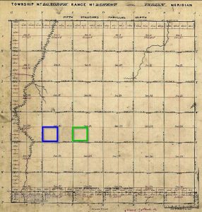
In the following 1876 Survey of Township 20 North Range 25 West of the Indian Meridian, Oklahoma, the George A Ehrlich Homestead is SW 1/4 of Section 21 (Shown with GREEN borders). And the George Ehrlich Homestead was subsequently found to be SW 1/4 of Section 20 (Shown with BLUE borders)

The following Bureau of Land Management map shows the location of the George A Ehrlich Homestead being about six miles southeast of Shattuck, Oklahoma (Note: The OHIO Township and George A Ehrlich Homestead are shown on the map 2 miles west of where they should be[2]). The distance is the same as is given by Timothy Egan in his book. However, the direction is southeast not west of Shattuck, Oklahoma.
![George A Ehrlich - Land Description Map - BLM GLO Records[2]](https://pressbooks.pub/app/uploads/sites/4089/2018/07/George-Alexander-Ehrlich-Land-Description-BLM-GLO-Records-300x149.jpg)
According to Timothy Egan’s book[1] as quoted in the beginning of this chapter, George Alexander Ehrlich staked his claim in the fall of 1900. This is consistent with the Land Patent being signed by President Theodore Roosevelt and the file claim being completed August 15, 1907.
Neighbors From Perry County Missouri
William and Martha Kirmse
Wilhelm “William” and Martha (Cordes) Kirmse homesteaded 2 miles west of the George Alexander Ehrlich homestead. William and Martha later purchase another quarter-section adjacent to the Kirmse homestead in Martha’s.
Henry and Marie Lohmann
Johann Heinrich “Henry” Lohmann homesteaded 2 miles southwest of the George Alexander Ehrlich homestead. Henry was in his early 20’s when he moved to Oklahoma to started farming and lived in a dugout for a number of years. In 1906, he returned to Farrar to marry Marie Cordes (sister of Martha Cordes) and they returned to live where Henry was homesteading.
Where
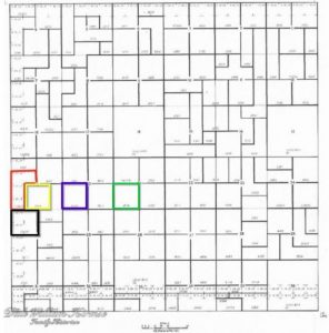
In the following OHIO Township map, the George A Erhlich Homestead is shown bordered in Green, the George Erhlich Homestead is bordered in Blue, the Wilhelm Kirmse Homestead is bordered in Red, the Martha Kirmse Property is bordered in Yellow, and the Lohmann Homestead is bordered in Black.

Notes
- Timothy Egan, ‘The WORST HARD TIME – The Untold Story of Those Who Survived the The Great American Dust Bowl’. Houghton Mifflin Harcourt Publishing Company, , New York, New York. 2006. Chapter 4 High Plains Deutsch, page 68.
- The Bureau of Land Management map as shown above has the OHIO township and the homesteads located 2 miles west of where they should be. Note that stream is about 1 1/2 miles WEST of George A Erhlich’s homestead in the 1876 Survey of Township 20 North Range 25 West of the Indian Meridian, Oklahoma. However in the Bureau of Land Management map, the stream about a mile EAST of George A Erhlich’s homestead.
