Homestead Applications and Land Patents
19
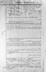
This Deed Record shows the transfer of land (The East one half of the South West one Fourth of Section Nineteen (19) Township Twenty (20) North of Range Twenty Five (25) West) to Martha Kirmse from a John E Williams on April 25 1906 for the sum of $1200.

This property was located in section 19 adjacent to the Wilhelm Kirmse homestead.
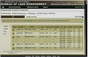
A search of the Bureau of Land Management database for Land Patents in section 19 of township 20 north of range 25 found the following:

According to this, John E Williams received his Land Patent for this property on August 10, 1906.
Where
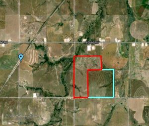
Goodwin, Ellis County, Oklahoma – The Wilhelm Kirmse homestead was about 1 mile east Goodwin, Oklahoma and about 7 miles southwest of Shattuck, Oklahoma.
![Ownership map of Ohio Township (Township 20 North Range 25 West of the Indian Meridian, Oklahoma). The Wilhelm Kirmse and Martha Kirmse[2] properties are noted in section 19[4].](https://pressbooks.pub/app/uploads/sites/4089/2018/07/20150314_LandMapKirmse_IMG_0243-5_1000.jpg)

Notes
- The property ownership was transferred to Martha Kirmse almost four months before John E Williams obtained his Land Patent to the property on August 10, 1906.
- As John Krueger pointed out in discussions about this property, that this deed transfers only half of Williams Land Patent. Yet, the Ownership Plat Map shows that Martha Kirmse owns the whole quarter(160 acres). There must have been a separate deed of property transfer[3].
- These various questions about the transfer timing and why the purchase was done in Martha’s name provide an opportunity for future research of the Ellis County property records.
- On the land ownership map, John E. Williams also owns a quarter of land in section 18 which is just north of the Kirmse properties.
