9 Sub-Saharan Africa
Introduction
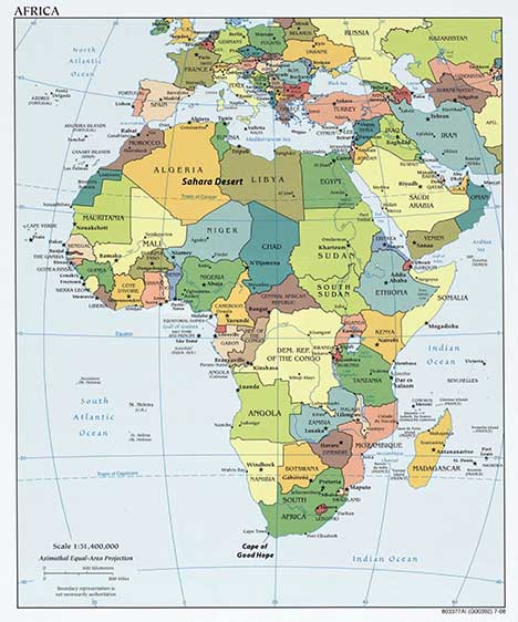
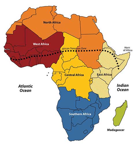
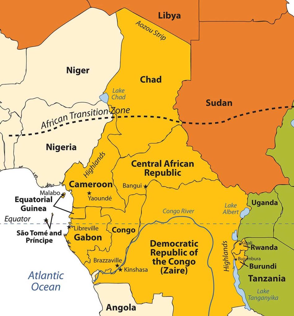
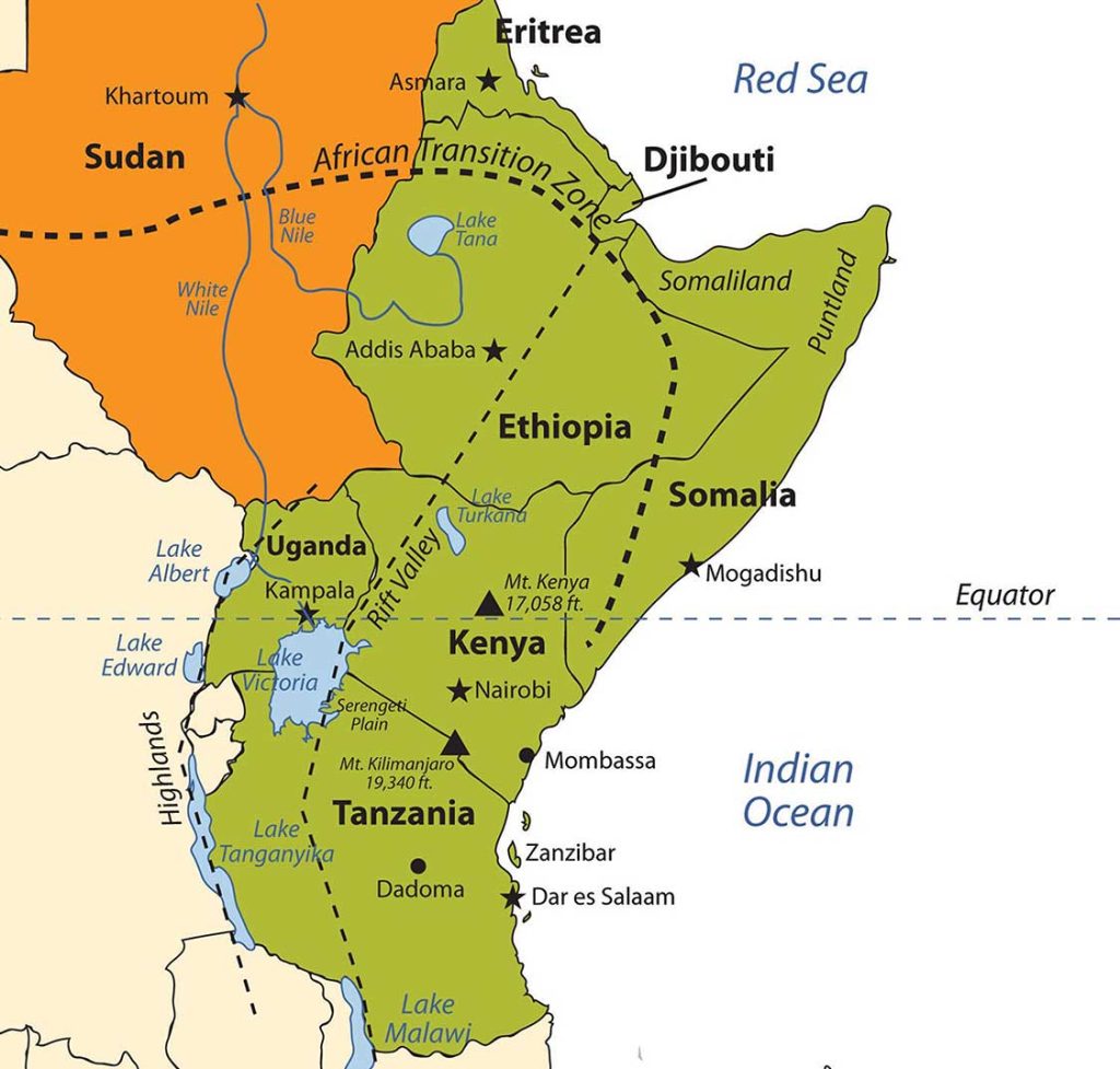
Sub-Saharan Africa includes the African countries south of the Sahara Desert. The African Transition Zone cuts across the southern edge of the Sahara Desert at the widest portion of the continent. Many of the countries in the African Transition Zone are included in the realm of Sub-Saharan Africa. The realm can be further broken down into regional components: Central Africa, East Africa, West Africa, and Southern Africa. At the eastern end of the African Transition Zone is the Horn of Africa, which is often included in the region of East Africa. Maps vary in terms of which countries are included in each region, but this general geographic breakdown is helpful in identifying country locations and characteristics. Madagascar is a large island off the southeastern coast of Africa and is usually not included with the other regions because its geographic qualities and biodiversity are quite different from the mainland.
The continent of Africa is surrounded by salt water. The Indian Ocean borders it on the east, and the Atlantic is on the west. The southern tip of the continent—off South Africa—is often referred to as the Cape of Good Hope, where the Atlantic Ocean meets the Indian Ocean. The continent of Africa has a number of small island groups that are associated with the realm and are independent countries. Approximately 350 miles off the coast of West Africa in the North Atlantic are ten islands that make up the independent country of Cape Verde. Just south of Nigeria on the eastern side of the Gulf of Guinea near the equator are the two islands that make up the independent country of São Tomé and Príncipe, a former Portuguese colony. The small country of Equatorial Guinea also includes an island off the coast of Cameroon where its capital is located. Three island groups in the Indian Ocean around Madagascar include the independent countries of the Seychelles, Comoros, and Mauritius.
9.1 Introducing the Realm
Learning Objectives
- Summarize the basic geography of Sub-Saharan Africa. Identify the African Transition Zone, including the transitions that are occurring in the zone. Locate the main features on a map.
- Understand how early kingdoms flourished in Sub-Saharan Africa before the colonial era. Identify how selective groups in these kingdoms partici-pated in the supply operations for the slave trade.
- Explain how European colonialism divided up Africa and the role the Berlin Conference played in the colonization process in Africa.
- Outline how countries have transitioned from colonies to independent nations, including the many issues involved in this transition.
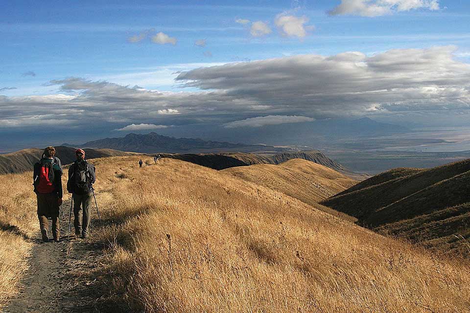
There is considerable variation with respect to how the regions of Sub-Saharan Africa are delineated or identified on maps. The debate is not about what regions are in Sub-Saharan Africa but rather about which countries are to be included within each region. The regions have both similarities and differences. The cultural geography varies widely from country to country and from one ethnic group to another, but at the same time, there are shared cultural patterns across all Sub-Saharan African regions. For example, colonialism has been a major historical factor in the shaping of the countries. Families are large, and rapid rural-to-urban shift is occurring in all regions. Every region has large urban centers—often port cities that act as central core locations supported by a large peripheral rural hinterland.
Globalization has entered into the dynamics connecting these once-remote regions with the rest of the world. Advancements in communication and transportation technology have created networks connecting Africa with global markets. Sub-Saharan Africa has a young population that is on the move, seeking to gain from any opportunities or advantages it can find. The political arena is dynamic: changes in political leadership through coups or military takeovers are common, as is authoritarian rule. Sub-Saharan Africa is home to some of the poorest countries in the world. Poverty is evident in the countryside and in the urban slums of the largest cities. Bitter civil wars are a part of every region’s history. Violence and conflicts continue in some areas, while other areas exhibit political stability and thriving economies. The diversity in human geography is the most noteworthy dynamic in Sub-Saharan Africa. The variety of ethnic groups along with the multiplicity of languages and religious affiliations create strong centripetal and centrifugal forces that interact in a thriving sea of cultural diversity.
Most of the population lives an agrarian lifestyle, but there are people who are developing the skills necessary to adapt to the rapid globalization wave that is importing new technology and new ideas to the continent. The urban core areas of the continent are the main focus of the global trends in technology and communication. These urban core areas exhibit the typical dynamics of the core-periphery spatial relationship. Sub-Saharan Africa has many core areas and many peripheral areas. The core urban centers have political power thanks to the social elites who have connections to the global economy and often dominate political activities.
These core urban areas are often magnets for people from large families in rural peripheral areas seeking employment. Millions of people in Africa who seek employment are willing to migrate to the cities or even other countries to find work. The rural immigrants are often not of the same ethnic group as those in power, which sets up the basis for discriminatory policies that disadvantage the many minority groups that are not affiliated with the government. These dynamics can fuel protest activities with a goal of overthrowing the powerful elite. Various ideas have been proposed to help level the socioeconomic playing field. One of the more prominent options is the implementation of a democratic government, where most of the people have a stake in electing those that hold positions of leadership and power.
Broad patterns and dynamics of people and places are replicated throughout the Sub-Saharan realm. The regions share common demographic trends of large family sizes, agrarian lifestyles, and low income levels. The patterns of an economy based on agricultural production and mineral extractive activities as well as disruptive changes in political leadership are common throughout the continent. Each region has diverse ethnic groups and an array of different languages. South of the African Transition Zone, the most prevalent belief systems are Christian based and animist, while north of the zone, Islam is widespread. Division and civil unrest can occur where the different religions meet and compete for political control. These concepts will bear repeating throughout the chapter. The cultural mosaic of Sub-Saharan Africa is vast and complex, and this chapter will outline the basic trends and patterns with specific examples that will help place it all in perspective.
A. Physical Geography of Sub-Saharan Africa
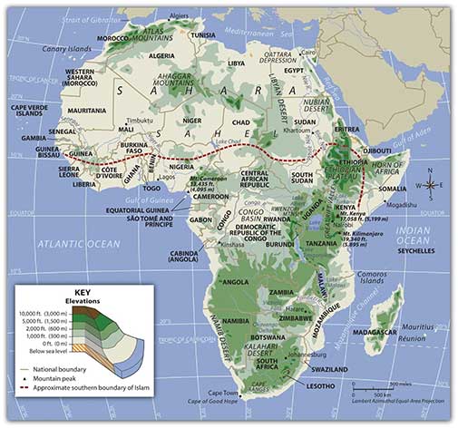
The African Transition Zone divides North Africa from the rest of Africa because of climatic and cultural dynamics. Cultural conflicts and desertification are common in the zone. Dry, arid type B climates, common in the Sahara Desert, are dominant north of the zone. Tropical type A climates prevail south of the zone. Global climate changes continue to shape the continent. The shifting sands of the Sahara are slowly moving southward toward the tropics. Desertification in the zone continues as natural conditions and human activity place pressure on the region through overgrazing and the lack of precipitation. Type B climates resurface again south of the tropics in the southern latitudes. The Kalahari and Namib Deserts are located in Southern Africa, mainly in the countries of Botswana and Namibia.
Africa does not have extended mountain ranges comparable to the ranges in North or South America, Europe, Asia, or Antarctica. There are, however, smaller mountain ranges and individual mountains of great height. The Ethiopian Highlands reach as high as 15,000 feet in elevation, and the region is sometimes referred to as the “Roof of Africa” due to its height and relatively large area. East Africa also has a number of well-known volcanic peaks that are high in elevation. The tallest point in Africa—Mt. Kilimanjaro in Tanzania near the border with Kenya—is 19,340 feet high. Nearby in Kenya, Mt. Kenya is 17,058 feet high. The Rwenzori Mountains on The Congo/Uganda border reach more than 16,000 feet in elevation and create a rain shadow effect for the region. Permanent glaciers exist on these ranges even though they are near the equator. On the western side of the continent, Mt. Cameroon in Central Africa is more than 13,000 feet in elevation. South Africa’s Cape Ranges are low-lying mountains no higher than about 6,000 feet. The continent of Africa generally consists of basins and plateaus without long mountain chains. The plateaus can range more than 1,000–2,500 feet in elevation. The only extensive continuous feature is the Great Rift Valley that runs along the tectonic plate boundaries from the Red Sea southward to South Africa.
The main rivers of Africa include the Nile, Niger, Congo, and Zambezi. The Nile River competes with the Amazon for the status as the longest river in the world; the White Nile branch begins in Lake Victoria in East Africa, and the Blue Nile branch starts in Lake Tana in Ethiopia. The Niger flows through West Africa; its mouth is in Nigeria. The Congo River crosses the equator with a large tropical drainage basin that creates a flow of water second only to the Amazon in volume. The Zambezi River in the south is famous for the extensive Victoria Falls on the Zambia and Zimbabwe border. Victoria Falls is considered the largest waterfall in the world. Other significant rivers exist such as the Orange River, which makes up part of the border between South Africa
and Namibia.
There are a number of large lakes in Sub-Saharan Africa. The largest is Lake Victoria, which borders several East African countries and is considered to be the second-largest lake in the world in surface area. Only Lake Superior in North America has a greater surface area. A number of large lakes are located in the rift valleys of the east. Three of the largest lakes along the western rift are Lake Malawi, Lake Tanganyika, and Lake Albert. To the northeast of these in Kenya is Lake Turkana, which reaches to the Ethiopian border. Lake Chad is located in the African Transition Zone on the border between Chad, Mali, and Nigeria. Lake Chad has been severely reduced in size in recent years.
The equator runs through the center of Sub-Saharan Africa, providing tropical type A climates. These regions usually have more rainfall, resulting in lighter, leached-out soils that may not be as productive as regions with richer volcanic soils, such as those found in the rift valleys. Root crops are common in Africa, as are millet and corn (maize). The savanna regions of the east and south have seasonal rains that affect the growing season. Soils in savanna areas are usually not as productive and cannot be depended on to fulfill the agricultural needs of growing populations. Savannas are usually grasslands or scrub forests with a seasonal precipitation pattern. Cattle and livestock grazing are common in savannas, and migrations are frequent to follow seasonal grazing conditions. In specific areas of Southern Africa, larger farming operations exist in type C climates. However, Sub-Saharan Africa is not blessed with the large regions of rich alluvial soils found in the Northern Hemisphere. The ever-growing agrarian population has always depended on the land for food and sustenance, but these conditions are not favorable for Africa’s future. Populations are growing faster than any increase in agricultural production.
Increasing populations in Sub-Saharan Africa are taxing the natural environment. Where the carrying capacity has been exceeded, the natural capital is being depleted at an unsustainable rate. Deforestation is occurring in areas where firewood is in high demand, and trees are cut down faster than they can grow back. Expanding human populations are also encroaching on the natural biodiversity for which the African continent is renowned. Large game animals such as rhinoceroses, elephants, and lions have been hunted or poached with devastating consequences. The creation of game preserves and national parks has stemmed this tide, but poaching remains a serious problem even in these protected areas. Gorilla and chimpanzee populations have also been stressed by human population growth. These animals are being killed by humans for bush meat, and their habitats are being reduced by human activities.
B. Colonialism in Sub-Saharan Africa
Wherever you go in the world, you cannot escape the impact of European colonialism. Sub-Saharan Africa was broadly affected by colonial activities, the legacy of which can be recognized to this day. Colonial powers of Europe ventured into Africa to claim colonies and obtain slaves. Slavery impacted Africa in many ways. Many African groups were instrumental in capturing and holding slaves to trade with the European merchants. These groups still exist and have had to live with the fallout of their role in the supply side of the slave trade.
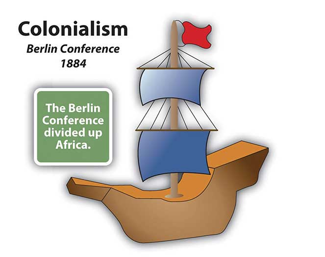
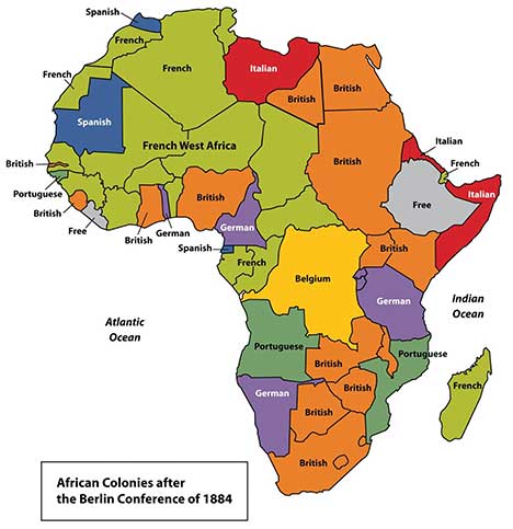
By 1900, European colonial powers claimed most of Africa. Only the Kingdom of Ethiopia and the area of Liberia, which was established as a home for freed slaves, remained independent. In 1884, Otto von Bismarck of Germany hosted the Berlin Conference, which to a great degree determined how Africa was colonized. This conference included fourteen colonial European countries and the United States, and its purpose was to divide Africa and agree on colonial boundary lines. Germany had few claims in Africa; Bismarck was hoping to benefit by playing the other countries against each other. At the time, more than 80 percent of Africa remained free of colonial control. On a large map of Africa, claims were argued over and boundary lines were drawn according to European agreements.
There was little regard for the concerns of local ethnic groups. Colonial boundaries divided close-knit communities into separate colonies. Ethnic boundaries were disregarded. Often-warring groups were placed together in the same colony. The Europeans, seeking profits from cheap labor and resources, did not consider the local people or culture and often employed brutal measures to subdue the local people. Most of the current borders in Africa are a result of the Berlin Conference, and many of the geopolitical issues that confront Africa today can be traced back to this event specifically and to colonialism in general.
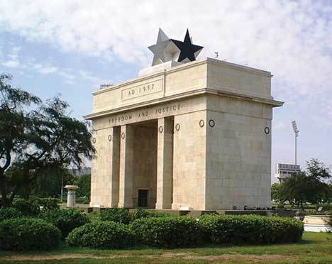
European colonialism remained strong in Africa until the end of World War II, which left many European countries economically exhausted. In 1945, the United Nations (UN) was established. One of the primary UN objectives was to oversee the decolonization of European colonies. Still, colonialism in Sub-Saharan Africa lingered on. Most African countries did not gain their independence until the 1960s, and it was not until the 1990s that the last colony was finally freed. The transition from colony to independent nation itself caused conflict. Civil wars were fought over who would control the country after the Europeans were pushed out. The transition to full independence has exacted a heavy toll from African countries but has resulted in stronger political structures and greater democratic liberties in many cases. The first country to gain independence in Sub-Saharan Africa was Ghana in 1957.
During the era of independence after World War II, the Cold War between the United States and the Soviet Union enticed many of the African countries to support one or the other of the superpowers. The political pressure that divided African countries during the Cold War has persisted and is the basis of some of the current political problems. The European countries extracted raw materials and minerals from their African colonies, as well as slave labor. Varying degrees of attention were given to education, medical care, or infrastructure development. The dependency that a colony had on a European country for economic income in some cases continued long after independence and may still continue today. On the other hand, major technology transfers from Europe to Africa infused greater efficiencies into Africa’s economic activities.
C. From Colonialism to Independence
The transition from European colony to independent state has not necessarily been a civil transition for African countries; likewise, independent African countries have struggled to create stable governments or peaceful conditions—though stable governments and peaceful conditions have been established in some cases. In nearly all cases, removing the colonial powers from Africa was only half the battle toward independence. The other half was establishing a functional, effective government. Though each country has taken a slightly different path, most former colonies have endured civil unrest, conflict, or warfare in their push for stable governments. Coups, fraudulent elections, military regimes, and corruption have plagued the leadership in a number of African countries. Civil unrest usually precedes a change in leadership: political power regularly changes hands by a military coup or an overthrow of the current leader.
The realm has had difficulty developing and maintaining effective political systems with democratic leadership. Political leaders have come and gone, many have been replaced before their terms were over, and a few have stayed long after their terms ended. When a leader is elected democratically, it is common to have widespread accusations of corruption, voter fraud, or ballot box scandals. Such government mismanagement and corruption have been common problems.
The vacuum left by retreating colonial powers at times has been filled by authoritarian dictators or by leaders who assumed control of the government and then proceeded to pillage and plunder the state for personal gain or for the enrichment of their clan or political cronies. After the colonial era, it was not uncommon for new leaders to be connected to the old colonial power and to adopt the language and business arrangements of the European colonizer. This gave them an advantage over their competitors and provided a means of income gained by the support of their former European colonial business partners, which often wanted to keep ties with their colonies to continue to exploit their resources for economic profits. Many of these leaders stayed in power because of military backing or authoritarian rule funded by the profits from selling minerals or resources to their former colonial masters.
A few countries are still struggling to bring about some type of order and unity, and in spite of all the negative issues, there have been democratic and relatively stable progressive governments in Africa that have emerged from the transition in recent years, which is a hopeful trend for the long term.
The objective of colonialism was to connect a colony with the mother country, not to connect African countries to each other. As a result, little cooperation occurs between African countries. Each individual country interacts more with its European colonial counterpart with regard to trade, economics, and cultural dynamics. European colonialism has isolated African countries from their neighboring countries and does not contribute to unity within or among African regions. Colonial powers often built new port cities to extract goods and resources from their colonies and transportation systems from the new ports to the interior to collect the resources and bring them to the port. However, the colonial powers did not build a network of transportation systems that connected the region as a whole. Colonial powers were intent on continuing dependence on the mother country so their colonies could be controlled and dominated. The current wave of globalization based on corporate colonialism continues to encourage the same pattern of discouraging interaction between counties and instead encouraging trade with more economically powerful non-African countries. Most of the interaction between countries is a result of crisis or warfare, in which case large numbers of refugees cross the border into neighboring countries for personal survival or security. To begin to work together and promote trade, common transportation, security, and industry, fifteen West African states came together in 1975 to create the Economic Community of West African States (ECOWAS). Since then, additional political and economic agreements have been signed by various African countries. In 2001, the more expansive African Union was created to help African states compete in the international marketplace.
Key Takeaways
- Sub-Saharan Africa includes the African Transition Zone and the regions south of the Sahara. The African Transition Zone is a transitional zone between type A and type B climates and between the religions of Islam and Christianity.
- Sub-Saharan Africa is a realm of plateaus and basins with four main river systems. Mountain ranges, volcanic peaks, and large lakes are found in or along the rift valleys of eastern Africa. The rift valleys were created by tectonic activity.
- Before the colonial era, many African kingdoms dominated regions of Sub-Saharan Africa. West Africa had a number of great kingdoms. Kingdoms along the coast contributed to the slave trade.
- European countries colonized almost the entire realm of Sub-Saharan Africa. European powers made agreements during the 1884 Berlin Conference to divide the realm and create boundary lines between their African colonies. Many of the lines remain as the current borders today.
- Colonies were designed to provide labor and resources to the mother country. Port cities, transportation systems, and other infrastructure were implemented to benefit the imperial power without regard for development of the colony.
- African colonies received independence after World War II, with most becoming independent in the 1960s. The transition from colonies to independent countries has been plagued by civil war, political chaos, or economic devastation.
9.2 Human Geography of Sub-Saharan Africa
Learning Objectives
- Summarize how the core-periphery spatial relationship applies to Sub-Saharan Africa. Analyze how the concept of rural-to-urban shift applies to the development pattern.
- Distinguish between the formal and informal sectors of the economy and understand how each would apply to the various core and peripheral regions of the realm.
- Explain how countries fit into the index of economic development model and the relationship between family size, urbanization rates and income levels.
- Understand the diversity of languages and religions in the realm. Develop a theory about why, with the increasing population, the number of languages spoken decreases. Explain why many former European colonies still retain the language of their colonizer as their lingua franca, or official language.
- Identify the various areas in Sub-Saharan Africa that have experienced devastating civil wars or political conflict in recent years.
- Outline the general pattern of HIV infections in the realm. Understand why it is difficult to contain and prevent the spread of AIDS.
- Explain why Sub-Saharan Africa has such great potential for economic development through tourism. Articulate the difficulties in creating a tourism market.
A. Economic Geography
The demographic data for each country in each region of Sub-Saharan Africa indicate the region’s human geography. Urban percentages, family size, income levels, and the other data that can indicate the lifestyle or development level are acutely helpful in understanding the trends in Sub-Saharan Africa. The index of economic development illustrates the dynamics and conditions that exist in the realm. The data indicate the consistency of economic and development trends across Africa. The data does not, however, indicate differences in cultural dynamics and uniqueness in the ways that local people live. The interesting part of studying Sub-Saharan Africa is the many ethnic and cultural groups in each country that bring to the surface a wide array of global diversity in our human community. Within each and every country are microcosms of human societies that hold particular customs that may be thousands of years old. Globalization and technological advancements challenge every cultural group to adapt and innovate to make a living yet provide continuity in their heritage. The remote cultural groups of Sub-Saharan Africa are most susceptible to the volatile nature of globalization, which threatens their current way of life.
Sub-Saharan Africa is a peripheral world region with neocolonial economic patterns. Peripheral regions usually supply raw materials, food, and cheap labor to the core industrial countries. Most of the population in Sub-Saharan Africa works in subsistence agriculture to make a living and feed their families. Families are large. In recent decades, there has been enormous rural-to-urban migration to the major cities, which are extremely overcrowded. Sub-Saharan Africa has more than 750 million people, and most earn the US equivalent of only $1–3 per day.
There is no single major core economic area in Sub-Saharan Africa. This realm has many core cities and the rest is periphery. Many of the core cities are improving their technology and infrastructure and entering into the globalized economy. Even so, as much as 70 percent of the people still work in agriculture, leaving little time to develop a large educated group of professionals to assist with social services and administrative responsibilities. The realm depends heavily on outside support for technical and financial assistance. Computers, medical equipment, and other high-tech goods are all imported. African states have formed trade agreements and have joined the African Union to assist each other in economic development and trade.
Sub-Saharan Africa has nearly forty urban areas of more than one million people. At the center of the central business districts (CBDs) are modern high-rise business offices well connected to the global economy. Outside the CBD are slums with no services and miserable, unsanitary conditions. The informal sector of the economy—that which is not regulated, controlled, or taxed—has become the primary system of doing business in most of the cities. The informal sector comprises trading, street markets, and any other business without financial records for cash transactions.
The lack of government regulation and control prevents taxes from being assessed or collected, which in turn diminishes support for public services or infrastructure. The formal sector of the economy—that which the government can regulate, control, and tax—is forced to foot the bill to operate the government and support public services such as education, security, and transportation. In spite of the misery and unhealthy conditions of the slums where millions of people already live, more migrants from the countryside continue to shift to the city in search of jobs and opportunities. African cities are growing rapidly, many without organized planning.
If the index of economic development were applied to Sub-Saharan Africa, a clear pattern would emerge. Rural areas would be in the lower stages of development, and only a few developing areas would be higher than stage 3. A large percentage of this realm would be in stage 1 or 2 of this model. Countries with higher standards of living, such as South Africa or Botswana, would be working through stage 3 or 4. This region has one of the fastest-growing populations of the world and economically lags behind countries in the Northern Hemisphere, which have transitioned into the higher stages of the index of economic development.
B. Incomes, Urbanization, and Family Size
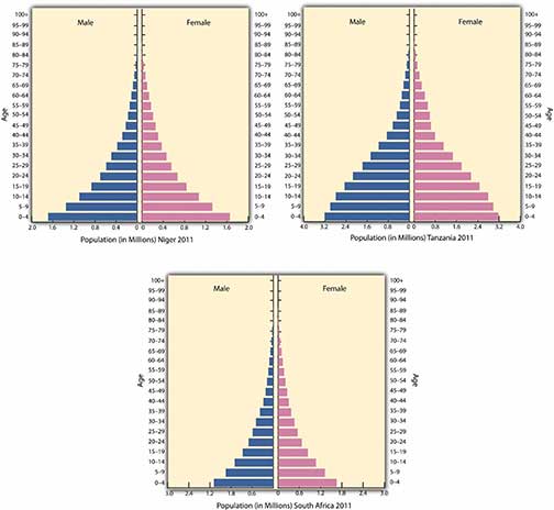
The socioeconomic data illustrate well the conditions for people in Africa in comparison to the rest of the world. African countries are at the lowest end of the statistics for development prospects. The larger cities are showing promise for advancement into the higher stages of development. Family sizes in the rural countries are some of the largest in the world. The average fertility rate for much of Africa is about 5; in Mali and Niger, the rate is higher than 7. One-third to half of the populations of these countries are under the age of fifteen. Children make up most of the population in many areas—an indication that heavier burdens are placed on women, meaning that women are not easily able to get an education or work outside the home.
The populations of West African countries are increasing rapidly and will double in about thirty years at the current rate. This trend places an extra burden on the economy and on the environment. It is fueling one of the fastest rural-to-urban shifts in the world. West Africa is now only about 32 percent urban, and Burkina Faso and Niger are less than 20 percent urban—clear indications that agriculture is the largest sector of their economies and that most of the people live in rural areas or small villages.
Personal income levels in West African countries are among the lowest in the world; as far as standard of living is concerned, these are poor countries. Few economic opportunities exist for the millions of young people entering the employment market.
The United Nations (UN) Human Development Index (HDI) lists all but two of the West African countries in the lowest category of development. Sierra Leone is the lowest in the world. As a peripheral world region, the economic base is structured around agriculture with supportive extractive activities. These countries are in a subsistence mode with a rapidly expanding population and few industrial or postindustrial activities to gain income.
No Sub-Saharan African country is in stage 5 of the index of economic development. Nevertheless, the fact that they are not consumer societies does not negate the rich cultural values and heritage of the realm. The energy of the people does not revolve around consumerism but is instead focused on the people themselves. High levels of social interaction and community involvement bring about different cultural standards than those of a consumer society, which focuses more on the individual and less on community. Unless there is social unrest or open warfare, which does exist in various places, the people work hard to bring about a civil society based on family and tradition.
C. Languages in Sub-Saharan Africa
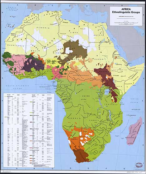
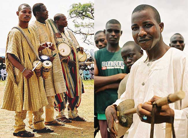
Sub-Saharan Africa covers a large land area more than 2.3 times the size of the United States. Thousands of ethnic groups are scattered throughout the realm. There is immense diversity within the 750 million people in Sub-Saharan Africa, and within each country are cultural and ethnic groups with their own history, language, and religion. More than two thousand distinct languages are spoken in all of Africa. Forty are spoken by more than a million people. Many local languages are not written down and have no historical record or dictionary. Local languages without a written history are usually the first to be lost as globalization affects the realm. Nigeria, with more than 130 million people, is the most populous country in Africa. The African Transition Zone cuts through the country’s northern portion. More than five hundred separate languages are spoken in Nigeria alone. Three of the six dominant languages in Sub-Saharan Africa—spoken by at least ten million people or more—are spoken in Nigeria: Hausa, Yoruba, and Ibo. The three remaining major languages of Sub-Saharan Africa are Swahili, Lingala, and Zulu.
Colonial activity changed much of how the African countries operated economically, socially, and politically. Language is one aspect of culture that indicates a colonial relationship. Many African countries today speak a European language as the official language. Mauritania is the only country that has Arabic as its official language. Nigeria has English plus other local languages. The official languages of most of West Africa are either French or English, and Guinea-Bissau’s official language is Portuguese.
This vestige of colonial power would seem inconsistent with the desire to be free of foreign domination. However, because often dozens to hundreds of local languages are spoken within the country, choosing the colonial language as the official language produces less of an advantage for one group wishing to dominate the political arena with its own local language and heritage. For example, a language problem arises when a government needs to print material for the country. What language do they use? In Nigeria, there would be more than five hundred possible languages. What if the leadership used a language only spoken by a few people? The language of those in power would provide an advantage over those that could not understand it. This is why many African countries have chosen a colonial language as their country’s official language.
D. Religion in Sub-Saharan Africa
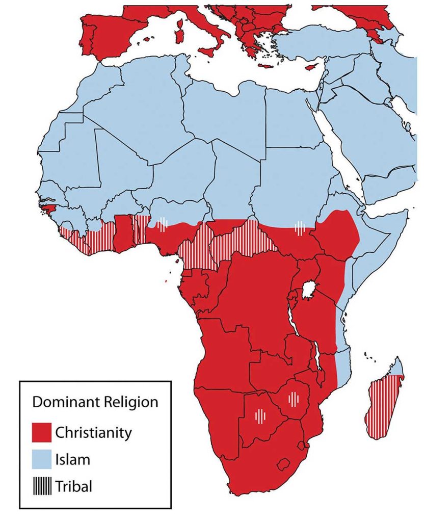
The current religions in Africa follow the pattern of the African Transition Zone. Most of the population north of the zone follows Islam, and most of the population living south of the zone follows Christianity. Large percentages of people in some parts of the region still follow a wide array of traditional or animist beliefs.
Along the African Transition Zone, followers of one religion will clash with followers of the other. Countries such as Nigeria have a history of this type of social division, and Nigeria’s government allows Islamic Sharia law to take precedence over civil law in the country’s northern regions.
Both Islam and Christianity have been on the rise in Africa. As the local beliefs are replaced with monotheistic religions, there is more integration with either the West (Europe and America) or the Middle East. Religious activity through Christian missionaries or the advancement of Islam sometimes coincides with economic support being brought in through the same channels, which is often welcome and enhances the global relationships that occur.
However, Africa is still full of traditional religions with rich spiritual histories. Spiritual forces are found in the environment. Deities of all kinds are worshipped throughout Africa. Christianity and Islam are latecomers to the region but have made deep inroads into the African culture. Both compete for the souls of the African people.
E. Ethnic Divisions and Civil Wars
Sub-Saharan Africa is home to thousands of ethnic or traditional groups. Each has a separate identity and history, and often one group is in conflict with another. The slave trade and the establishment of colonial political boundaries or policies exacerbated historical ethnic hostilities. Major civil wars have been fought throughout Sub-Saharan Africa and continue at the present time. Central Africa has recently endured brutal conflicts. More than five million people died as a result of the civil war in The Democratic Republic of Congo (formerly Zaire). Fighting continues between various factions over political control or control over natural resources, such as diamonds or gold. Civil wars have devastated some African countries. Many other countries, such as Zimbabwe, Chad, and the Central African Republic, have also suffered economic disintegration as a result of severe political unrest.
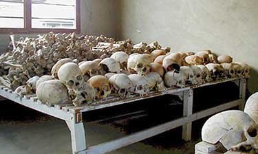
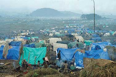
Rwanda’s Tutsi-Hutu conflict was historic in its violence and in the senseless killing of innocent people. In 1994, the centuries-old conflict erupted into violence of unprecedented proportions. Hutu militias took revenge on the Tutsis for years of suppression and massacred anyone who did not support the Hutu cause. Tutsi rebels finally gained strength, fought back, and defeated the Hutu militias. More than a million people were killed, and more than a million defeated Hutus fled as refugees to neighboring countries, where many died of cholera and dysentery in refugee camps.
The civil war in Rwanda and the many refugees it created destabilized the entire Central African region. The shift in population and the increase in military arms along the Zairian border resulted in an extensive civil war in The Congo (Zaire) that has resulted in the deaths of more than five million people, many by disease or starvation. Over three million deaths are estimated to have been related directly to the war and another two million by the harsh conditions in the region. The civil wars in The Congo from 1996 to 2003 changed the cultural and political landscapes and destroyed valuable infrastructure. One of the driving forces in these wars was the control of valuable mineral resources found in the Great Rift Valley along the eastern boundary of The Congo. Diamonds, gold, copper, zinc, and other minerals are abundant in this region, and wealth that can be gained from the mining of these products attracts political forces to compete for their control.
Civil wars have also wreaked havoc on the countries of Angola, Sierra Leone, Liberia, and Somalia. Many of the civil wars were not reported by the news media worldwide, even though the number of people affected, injured, and killed was deplorable.
Creating stability in parts of Africa has been challenging, as civil unrest and political corruption continue in many African countries. The core industrialized countries have been hesitant to step in or invest in the peace and stability of Africa. Governments of more than a few African countries have been unable to bring stability or to provide for their people. For example, Somalia has no central government; rather, it is ruled by warlords and village chiefs. Corruption, dictatorial rule, and military force have been major components of government rule in these cases.
F. HIV and AIDS in Sub-Saharan Africa
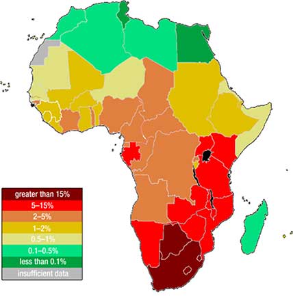
As if Sub-Saharan Africa did not have enough to work through to achieve stability, it must also cope with high numbers of people infected with HIV and AIDS. From South Africa to Kenya, there is a line of countries with some of the highest percentages of HIV-infected people in the world. The HIV virus has infected more than 24 percent of adults in Botswana, and some villages have lost an entire generation of adults to AIDS. The AIDS pandemic has become a major health crisis for Sub-Saharan Africa. According to the World Health Organization, as many as thirty million people in this realm are HIV-infected.
It’s possible to live with HIV for years before dying of AIDS. HIV-infected individuals can pass the virus to others without knowing they have it, and millions of people die of AIDS in Sub-Saharan Africa without ever knowing they were infected. The lack of education, HIV testing, and medical services hinder progress toward stopping this deadly disease. Prevention is an ideal that has not materialized yet. Many people do not want to be tested out of fear of rejection by their families and friends if they are infected. AIDS will surely kill millions more in Africa before a solution is found.
Many other diseases are common in Sub-Saharan Africa. Some are spread by vectors in the environment. Mosquitoes spread illnesses such as malaria and yellow fever, which are common throughout the realm. Sleeping sickness is spread by the tsetse fly, which can also infect cattle and livestock. Hepatitis is widespread. Schistosomiasis, tuberculosis, and typhoid are also common. Unsanitary conditions and polluted water are breeding grounds for microbes that cause diseases. People living in less-than-sanitary conditions are more likely to come in contact with and become infected with these diseases and are also less likely to obtain medical attention at an early stage of the disease.
Key Takeaways
- Sub-Saharan Africa’s many core cities and peripheral regions create a high rural-to-urban shift.
Much of the realm’s economic activity is conducted in the informal sector. - Most countries in this realm are in the earlier stages of the index of economic development.
The integration into global markets has brought urbanization and development to many of the
major core cities. - The informal sector dominates many of the economic activities in Sub-Saharan Africa. The emergence of stable governments and economic structures usually results in a stronger formal sector of the economy, which in turn provides improved national infrastructure.
- Sub-Saharan Africa is realm with a high diversity of languages and religions. In an attempt to provide an equal footing for all languages, many countries have chosen their colonial language as their official language to avoid giving speakers of one language any political advantage over another.
- Parts of Sub-Saharan Africa continue to experience social unrest and civil war. Armed conflicts in Rwanda and The Congo (Zaire) have either killed or affected millions of people.
- A high percentage of people in Sub-Saharan Africa are infected with HIV—up to one-fourth of the population of some countries. Health care, education, and cultural forces are important factors in combating AIDS and the tropical diseases common in the realm.
- Sub-Saharan Africa has enormous potential to exploit their physical features and cultural heritage to expand their tourism market. It is often difficult to balance the investments for adequate infrastructure and services required for tourism with other needs, such as education and health care.
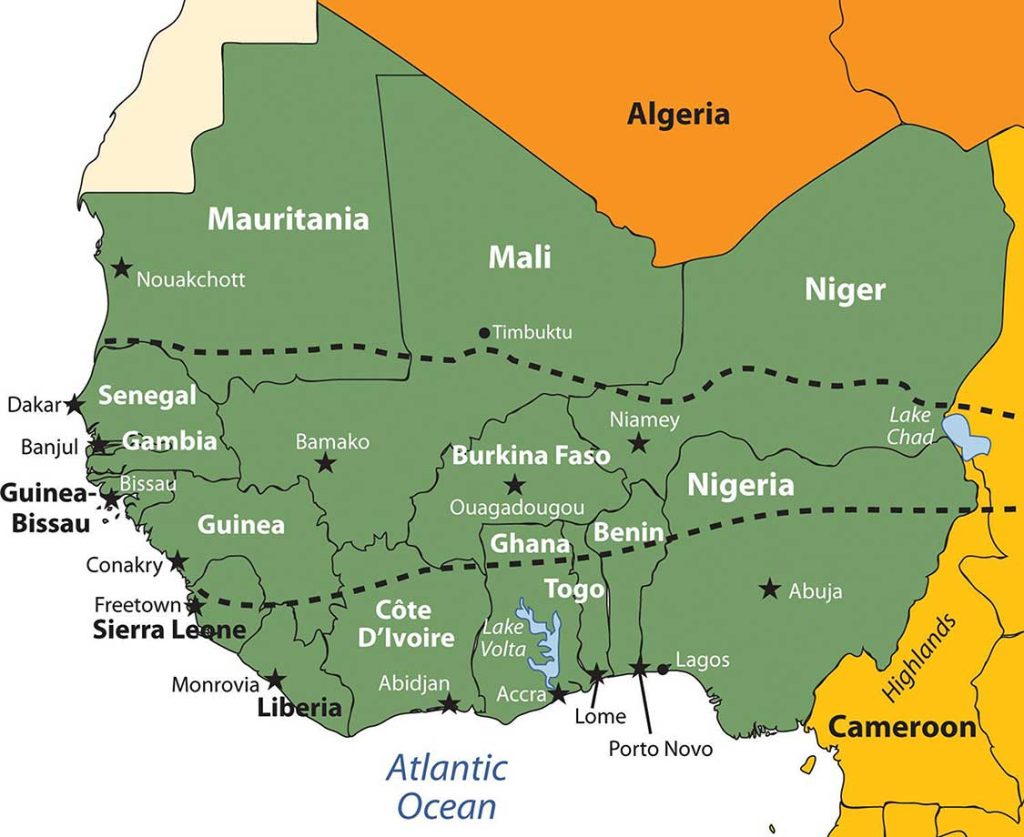
9.3 West Africa
Learning Objectives
- Summarize the main geographic aspects of each country in West Africa.
- Understand each country’s development pattern and their current political situation.
- Explain how family size and economic activities are related to population growth.
- Outline the main economic activities of each country and how they are related to natural resources.
The region of West Africa includes the southern portion of the bulge of the continent, which extends westward to the Atlantic Ocean. This region is bisected by the African Transition Zone, which borders the southern edge of the Sahara Desert. The main physical features include the Sahara Desert and the Niger River. The Cameroon Highlands are located on the eastern border between Nigeria and Cameroon. At 4,100 miles long, the Nile River is the longest, while the Congo River is Africa’s second longest at 2,922 miles in length. The Niger River is Africa’s third-longest river and extends more than 2,600 miles from the Guinea Highlands through Mali, Niger, and Nigeria before reaching the Atlantic Ocean in the Gulf of Guinea.
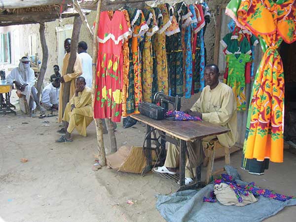
Some geographers include the country of Chad or portions of it within the region of West Africa. In this textbook, Chad is listed with Central Africa. The portions of Chad located north of the African Transition Zone share similar characteristics with North Africa. Off the coast of Mauritania are the Cape Verde Islands, which are united as an independent country associated with Africa. Cape Verde was once a Portuguese colony but received its independence in 1975. Western Sahara has been in conflict with Morocco over independence and is most often associated with the region of North Africa because of the influence of Islam and because of its connection to Morocco.
The African Transition Zone cuts across the region of West Africa, indicating a division between Islam and Christianity and between the Sahara Desert and the tropics. This diversity in religion and climate is usually exhibited with a north/south division. Islam is the dominant religion on the north side of the African Transition Zone; Christianity is more dominant to the south. The two religions often clash in the areas where they meet. Traditional beliefs and animist religions are also practiced in the African Transition Zone.
The terms “state” and “country” are often used interchangeably by the world community outside of the United States. Both are meant to refer to a physical unit with a sovereign and independent government. In Sub-Saharan Africa the term “state” is commonly used to refer to a country in any one of the various regions.
A. Niger
The former French colony of Niger is landlocked, with the Sahara Desert making up its largest portion. Niger is a land of subsistence farmers, and most of the population lives in the southern regions. The country is less than 20 percent urban. Other economic activities include uranium mining, which is the country’s main export. The world demand for uranium has not been strong in recent years. Oil exploration has begun and international oil corporations have garnered contracts for drilling.
The Sahara Desert is moving southward, and the agrarian culture at the base of Niger’s society is often plagued by drought and famine. The Niger River flows through the southwestern region and provides fresh water, but the northern region is mainly the Sahara Desert, and large portions are covered with sand dunes.
The country has extreme demographics. Niger has the highest fertility rate (7.6) in the world, and half the population is under the age of fifteen, causing a population explosion that taxes the sparse natural resources and brings even more poverty to a country at the bottom end of the index of economic development. Infant mortality rates in Niger have been the highest in the world.
The mainly Sunni Muslim country has a rich cultural base but suffers from economic problems that appear to increase with the increase in population and desertification. Heavy national debt has hindered social services and has required a considerable amount of foreign aid from a number of sources.
The political conditions in Niger are typical of the region. For the first thirty years after independence from France, the country was ruled by a single political party and military rule. There have been several coups and various political leaders have been in power. A dispute remains with Libya over its northern border. Ethnic infighting with a minority Taureg group has emerged in recent years, bringing conflict and discord.
B. Sierra Leone
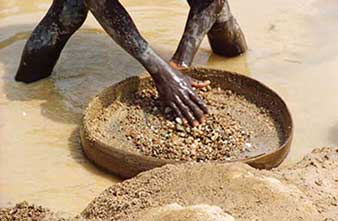
Sierra Leone has been devastated in the past decades due to brutal civil war and political turmoil; as a result, the country was the lowest in the world on the human development index in 2010. There has been little political stability. Military factions have wreaked havoc on the country since it gained independence from Britain in the early 1960s. After independence, the country’s contested elections and multiple coups resulted in a ban on all but one political party and established military rule. At the core of the conflicts was competition for the control of the diamond industry, which was also a primary factor in the civil war.
The abuses of power escalated to a breaking point in the late 1980s, which set the stage for a decade-long civil war in the 1990s. A group calling themselves the Revolutionary United Front (RUF) pushed to take control of the eastern diamond mining sector through terrorist tactics and brute force. Thousands of people died and thousands more were mutilated by having their arms, legs, or other body parts cut off by machetes. Whole villages were destroyed and the residents killed, tortured, or maimed.
The government fell under various military coups and eventually resorted to hiring mercenaries to help push back the RUF forces. By 1998 the whole country resembled a military camp with arms and ammunition being trafficked to all sides. There was a total breakdown in state structures and institutions. In 2000, British troops were employed to help evacuate foreign nationals and establish order.
UN forces with US support eventually established a sense of control of the country. By 2003, major fighting was over and attempts were made to establish a civilian government. Approximately fifty thousand people were killed in this civil war and as many as two million people were displaced, many of them refugees. Sierra Leone set up a special court to address crimes against humanity, and the country has been working to establish a stable government and maintain a sense of order.
The diamond trade still dominates and political factions still vie for control. Much of the diamond mining is uncontrolled, allowing considerable smuggling operations to operate. After the civil war, revenues from diamond mining increased from less than $10 million in 2000 to an estimated $130 million in 2004. The civil war destroyed the infrastructure of the country, and most of the resources were looted by forces on one side or another. The economy has had a difficult time recovering. Most of the people make their living in subsistence agriculture. Medicine, food, and goods have been in a short supply. Many people have died due to the lack of these items during and after the civil war. Today the country struggles to recover and work toward stabilization.
C. Nigeria
Africa’s most populous country is Nigeria. The exact population has been difficult to determine, but 2010 estimates reported the population to be just short of 150 million. This is a country of more than 250 different ethnic groups with twice that many separate languages or dialects. English is the official language, along with Hausa, Yoruba, and Igbo (Ibo), all of which are spoken by ten million people or more. The distribution of the major ethnic groups is illustrated by the different regions of the country. Hausa groups are found mainly in the northern region, Kanuri groups in the northeast, Yoruba in the southwest, and Igbo (Ibo) in the southeast. Ethnic division has also caused serious confrontations and violence. Political instability in Nigeria has resulted in an almost endless number of military coups and government leaders being removed from office.
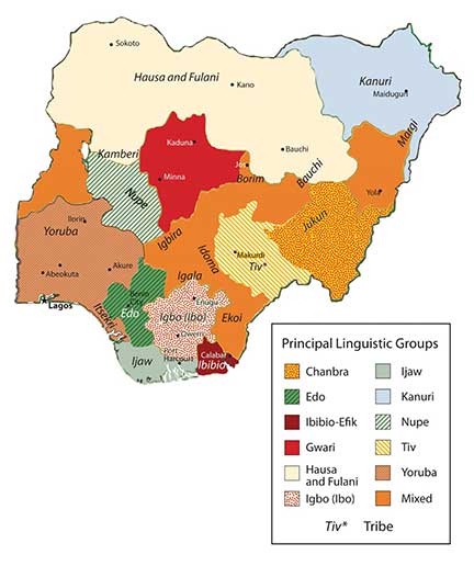
The size and diversity of this country create a host of centrifugal forces that can bring about divisions along any number of cultural lines. Religious issues add to the political instability. The north is mainly Muslim, as it is in the African Transition Zone. The south is mainly Christian. A large percentage of the population follows animist religions with many different traditional beliefs. Clashes have erupted in the streets that pit Muslims and Christians against each other. Several northern provinces have pushed to have the Sharia criminal code made into the area’s civil law.
Family size has been large in Nigeria, which has caused an exploding population. Statistically, Nigeria has more people of African heritage than any other country in the world. The population density is equivalent to having half the population of the United States pushed into an area the size of Texas and Oklahoma. Most of the population makes their living on subsistence agriculture, but millions are employed in the growing urban service sector. Nigeria’s main economic engine is the oil industry, which accounts for up to 80 percent of government revenues and is the number one export product. Nigeria is a member of the Organization of Petroleum Exporting Countries (OPEC) and is one of the world’s top ten oil-exporting countries.
Poverty, a low standard of living, the lack of opportunities and advantages, a poor educational system, or the lack of social services does not diminish the human spirit. Confronting all these issues and more, the people of West Africa and Nigeria are vibrant, energetic, and hardworking and value the institutions of family and religion. Just because they have not transitioned to a consumer society does not mean they cannot find fulfillment and happiness in their lives. A survey conducted by social scientists in 2001 and reported by BBC News in 2003, indicated that Nigeria had the highest percentage of happy people of any country in the world at that time. The status of each country may change from year to year, but the interesting part is that the survey confirmed that money or income level does not always equate to happiness. Countries such as Nigeria, with a low level of per-capita income, can still highly value their heritage and the traditions that revolve around their family and community and transcend the global push for economic gain and the possession of consumer items. Much can be said for the vibrant cultural attributes of the people of West Africa and its developing countries.
Key Takeaways
- Most of West Africa lies in the African Transition Zone, with portions north and south of the
transitional region. Dry, desert conditions exist to the north and tropical conditions exist to the south. - The main economic activity in the region is subsistence agriculture. Minerals, diamonds, or oil are also extracted in varying amounts in West Africa.
- West Africa has a large number of independent states that share similar economic qualities of poverty with rapidly expanding populations. Foreign aid and international assistance have been extensive.
- The transition from colony to independent nation has not been without serious political conflicts. Bloody civil wars, military coups, and political unrest have plagued the region.
- In spite of the political difficulties, poverty and the lack of resources, the people of West Africa hold vibrant cultural values that revolve around family and religion. The diversity of languages, religious beliefs, and rich cultural traditions provide an African heritage that is celebrated and valued by its people.
9.4 Central Africa
Learning Objectives
- Summarize the attributes of the Central African countries.
- Outline the major armed conflicts in the region and why they are occurring.
- Explain how local culture and tradition remain evident in the daily lives of Central African people.
- Understand the role of women in Central Africa.
A. Central African Republics
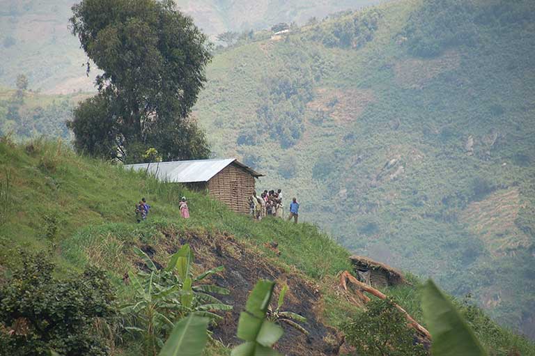
Central Africa covers a large area ranging from desert conditions in the north to tropical rain forests and mountains in the equatorial region of The Congo. The entire region is roughly the same size as the United States west of the Mississippi River. In this textbook, the countries included in the region include Cameroon, Congo, Chad, the Central African Republic, Gabon, Equatorial Guinea, The Congo (former Zaire), Rwanda, and Burundi. Located off the west coast of Central Africa is the small twin island country of São Tomé and Príncipe. Burundi and Rwanda are often included in the region of East Africa, but their connection to The Congo makes them more relevant to the Central African region for the purposes of this textbook.
The equator runs through the middle of Central Africa. Type A climates are dominant in the region, complete with tropical rain forests and jungle environments. In the north is the African Transition Zone, which runs through Chad. In Chad, the arid region of the Sahara Desert transitions into the humid tropics. Central Africa usually only includes portions of Sub-Saharan Africa south of the African Transition Zone. Southern Chad exhibits qualities similar to Central Africa, and the northern areas exhibit qualities similar to North Africa or the northern regions of Niger, Mali, or Mauritania.
The physical geography varies with each country in Central Africa. The most prominent physical landscape is the tropical rain forests of the equatorial region. Highlands can be found in both the western and eastern regions of Central Africa. The Cameroon Highlands are a product of a geologic rift in tectonic plates that created São Tomé and Príncipe, the island portion of Equatorial Guinea, and the mountainous portions of the mainland on the border between Nigeria and Cameroon. There are a number of volcanoes in Cameroon. The only currently active volcano and the highest in elevation is Mt. Cameroon, at more than thirteen thousand feet. Mt. Cameroon emitted a cloud of carbon dioxide in 1986, killing more than 1,700 people. The volcano last erupted in 2000.
Lake Chad in the north is a large, shallow body of water that lies on the border of Chad, Niger, Nigeria, and Cameroon. Lake Chad provides water for local livestock and fishing for millions of people. Its location on the border of four countries has caused political infighting over local water rights, which are valuable commodities in such an arid climate. Climatic conditions and diversion of the lake for human purposes have caused the water to recede. If these conditions continue, the lake might virtually disappear by the end of the twenty-first century, which would have disastrous effects on both the human population around the lake and the biodiversity. Waterfowl, crocodiles, fish, and a host of other creatures depend on Lake Chad for their survival, and its loss would create an environmental catastrophe.
On the eastern border of the Congo is a portion of the Great Rift Valley, which extends from Southern Africa in Mozambique to Lebanon in the Middle East. Lake Tanganyika and Lake Albert are two of the larger lakes along the western section of the Great Rift Valley. Lake Tanganyika is more than 418 miles long and runs the entire length of the boundary between The Congo and Tanzania. These are deepwater lakes. Lake Tanganyika is the world’s second-deepest lake, with a depth of 4,800 feet. Because of its depth, it is also the world’s second-largest lake by volume after Lake Baikal in Russia, which has the record for both volume and depth.
At the heart of Central Africa are the massive Congo River and all its tributaries. It is the deepest river system in the world and has some stretches that run more than seven hundred feet deep, providing habitats for a wide range of organisms and fish species. The Congo River basin is second in size only to the Amazon basin in South America. Home to Africa’s largest tropical rain forest, this region is host to a massive variety of plant and animal species, which create an extensive environmental resource base. Human activity has been encroaching on this valuable environmental region filled with extensive biodiversity. Logging, slash-and-burn agriculture, and civil war have devastated large areas of the Congo basin, resulting in the loss of habitat for many tropical species.
B. Conflicts and Unrest in Central Africa
The two landlocked countries of Chad and the Central African Republic have endured unstable conditions in their transitions to independent, stable democratic states. Chad had been in dispute with Libya over the Aozou Strip bordering their two countries, an area deemed rich in minerals and uranium, but in 1994, Chad was awarded sovereignty over the Aozou Strip by the United Nations (UN) International Court of Justice. Chad was a temporary home for more than 250,000 refugees from the ethnic cleansing campaign in the Darfur region of the Sudan. Thousands more from the Central African Republic sought refuge in Chad. Meanwhile, Chad’s government has been plagued with corruption and mismanagement, a state of affairs that has hampered its efforts to offer humanitarian aid to its refugees. Similarly, the Central African Republic is troubled by a history of unstable and short-lived democratic governments. Military coups and transitional governments are frequent. Civil unrest erupts into chaos. Rebel groups control large parts of the countryside. It is difficult for the people to access reliable public services such as health care, education, and transportation systems when the government is not functioning adequately.
Rwanda has been severely affected by the difficulties typically associated with the transition between colony and independent nation. Ethnic divisions manipulated by the colonial masters erupted to challenge the country’s stability and future. The division between the Tutsis and the Hutus has deep historic roots. In 1994, the centuries-old conflict between the two ethnic groups erupted into violence of unprecedented proportions and resulted in the senseless killing of hundreds of thousands of innocent people. The Hutus amassed large militias and took revenge on the Tutsis for years of oppression. Hutu militias rounded up and killed all Tutsis, moderates, and anyone not supporting the Hutu cause. The killing of hundreds of thousands of people continued from city to city throughout the countryside. Within a few months, the genocide is estimated to have caused the death of as many as a million people.
The atrocities of the Rwandan genocide extended across the population. Men, women, and children were encouraged to kill their neighbors by hacking them to death with machetes. If they refused to comply, they themselves were threatened with death. Victims were herded into schools and churches, where they were massacred and the buildings would be burned to the ground. As people fled the region, the number of Tutsi refugees entering neighboring countries ballooned to more than a million.
Tutsi rebels finally gained strength, defeated the Hutu militias, and ended the slaughter. Fearing retribution for the more than one million Tutsis who had been massacred, more than a million defeated Hutus fled as refugees across the borders into Uganda, Burundi, the Congo, Uganda, and Tanzania. Refugee camps housing thousands of people each were hastily constructed without proper sanitation or supplies of drinking water. Diseases such as cholera and dysentery swept through the camps and killed thousands of refugees. The country of Rwanda was left divided and devastated.
The entire Central African region was devastated by the massive shifts of refugees and the brutal killing of so many people. The competition for the control of resources and the increase in military arms along the Zairian border became a major component of the civil war that plagued the Congo (Zaire) during the same period. Up to five million people died in the Congo because of warfare, disease, and starvation. The wars in the Congo involved military actions by the Tutsis from the Rwandan and Ugandan governments and Hutu militias.
The names of the Democratic Republic of the Congo (a former Belgian colony) and the Republic of the Congo (a former French colony) can be easily confused. At one point after they had become independent, both countries chose the name Republic of Congo. To keep them straight, they were commonly referred to by their respective capital cities—that is, Congo-Leopoldville (the larger eastern country, also known as Zaire) and Congo-Brazzaville (the smaller western country). The larger former Belgian colony has since become simply The Congo, or is referred to unofficially as the Belgion Congo, and the smaller former French colony has become simply Congo.
Two wars in The Congo resulted in the highest number of deaths since World War II. The First Congo War (1996 to 1997) occurred when President Joseph Mobutu was overthrown by militant forces led by rebel leader Laurent Kabila, who was a long-standing political opponent of Mobutu and was backed by Ugandan and Rwandan militant groups. Mobutu was eventually forced from office and fled the country. Kabila declared himself president and changed the official title of the country from Zaire to Democratic Republic of the Congo. This transition in political power caused a shift in the militant rebel groups, which created the conditions for the Second Congo War (1998 to 2003), which was even more brutal than the first. The assassination of President Kabila in 2001 permitted his adopted son Joseph Kabila to take power and run the country up to the present. The total number of deaths resulting from the civil wars in The Congo was estimated in 2008 at about 5.4 million—the majority by the wars and the remaining by disease or starvation.
Armed military conflicts in the Congo did not end with the Second Congo War. Conflicts continue in the eastern region. These armed confrontations are often referred to as the Kivu Conflict because they are taking place in the provinces of North and South Kivu in the Congo’s eastern region along the borders with Rwanda and Burundi. It is estimated that nearly one million people were forced to flee their homes in The Congo in 2016, the largest number of internally displaced people of any country in the world that year. Such conflicts are not widely reported by news outlets in core areas such as the United States.
Understanding that most wars are fought over the control of resources is a major step in comprehending the conflicts in Central Africa. The conflicts in the Congo are likely to continue because of vast caches of mineral wealth in the country that have yet to be extracted. Economic pressure to control the extraction activities of saleable raw materials is often the driving force behind rebel groups in places such as the Congo. Local factions usually sell the raw materials for prices well below market value.
The sale of precious minerals such as cobalt, coltan, gold, and diamonds has helped fund the wars in the Congo. The country produces more cobalt ore than any other country in the world. Cobalt is a valued metal used in aircraft engines, medical implants, and high-performance batteries. The major mining operations for cobalt ore are located in the southeastern Katanga state, where there are also large reserves of copper.
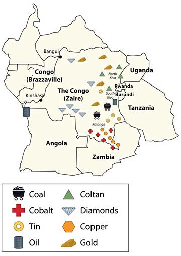
Coltan is a mineral that tantalum comes from, which is highly prized for its use in capacitors for electronic circuits. Tantalum is found in most modern electronic devices in high demand worldwide, from video game systems to cell phones. Most of the coltan in the world comes from mines in the Congo in the eastern Kiva regions. The eastern region is also home to a high percentage of the world’s industrial diamond reserves. Other minerals and ores are also found in abundance in the region. The sale of precious gems and rare minerals can bring huge profits, but the wealth seldom reaches the hands of those that labor in the mines in the extraction process.
Learning about the geopolitics of Central Africa is critical to developing an understanding of how colonial activity gave shape to Central African countries and why multinational corporations are now highly involved in creating the demand and markets for the resources found there. The core economic regions of the world require the raw materials and resources that are extracted from peripheral places such as the Congo to fuel their economic activities and to bring profits to their shareholders. The core economic players in the global markets are also some of the largest arms manufacturers that sell weapons to the local factions involved in the battle for control of the valuable resources. Globalization connects the core to the periphery. In resource-rich places such as the Congo, this relationship is only going become more interactive.
C. The Other Side of Life in Central Africa
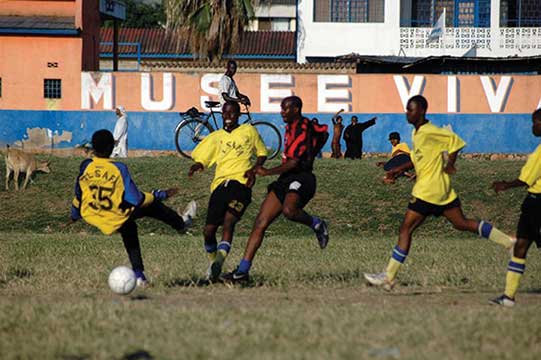
Sports and entertainment seem to be a universal human activity. Football (known as soccer in America) is the dominant sport in the Central African states. Football can be found in even the poorest areas. The low-cost sport is accessible to most citizens of each country. Other traditional sports include wrestling, archery, and track-and-field events. In Chad, for example, a type of freestyle wrestling in which the wrestlers wear animal hides and cover themselves with dust to prepare for the match is widely practiced. Canoe racing can be seen in Cameroon. Board games such as mancala, a count-and-capture African stone game, are also common. Western-style sports such as basketball, baseball, and cricket are played in many of the urban areas. Olympic sports are practiced in countries as skill, ability, and funding provides.
A great variety of cultural traditions spring from the thousands of ethnic groups, distinct languages, and different religious beliefs found in Africa. Cuisine and drink vary as widely as the people’s traditions and are important elements of any celebration or festivity. Every country has its own unique way of promoting and celebrating its cultural diversity. Even poor countries such as Chad possess a rich cultural heritage. Chad has opened its own Chad National Museum and the Chad Cultural Center. Rwanda, with its civil wars and ethnic divisions, still honors its holidays with ceremonies and celebrations. The people of Central Africa find time and energy to celebrate life.
The cuisines of Central Africa can be as diverse as each local population, but they have retained much of their local tastes and flavors based on available ingredients. The slave trade introduced items that are now quite common, such as chili peppers, peanuts, and cassavas. Nevertheless, food preparation is based mainly on traditional methods. Plantains and cassavas are mainstays often served with spicy sauces and grilled meat. Tomatoes, onions, and spinach are common ingredients. Root crops of yams, sweet potatoes, and maniocs are widely served. Fruits and vegetables are popular. Specialty stews are choice entrees that may contain ginger, okra, chicken, and various spices. Bambara is a favorite sugary porridge with peanuts and rice that is common in Central Africa. Traditional meats of chicken, goat, or beef are universal, but wild game such as antelope, monkey, crocodile, or whatever is available is widespread. Fish is a main protein source served with other spicy dishes or dried to be eaten later.

D. The Role of Women
Women’s issues remain a concern in Central Africa regarding social equality, economic development, and population growth. The treatment of women reflects the attitudes and traditions of a society. Attitudes and traditions vary with location and with the cultural heritage of an ethnic group indigenous to a given area. Most of the Central African countries are male dominated, a trend that can be witnessed in local activities or sports, in the construction of the government, or in the sex ratio of the business sector. With an average family size of five or more, few opportunities exist for women to break out of their traditional roles within their culture and receive a secondary education or enter a professional field of employment.
The Central African region has different types of marriages that vary from country to country. Some traditional societies still arrange their children’s marriages, but this practice is becoming less common as tradition confronts more contemporary views. Marriages between two people with different ethnic backgrounds are becoming more widespread in the urban areas. Cities are places where people with diverse backgrounds come together to live and work, which can lead to an increase in mixed marriages. Cosmopolitan areas are also more likely to have connections with outside cultures through media and communication technology and might be more tolerant of diverse traditions.
One of the marriage traditions that exists in regions of Central Africa is polygamy, which is the practice of a man or a woman having more than one spouse. In Africa, as in most places in the world, it is far more likely for a man to have more than one spouse than for a woman to have more than one spouse. Polygamy is practiced in areas where traditional beliefs allow it. Approximately 30 to 40 percent of women in the Central African Republic are in polygamous unions. The law sanctions polygamy as long as spouses are aware of the arrangement and agree to it before they marry.
Women caring for large families do not always have the opportunity to earn an education or obtain the training required for employment opportunities or professional positions. Circumstances shaped by culture, tradition, or economic necessity are not necessarily supportive of women advancing in the private or public sectors. Even if the legal code of the country does not discriminate against women, traditional practices and the social status of men often keep women from making socioeconomic strides. Many societies are male dominated, and violence against women is still common and even accepted in parts of Central Africa.
One of the worst cases of violence and discrimination against women exists in the eastern regions of the Congo, where abuse against women, including sexual violence and rape, is listed by UN humanitarian officials as the worst in the world. The civil wars in the Congo have created a difficult climate for women, often with tragic results. Violence against women has become an accepted practice in some areas. During the Congo wars, women were often raped and taken as slaves to serve the soldiers. If and when the women were released from captivity, it was not uncommon for them to commit suicide. Improvements in health care, education, and child care are needed to improve living circumstances for women and may in turn positively affect population growth in the region.
Key Takeaways
- Central Africa covers a large physical area about the size of the United States west of the Mississippi River. Most of the region is in the tropics and has a type A climate.
- Central Africa is a relatively poor region economically. National wealth has been garnered traditionally from the export of food crops such as coffee or tea but more recently from mineral and oil extraction.
- The civil war in Rwanda in 1994 was the result of conflict between the Tutsi and Hutu ethnic groups. The historic division was manipulated by colonial powers and erupted into brutal violence that led to the death of as many as a million innocent people; nearly as many refugees took shelter in
neighboring countries. - The civil wars in the Congo are based on political control as well as control over valuable resources in the eastern states. The two main Congo wars resulted in an estimated 5.4 million deaths from either direct military conflict or the devastation that resulted through starvation and disease.
- Central Africa resonates with cultural and ethnic diversity. Hundreds of ethnic groups live and work together with a high degree of interaction. Traditional cuisine and beverages such as coffee, tea, or beer can be found throughout the region.
- Women’s issues range from cosmopolitan in the urban areas, where mixed marriages are common, to harsh conditions in which violence and abuse is commonplace. Large family sizes and male-dominated traditions make it difficult for women to transition to positions of equality.
9.5 East Africa
Learning Objectives
- Summarize the physical layout and features of East Africa, including the Great Rift Valley.
- Outline the significance that the wildlife and natural beauty of vast regions such as the Serengeti have for the economic activities of the region.
- Explain how each country in East Africa is different from the others and what geographic attributes they have in common.
- Analyze the affect the African Transition Zone has had on the Horn of Africa.
- Learn how and why the country of Somalia is divided into several political regions and what difficulties Somalia has to contend with.
A. Physical Geography
East Africa is a region that begins in Tanzania in the south and extends north through the great grasslands and scrub forest of the savannas of Kenya and Uganda and then across the highlands of Ethiopia, including the Great Rift Valley. The region also comprises the countries of Somalia, Djibouti, and Eritrea, which are located in the African Transition Zone between North Africa and Sub-Saharan Africa. Rwanda and Burundi are physically in East Africa but are covered in the lesson about Central Africa because of their border activities with the Congo. The world’s second-largest lake by surface area is Lake Victoria, which borders Uganda, Tanzania, and Kenya. (Lake Superior, on the border between the United States and Canada, is considered the lake with the largest surface area.) Lake Victoria provides fish and fresh water for millions of people in the surrounding region. The White Nile starts at Lake Victoria and flows north to the city of Khartoum in Sudan, where it converges with the Blue Nile to become the Nile River. The source of the Blue Nile is Lake Tana in the highlands of Ethiopia.
The highest mountain in Africa, Mt. Kilimanjaro (19,340 feet), is located in Tanzania near the border with Kenya. The second highest peak, Mt. Kenya (17,058 feet), located just north of the country’s capital of Nairobi, near the equator, is the source of Kenya’s name. Both mountains are inactive volcanoes and have permanent snow at their peaks. They provide fresh water, which flows down their mountainsides, to the surrounding areas.
B. The Great Rift Valley
The Great Rift Valley provides evidence of a split in the African Plate, dividing it into two smaller tectonic plates: the Somalian Plate and the Nubian Plate. The Great Rift Valley in East Africa is divided into the Western Rift and the Eastern Rift. The Western Rift runs along the border with the Congo. A series of deepwater lakes run along its valley. On the western edge of the Western Rift are the highlands, which have a series of high-elevation mountain ranges, including the Rwenzori Mountains, the highest in the series. The Virunga Mountains on the Congo–Uganda border are home to endangered mountain gorillas. The Western Rift includes a series of deepwater lakes, such as Lake Tanganyika, Lake Edward, and Lake Albert. Lake Victoria is located between the Western Rift and the Eastern Rift.
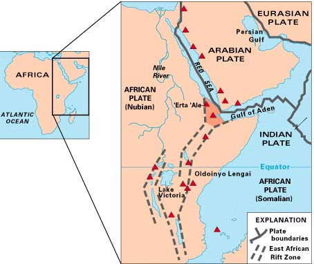
The Eastern Rift does not have deepwater lakes; rather, it is a wide valley or basin with shallow lakes that do not have outlets. The lakes have higher levels of sodium carbonate and mineral buildup because of a high rate of evaporation. The differences in water composition of the lakes along the Eastern Rift vary from freshwater to extremely alkaline. Alkaline water creates an ideal breeding ground for algae and other species of fish, such as tilapia, which thrive in this environment. Millions of birds feed off the abundant supply of algae and fish. Birds attract other wildlife, which in turn creates a unique set of environmental ecosystems. The eastern edge of the Eastern Rift is home to the inactive volcanic peaks of Mt. Kilimanjaro and Mt. Kenya. A number of other volcanic peaks are present in the Eastern Rift, such as Ol Doinyo Lengai, an active volcano.
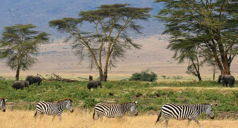
C. Serengeti and Game Reserves
The Great Rift Valley and the surrounding savannas in Kenya and Tanzania are home to some of the largest game reserves in Africa, with a broad variety of big game animals. One of these large regions is the vast Serengeti Plain, located in northern Tanzania and southern Kenya. The governments of Tanzania and Kenya maintain national parks, national game reserves, and wildlife sanctuaries in their countries, most notably in the Serengeti Plain. Legal protection for as much as 80 percent of the Serengeti has been provided. The protections restrict hunting and commercial agriculture and provide protection status for the wildlife. The word Sereng eti means “Endless Plains.”
The Serengeti Plain is host to an extraordinary diversity of large mammals and fauna. The largest migration of land animals in the world occurs in the Serengeti. Every fall and spring, as many as two million wildebeests, antelope, and other grazing animals migrate from the northern hills to the southern plains in search of grass and food.
Dozens of protected areas throughout Eastern Africa have been established in an effort to protect and sustain the valuable ecosystems for the large animals that have found their habitat encroached upon elsewhere by the ever-expanding human population. Kenya has more than fifty-five nationally protected areas that serve as parks, reserves, or sanctuaries for wildlife. The Amboseli National Reserve and Mt. Kenya National Park are two of the more well-known areas. The “big five” game animals—elephants, rhinoceroses, lions, leopards, and buffalo—and all the other unique animals found in the same ecosystems, translate into economic income from tourists from around the world that wish to experience this type of environment. The national park systems in Uganda and Ethiopia have made provisions to provide more sanctuaries for wildlife in areas where the human population is growing and the political situation has not always been stable.
D. Kenya
During colonial times, the British considered the land area now called Kenya to be a Crown protectorate area. The coastal city of Mombasa has been an international shipping port for centuries and is now the busiest port in the region. Persian, Arab, Indian, and even Chinese ships made port in Mombasa during its earliest years to take part in the lucrative trade of slaves, ivory, and spices. Portugal sought early control of the trade center but eventually lost out to Britain. Arab and Middle Eastern shippers brought Islam to the region; Europeans brought Christianity. Hinduism and Sikhism from India found their way into the country with workers brought over by the British to help build a railroad to Uganda. Kenya gained independence in 1963 and worked throughout the latter part of the twentieth century to establish a stable democratic government.
Nairobi, Kenya’s capital and primate city, has become a central core urban area that serves the greater East African region as an economic hub for development and globalization. The largest city in the region, Nairobi is an ever-expanding city that draws in people from rural areas seeking opportunities and advantages. It also has become a destination for international corporations planning to expand business ventures into Africa. Kenya has experienced economic growth and decline as market prices and agricultural production have fluctuated. The Kenyan government has been working with the International Monetary Fund (IMF) and the World Bank to support its economic reform initiatives and reduce waste and corruption in its fiscal processes. The countries of Uganda, Tanzania, and Kenya developed the East African Community (EAC) as a trading bloc to support mutual development and economic partnerships.
Kenya has no one culture that identifies it. There are more than forty different ethnic groups in Kenya, each with its own unique cultural history and traditions. Of the many ethnic groups in Kenya, the Maasai have gained international attention and are often given wide exposure in tourism information. The Maasai are a small minority of Kenya’s population but are known for wearing vivid attire and unique jewelry. Their historical lands have been the border region between Kenya and Tanzania. Cattle, a sign of wealth, have been at the center of Maasai traditions and culture and provide for their subsistence and livelihood. Tourism brings to the surface the diversity of cultures that coexist within Kenya’s environmental attractions, and the country is working to enhance its international draw in the tourism marketplace.
E. Ethiopia
With more than eighty-five million inhabitants, Ethiopia has the second-largest population in Africa; Nigeria has the largest population. Ethiopia was never colonized by the Europeans in the scramble for Africa, but during World War II, it suffered a brief occupation by Italy (1936–41). From 1930 to 1974, Emperor Haile Selassie ruled the country until he was deposed in a military coup. After Selassie was deposed, the government shifted to a one-party Communist state. Successive years in Ethiopia were filled with massive uprisings, bloody coups, and devastating droughts, which brought about massive refugee problems and civil unrest. Famine in the 1980s caused the deaths of more than a million people. The Communist element in Ethiopia diminished when the Soviet Union collapsed in 1991. The country’s first multiparty elections were held in 1995.
The region of Eritrea had been a part of a federation with Ethiopia. In 1993, Eritrea declared independence, sparking a boundary war with Ethiopia that eventually concluded in a peace treaty and independence in 2000. The final boundary is still disputed. The breaking off of Eritrea left Ethiopia a landlocked country with no port city.
The capital and largest city in Ethiopia is Addis Ababa, which is the center for various international organizations serving East Africa and Africa in general, such as the African Union and the United Nations (UN) Economic Commission for Africa. This city is the hub of activity for the country and for international aid for the region.
The Great Rift Valley bisects Ethiopia. Highlands dominate the northwest, and minor highlands exist southwest of the rift. The Ethiopian Plateau encompasses the Northwest Highlands and is home to Lake Tana, the source of the Blue Nile. Elevations on the Ethiopian Plateau average more than 5,000 feet, and the highest peak, Ras Dashan, reaches up to 14,928 feet. The climate includes sporadic rain in early spring. The typical rainy season extends from June to September, but the rest of the year is usually dry. The high elevations of the highlands cause a rain shadow effect in the deep valleys or basins on the dry side of the region. Eastern Ethiopia is arid, with desert-like conditions. The impact of overpopulation on the natural environment has been deforestation and higher rates of soil erosion; thus continued loss of animal species is inevitable. Fortunately, Ethiopia has established natural parks and game reserves to protect wildlife and big game.
Ethiopia has been inhabited by divergent kingdoms and civilizations, giving rise to a rich heritage and many cultural traditions—so much so that Ethiopia is home to eight UNESCO World Heritage Sites. More than 60 percent of the population claims Christianity as its belief system; about 30 percent of the population is Muslim. Many traditional religions prevail in rural areas. In contrast to other African countries, Christianity came to Ethiopia directly from the Middle East rather than from European colonizers or missionaries from Western countries. In Ethiopia, Christianity was structured into the Ethiopian Orthodox Church, a church that has endured through centuries.
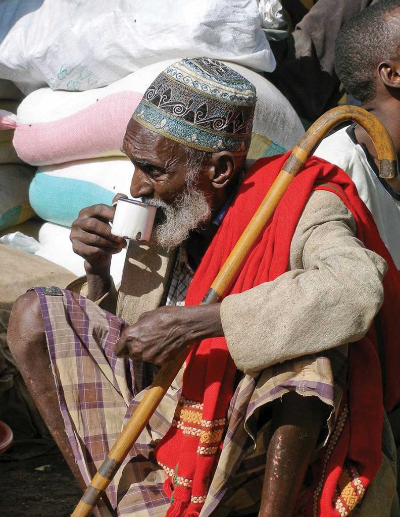
F. Rural-to-Urban Shift
The average family size (fertility rate) in East Africa is about 5.5, which is typical of the entire continent of Africa and translates into exploding population growth. In many areas of Africa in general and East Africa in particular, most of the population (as much as 80 percent) makes its living off the land in agricultural pursuits. Large families in rural areas create the conditions for the highest levels of rural-to-urban shift of any continent in the world. The large cities—with expanding business operations complete with communication and transportations systems that link up with global activities—are an attractive draw for people seeking greater employment opportunities. In East Africa, each of the three largest cities—Nairobi, Dar es Salaam, and Addis Ababa—is more populous than Chicago, the third-largest US city. In West Africa, the city of Lagos, Nigeria, is more populous than New York City and Chicago combined. These cities are all riding the worldwide wave of globalization and are core centers of economic activity for the business sector and
corporate enterprises.
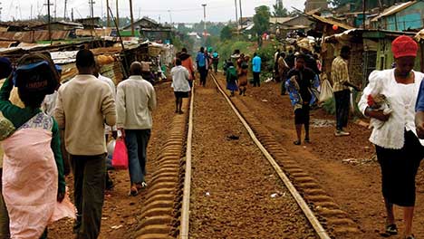
The other regions of Africa all have central cities that act as economic core areas and attract the multitudes from rural areas looking for employment and opportunities. International connections are indicative of local economic development, which is causing the urban areas to grow at exponential rates. Cities heavily affected by a high level of rural-to-urban shift often cannot build infrastructure fast enough to keep up with demand. Self-constructed slums and squatter settlements, which lack basic public services such as electricity, sewage disposal, running water, or transportation systems, circle the cities. All the large cities of Africa are expanding at unsustainable rates. Traffic congestion, trash buildup, higher crime rates, health problems, and air pollution are some of the common results.
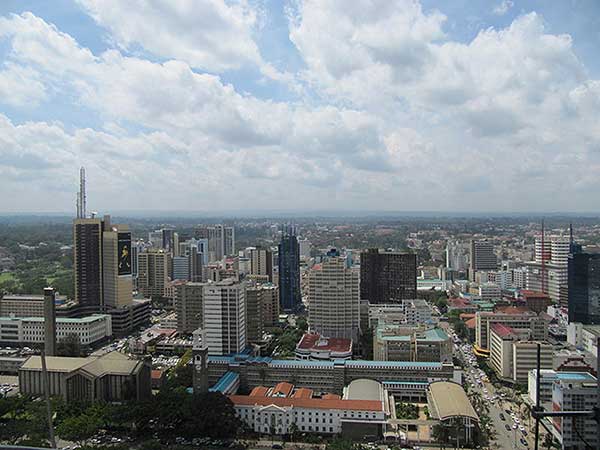
Key Takeaways
- The physical geography of East Africa is dominated by the Great Rift Valley, which extends through the middle of the region from north to south. Associated with the rift valleys are vast savannas such as the Serengeti Plain, large lakes, high mountains, and the highlands of Ethiopia.
- East Africa has extensive habitat for large herds of big game animals, mountains for great apes, and enough prey for the big cats such as lions and cheetahs. Countries are establishing game preserves, national parks, and conservation areas to protect these animals and their natural habitats and to provide economic opportunities to gain wealth through tourism.
- Most of the populations of countries in East Africa earn their livelihood through agricultural activities because the region has a high percentage of people living in rural areas. Large families fuel an ever-increasing rural-to-urban shift in the population, causing the cities to grow at an unprecedented rate.
- Areas along the African Transition Zone have experienced a higher degree of political conflict and civil unrest. Somalia has the highest level of political division and fragmentation based on religion and ethnic backgrounds, which contributed to the secession of the two autonomous regions of Somaliland and Puntland. The central government is neither stable nor strong enough to govern the fragmented country.
- Diversity in the region is remarkably high; there are hundreds of different indigenous ethnic groups, each with its own language and culture. Religious activity is split between Christianity, Islam, and traditional beliefs. Islam is more favored in the African Transition Zone and to the north, while Christianity and animism are more prominent to the south of the zone.
9.6 Southern Africa
Learning Objectives
- Summarize the major physical features of the region and explain the role that natural resources play in the economic activities of the people.
- Outline the differences between the mainland of Africa and Madagascar.
- Determine how ethnicity has played a role in the political situation of each country.
- Understand apartheid’s effect on South Africa.
Southern Africa is the region of the African continent south of The Congo and Tanzania. The physical location is the large part of Africa to the south of the extensive Congo River basin. Southern Africa is home to a number of river systems; the Zambezi River is the most prominent. The Zambezi flows from the northwest corner of Zambia and western Angola all the way to the Indian Ocean on the coast of Mozambique. Along the way, the Zambezi River flows over the mighty Victoria Falls on the border between Zambia and Zimbabwe. Victoria Falls is the largest waterfall in the world based on selected criteria and is a major tourist attraction for the region.
Southern Africa includes both type B and type C climates. The Tropic of Capricorn runs straight through the middle of the region, indicating that the southern portion is outside the tropics. The Kalahari Desert, which lies mainly in Botswana, is an extensive desert region with an arid mixture of grasslands and sand. When there is adequate rainfall, the grasslands provide excellent grazing for wildlife. Precipitation varies from three to ten inches per year. The Kalahari is home to game reserves and national parks. Large areas of dry salt pans stretch over ancient lake beds. The salt pans fill with water after heavy rainfall but are dry the remainder of the year. The Namib Desert, found along the west coast of Namibia, receives little rainfall. Moderate type C climates are found south of the Kalahari Desert in South Africa, where conditions are suitable for a variety of agricultural activities, including fruit orchards and an expanding wine industry.
Madagascar is located to the east of the continent, in the Indian Ocean. Madagascar is the world’s fourth-largest island and is similar in area to France. Surrounding Madagascar are the independent island states of the Seychelles, Comoros, and Mauritius. Madagascar is included in this section on Southern Africa but does not share its cultural geography or biodiversity. The early human inhabitants of Madagascar can trace their ancestry to the regions of Malaysia and Indonesia in Southeast Asia. People from the African mainland also joined the population. The whole island later came under the colonial domination of France but won its independence in 1960.
Madagascar’s unique physical environment is home to many plants and animals found nowhere else in the world. At least thirty-three varieties of lemurs and many tropical bird species and other organisms are found only on Madagascar. It is an area of high biodiversity and is home to about five percent of all the animals and plants in the world. Tropical rain forests can be found on the eastern edge on the windward side of the island. The western side of the island experiences a rain shadow effect because of the height of the central highlands, which reach as high as 9,435 feet. The western side of the island has a smaller population and receives less precipitation.
Since 1990, the eastern tropical rain forest has experienced a sharp decline because of extensive logging, slash-and-burn agriculture, mining operations, and drought. Population growth has placed a heavier demand on the environment, which in turn puts stress on the habitats of many of the unusual organisms that are unique to the island. Typical of many African nations, agriculture is Madagascar’s main economic activity. About 80 percent of the twenty million people who live on the island earn their living off the land. Deforestation is occurring on all parts of the island and is more severe in areas where human habitation leads to a high demand for firewood used in cooking. In other parts of Africa, important environmental areas have been protected or transformed into national parks and wildlife preserves. Though protected areas do exist on Madagascar, efforts to protect the environment and the wildlife have been hampered by the lack of available funding and the population’s high demand for natural resources.
The countries on the Southern African mainland share many of the demographic qualities of the rest of Africa: large family size, agrarian economies, multiple ethnic groups, rural populations, political instability, and a high rate of rural-to-urban shift. Southern Africa is set apart from other Sub-Saharan African regions because of its mineral resources, including copper, diamonds, gold, zinc, chromium, platinum, manganese, iron ore, and coal. Countries in Southern Africa are quite large in physical area, except three smaller landlocked states: Lesotho, Swaziland, and Malawi. The larger countries—South Africa, Botswana, Mozambique, Zimbabwe, Zambia, Namibia, and Angola—all have extensive mineral deposits.
The vast mineral resources make this one of the wealthiest regions of Africa with the greatest potential for economic growth. A physical band of mineral resources in Southern Africa stretches from the rich oil fields off the northwest coast of Angola, east through the diamond-mining region, and into the northern Copper Belt of Zambia. Diamond mining is found in parts of Botswana and along the coast of Namibia. Coal can be found in central Mozambique. Gold and diamonds are mined in South Africa. The countries that are able to conduct the necessary extractive processes are creating national wealth and increasing the standard of living for their people.
B. South Africa
Anchoring Sub-Saharan Africa to the south is the dominant country of South Africa. Its large land area and vast mineral resources support a population of about fifty million people. The Cape of Good Hope on the southern tip of the continent is a transition point from the Atlantic Ocean to the Indian Ocean. Its strategic location was important for the control of shipping during the early colonial era before the Suez Canal provided a shortcut between Europe and Asia. The European colonial era first brought Dutch explorers to the Cape of Good Hope, where they established the city of Cape Town as a stopover and resupply outpost on their way to Asia.
South Africa is home to many indigenous ethnic groups and is demonstrative of the diverse pattern of human geography. The country has a history of both ethnic diversity and ethnic division. Two of the largest African groups are the Xhosa and the Zulu. The European component of the ethnic mosaic was enhanced by colonial and neocolonial activities. After the arrival of the first Dutch ships, other Europeans followed and competed with the African groups for land and control. The discovery of first diamonds and then gold prompted Britain’s involvement in South Africa. The Boer Wars (1880–81 and 1899–1902) were fought between the Dutch-based Boers and Britain for control of South Africa’s mineral resources. South Africa became a British colony dominated by a white power structure. The Boers (later known as Afrikaners) spoke Afrikaans (a Dutch dialect that is now considered a separate language) and were prominent in the South African political system.
Segregation first developed as an informal separation of the racial groups but evolved into the legally institutionalized policy of apartheid, which separated people into black, white, and coloured (mixed race) racial categories. A fourth category was developed for people from Indian or Asian backgrounds. Apartheid eventually found its way into every aspect of South African culture. In the larger scale of society, access and separation was based on race. Each racial group had its own beaches, buses, hospitals, schools, universities, and so on. The legal system divided the population according to race, with the white minority receiving every advantage. There were extensive and detailed rules for every aspect of daily activity, including which public restroom or drinking fountain could be used, which color an individual’s telephone could be, and which park bench a person could sit on. The government also sanctioned separate homelands for people from different ethnic groups. People were physically removed from their homes and transported to their respective new homelands based on their racial or ethnic background. The policy of apartheid not only divided the country at that time but set up racial barriers that will take generations to overcome.
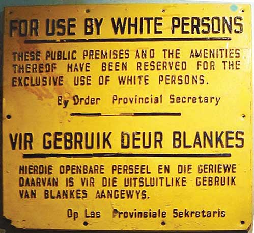
The controversial policy of apartheid in South Africa achieved international attention. Many countries condemned it and implemented economic sanctions and trade restrictions against South Africa. Opposition grew within the country and erupted into violence and social unrest. As a result, the white-dominated government of South Africa began to dismantle the apartheid system in the 1990s. The ban on political opposition parties, such as the African National Congress, was lifted, and after twenty-seven years in prison, Nelson Mandela was released from prison, where he had been held for his resistance activities. The apartheid legislation was repealed, and a new era began. Mandela was the first African to be elected president of South Africa in the new multiracial elections of 1994. His presidency, which ended in 1999, set the stage for a multiracial society. The country is still working through the ramifications of all those years of racial separation. As can be expected, the transition has not been without difficulty.
South Africa has large, modern cities such as Cape Town, Johannesburg, and Durban, each about the size of the US city of Chicago or larger. The cities of Pretoria, East Rand, and Port Elizabeth are also major metropolitan areas and have more than one million people each. These urban centers all contribute to and support the extensive mining and agricultural activities that provide national wealth. As the country that exports more diamonds than any other in the world, South Africa has gained much national income from the extraction of mineral resources, which are being tapped by some of the largest mining operations on Earth.
Much of South Africa has a moderate climate and good soils, which combine to produce enormous quantities of agricultural products, both for domestic consumption and for export. Mining and agriculture have provided many opportunities for employment—opportunities that draw in migrants from neighboring countries with political unrest or poor economic conditions. These immigrants add to the cultural dynamics of an already ethnically diverse country.
South Africa’s manufacturing sector is not well developed. The country depends on Europe, East Asia, and the United States, the three main core economic areas of the world, to provide industrial goods. There are few well-paying manufacturing jobs to provide for a growing or stable South African middle class.
The structure and dynamics of the current economic activities have brought about a two-tiered socioeconomic system. Most of the population may work in the mines, in agricultural activities, or in the service sector, but they are not directly benefiting from the profits of their labor, other than earning a wage. These people find themselves in the poorer working-class majority of the population. The landowners, mining corporation executives, and social elite that control the service sector or are employed in activities such as banking or the commodity markets are receiving higher incomes and have created a wealthier upper class. Apartheid supported this class division. The current free and open legal system has yet to bring about a change in the socioeconomic structure of the population. Millions of poor ethnic minorities find themselves in living conditions similar to their economically depressed neighbors in other parts of Africa, while the wealthier upper class has established a good standard of living similar to that of the core economic areas of the world.
South Africa redrew its internal provincial boundaries in 1994. The large former Cape Province in the south, which had been a former British center of power, was divided into three smaller provinces. The large Transvaal Province in the north, which had been a center for Afrikaners, was divided into four smaller provinces. Orange Free State changed its name to Free State and Natal Province changed its name to Kwazulu-Natal. The changes were made based on the size and political management of the country that had come with the transfer of power when Mandela became president. The European colonial pattern of settlement was adjusted to represent a more South African pattern of political administration.
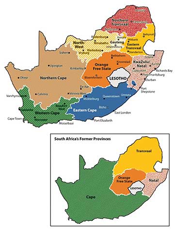
Key Takeaways
- Southern Africa is located along the Tropic of Capricorn and is host to various climate zones, including tropical, desert, and moderate type C climates. Extensive agricultural activity can be found south of the Tropic of Capricorn, where moderate climates prevail.
- Madagascar is a separated from the mainland of Africa and provides a habitat for animals not found on the mainland. The mainland region is large with many different physical landscapes.
- The mainland region of Southern Africa has extensive mineral deposits that provide resources for its countries to gain national wealth. Approaches to translating mineral deposits into wealth have varied among the countries.
- Many ethnic groups can be found in Southern Africa, ranging from the San in the Kalahari to the Zulu groups to the south. Colonialism made its footprint on the region by creating borders and providing colonial names. The transition from colony to independent nation has caused political and economic difficulties.
- South Africa had an apartheid system in place stemming from the colonial era. The apartheid system was dismantled after the 1994 election of President Nelson Mandela. South Africa went so far as to change its provincial system from four to nine provinces to more appropriately politically administer the country.
End-of-Chapter Summary
- Sub-Saharan Africa has many rapidly expanding core cities and large rural peripheral regions that are experiencing high rural-to-urban shift. Most countries are former European colonies that are growing their own economies as developing countries. The hundreds of tribal groups that live there with their own languages and cultures often clash with each other or their government.
- The informal sector is strong in this realm as people seek opportunities amid civil unrest and conflict. The weak formal sector in many countries does not always receive enough revenue from taxes or fees to operate the public sector and provide services to the people. The realm has a high potential for economic development in the extraction of minerals as well as tourism.
- West Africa has many countries with hundreds of separate ethnic groups with their own languages. The high diversity makes it difficult for social unity and political cohesiveness. Located on the African Transition Zone, there is often conflict between the Muslim north and the Christian south. Civil wars in recent years have devastated various countries. Nigeria is the most populous country in Africa with a growing diverse population. In spite of its diversity and issues, Sub-Saharan Africa retains a sense of vibrancy in the celebration of family and community.
- Central Africa covers a large region of tropical Africa, including the vast Congo River basin. Poor economic conditions have been partly a result of the many civil wars and conflicts in the region where the controlling party or military power has received most of the wealth, leaving the majority in need of infrastructure improvements and public services.
- The transition from colony to independent country has often resulted in short-lived unstable governments that were often replaced with leaders who took advantage of their power to place large amounts of public funds in their own foreign bank accounts. Such fraud and corruption have often left most of the people with fewer opportunities and little money left for public services.
- The civil war in Rwanda, which was based on ethnicity, led to as many as a million deaths. The civil war in the Democratic Republic of the Congo over the control of land and resources resulted in more than five million deaths, the most of any war since World War II. Hundreds of ethnic groups exist in an area that is being exploited for valuable mineral deposits.
- Large deposits of gold, diamonds, and rare minerals such as coltan are located in the Democratic Republic of the Congo and surrounding areas. The wealth that they can generate has fueled many armed conflicts by various groups that vie for control of these resources. Women have suffered serious setbacks in their rights and status in Central Africa because of these conflicts.
- East Africa is dominated by the Great Rift Valley, with its large lakes, high mountains, and vast savanna plains. The Serengeti and other game preserves are home to immense numbers of big game that are attractive for tourism. Most of the people work in agriculture. Diverse ethnic and religious groups exist here, and there is a high rural-to-urban shift in the population. Somalia is divided, with various major factions controlling parts of the country.
- Southern Africa, located on the Tropic of Capricorn, has moderate climates and extensive mineral deposits. The countries have a positive means to gain wealth from agriculture and minerals. There is a high diversity of tribal groups that have been impacted by colonial activity. South Africa had an apartheid system for years that finally broke down in the past few decades. Zimbabwe is an example of a country that has been devastated by dictatorial rule by one man for many years without democratic reforms.
- Madagascar is a large island off the east coast and has different flora and fauna from the mainland because of isolation by tectonic activity. The island of Madagascar was once connected to the African continent but drifted away with the activity of the tectonic plates in that area. The biodiversity on Madagascar is jeopardized by the high level of deforestation that is destroying the habitat for rare animal species.