6
Learning Objectives
- Describe how cities originated and developed
- Explain how modern cities impact their surrounding areas
- Analyze the internal structure of cities
- Identify the key features of urban infrastructure
- Discuss the challenges facing modern cities
If you could live anywhere, where would you live? Would you rather live in a rural area, alongside farms and rolling fields, or in a city, bustling with activity? What advantages does each of these locations have, and why do you think people ultimately choose to live where they do? This chapter explores urbanization, from the origin and development of the earliest cities to the modern challenges facing urban areas today. We’ll also explore patterns found within urban areas as well as the rise of the suburbs.
6.1 The Origin, Development, and Distribution of Cities
So before there were cities, where did people used to live? When we were hunters and gatherers, we mostly lived nomadic or semi-nomadic lifestyles in relatively small groups, with access to reliable food sources a limiting factor on the size of our population. As we began to practice settled agriculture, we were able to sustain larger populations and bigger villages started to emerge. It’s unclear exactly why cities began to form. Certainly, the practice of settled agriculture was necessary, but cities themselves may have developed as centers of trade, ritual centers related to religious practices, or central locations to store surplus agriculture products. The earliest known city was Çatalhöyük, established in 7100 BCE and located in modern-day Turkey. It was home to around 5,000 to 7,000 people. Other cities emerged, including Uruk in ancient Sumer (modern-day Iraq) with 40,000 people; Memphis, the ancient capital of Lower Egypt, home to around 30,000; and Yin, China, a massive capital city that housed somewhere between 50,000 and 150,000 people. Rome would be the first city to reach 1 million people during the second century CE. Where cities developed was highly dependent on local geography. Access to resources, and water, were critical, and we see that even today, only around 10% of the world lives more than 10 km (6.2 miles) from a body of fresh water.
Where cities emerged and grew was related to the site and situation of particular locations. Site factors were those related to the actual location of a city that made it favorable for people to settle there and for the city to grow and develop further. Things like access to freshwater, arable soil, proximity to a coastline or harbor, natural protective fortifications like cliffs that enabled the city to more easily defend itself from intruders – all of these site factors contributed to where a city might emerge. Situation factors, on the other hand, related to where a city was located in relation to other places. Maybe a city was located in the relative center of a larger region of farmers, or a city might be located closer to its friendly neighbors – or in a relatively remote area to be protected from hostile neighbors. Select a few ancient or long-standing cities and look at maps of where they are located. Where are the nearby rivers? What is the terrain like? What other cities or developments are located nearby?
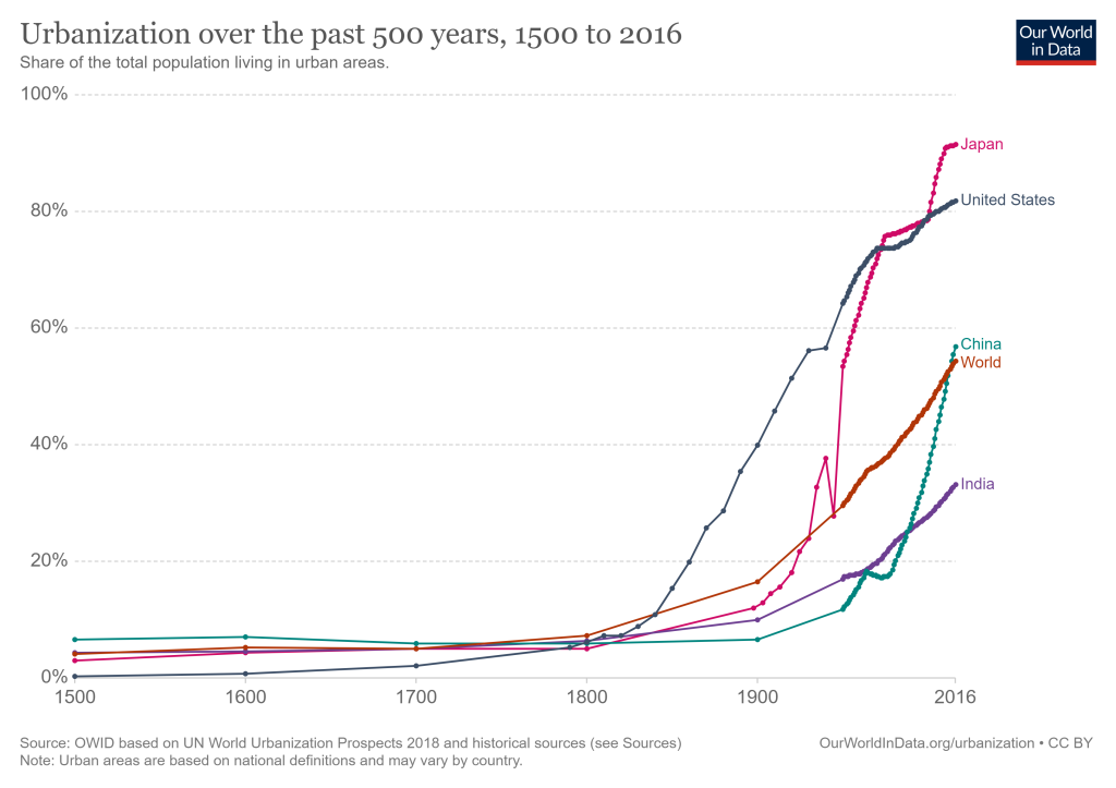
As cities grew and developed, more and more people moved from rural areas to be closer to the cities. Urbanization refers to this process of the population shifting from rural areas to urban ones. In 1800, only around 3 percent of the world lived in urban areas, but over the past 200 years, urbanization has accelerated rapidly (see Figure 6.1). What was driving this change? Consider the broader societal changes that were occurring beginning in the mid-1800s. As industries developed, these jobs were primarily located in cities. Coupled with this, the agrarian revolution meant that fewer farmers were needed in rural areas. Thus, more and more people moved to the city to find work. Urbanization continues today mostly driven by economic factors. In some cases, the city provides an economic pull through the promise of increased job opportunities and higher wages. In other cases, economic downturns and limited opportunities in rural areas essentially push residents to leave. In still other situations, people may move to cities to have access to more services and amenities. Globally, 55% of the world’s population now live in urban areas and that is expected to increase to 68% by 2050, according to the United Nations.
Geographers often refer to the center of an urban area as the central business district, or CBD. In some cities, this might be called the “downtown” area. Here, we find a dense cluster of consumer, business, and public services. Transportation networks are also typically centered around the CBD. Think about your hometown. Where might its central business district be located, and what kinds of businesses are located there? How have the CBDs near you changed over time? Since many businesses seek to locate in the CBD, and land is relatively scarce, real estate prices are typically high. In some cases, this leads developers to build up – creating skyscrapers that maximize the number of tenants with a limited footprint on the ground.
There are a number of principles that govern where cities are located. Central place theory helps explain the spatial distribution of cities across the landscape and their relationship with smaller settlements. Geographer Walter Christaller developed this concept in the 1930s and the basic principles still hold true today. Imagine a flat, homogeneous landscape. Then, imagine that all of the people in that landscape are evenly distributed, and resources are evenly spread out as well. Also imagine that all of the consumers have the same income level and shopping habits. (This is getting less and less realistic, but it’s just a model so stay with it.) Naturally, businesses would tend to locate in a central area to have maximum access to consumers, right? Even when cities were first developing, we saw these central places begin to emerge. As the central place within the region gets bigger, it tends to offer more goods and services and become more specialized. These large settlements also tend to be located farther from other large settlements. We can visualize central place theory using a pattern of hexagons, since they can nestle without gaps and the edges are roughly equidistant (see Figure 6.2). In such a landscape, there lots of small villages (sometimes called lower order places) that offer a few basic goods and services, several towns (or intermediate order places) where you’ll find more options for goods and services, and relatively few cities (or higher order places) where you’ll find lots of specialized goods and services – things like major higher educational institutions, international airports, large financial centers, and so on. Think of a big city near where you live. What goods and services does it offer? Are there smaller towns and even smaller villages that surround it? Even though the model might not fit exactly, it’s a good way to visualize how cities and smaller settlements are distributed.

The notion that there is generally a hierarchy of cities in terms of their sizes (in terms of population, not geographic size) within a country can also be explained by the rank-size rule. The rank-size rule is less of a “rule” and more a way of analyzing how the population of cities within a country is distributed. If a country follows the rank-size rule, then the population of the nth largest settlement will have 1/n of the population of the largest city in that country. In other words, the 3rd most populous city in a country would have a population that is 1/3 that of the largest city. Berlin, for example, has a population of around 3.5 million. The second largest city, Hamburg, has about 1/2 the population with 1.8 million residents. Frankfurt, the 5th largest city, has a population around 1/5 that of Berlin with over 730,000 people. Does the rank-size rule hold true in every case? No, and in fact, there are numerous exceptions even within the same country. Munich, for example, is the third largest city in Germany but its population is 1.45 million where it would be hypothesized to be only around 1.2 million if it followed the rank-size rule. The rank-size rule can be a helpful baseline to explore and compare the distribution of cities within a country and to see which areas follow the pattern and where (and why) there are exceptions.
Some countries have a largest city that is far more populous than the next largest city. These are known as primate cities. A primate city is the largest city in a country that is more than twice as populous as the next largest city and is emblematic of the national culture. Not all countries have primate cities. One mental exercise to consider whether or not a country has a primate city is to try and think of the largest city within a country, and then try and think of the next largest city. For example, what’s the most populous city in Greece? Athens, right? You probably thought of that relatively quickly. What’s the second largest city? Having a harder time? It’s Thessaloniki, with a population just under half of Athens. If you can easily think of the largest city in a country but have a hard time thinking of the second largest city, you could just need to brush up on your geography, but it’s more likely that it’s because the country has a primate city. Mexico City, Paris, Cairo, Bangkok, and Jakarta are all considered primate cities.
Do all countries have a primate city? Berlin, as mentioned, is the most populous city in Germany, with a population almost double that of the second largest city of Hamburg. But Munich has increasingly become Germany’s cultural center, so Berlin is generally not considered to be a primate city. Shanghai is China’s most populous city, with over 26 million residents, but Beijing has over 21 million. China has a number of very large cities, in fact, and does not follow the rank-size rule. The United States similarly does not have a primate city, since the entire New York City area is quite populous, but the population of the greater Los Angeles area is more than half the size.
Why do some countries have primate cities and others do not? In some cases, primate cities have emerged as a result of colonization. If an area was colonized, typically the colonial power dominated a single city in the region, perhaps one that was centrally located or had strategic importance, such as a port city. Most of the development and infrastructure was singularly focused on that city, and so even after colonialism ended and the country gained independence, that city retained its primacy. Lagos, for example, was annexed as a colony of Britain in 1861 and once Britain gained control of all of Nigeria, it became the colony’s capital. Transportation and communication infrastructure was centered on the port city. Even though Nigeria is now independent and the capital city was moved to Abuja, Lagos has a population of over 8 million people – almost three times as much as the second-largest city of Kano – and is a major financial center and seaport. In other cases, as industrialization occurred, and urbanization followed, industries may have been concentrated in only one or two areas within a country and a primate city emerged as a result of masses of people moving from the rural areas to the central city to find work. Still other cases represent a combination of factors, with a historic city perhaps gaining prominence during colonization and then continuing its primacy as a result of industrialization and globalization.
6.2 Cities in the Modern World
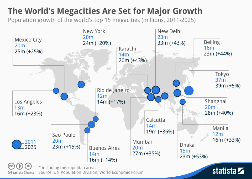
Today’s cities are highly globalized and interconnected, and they’ve continued to grow in size. From the time cities first developed to the first city reaching 1 million residents took around 7,200 years. It would take less than 2,000 more years for the first city, New York City, to reach 10 million residents, and now over 30 cities have a population greater than 10 million. These very populous cities are known as megacities, typically defined as cities with a population over 10 million people. Megacities resulted from the process of urbanization and much of the growth of megacities is in developing countries (see Figure 6.3). Asia, for example, is expected to be home to 30 megacities alone by 2025, and Africa is projected to have 14 within the next 30 years. Why are megacities growing in these regions? As mentioned earlier, the combination of limited economic opportunities in rural areas coupled with economic growth in urban areas has fueled a rural exodus. But, this rapid urbanization has brought about considerable challenges, as we’ll explore in a moment.
As cities have grown, they’ve also become a bit more difficult to define. If I asked you, “What is a city?” what would you say? Perhaps a built up area. Or an area with lots of businesses. Maybe you’d say it’s the CBD. But exactly how big is big enough to be called a city? How many businesses is enough, and what if businesses are located near the city but not in the city? And how much of the area around the CBD does the city include? There are lots of different ways of defining a city and many of these definitions overlap. Have you ever seen a road sign stating “Now leaving” a certain city, and thought to yourself, “I’m pretty sure I’m still in that city…”? These city limit signs refer to the defined boundaries of a city. Within the United States, this is the boundary where the local government has control (including taxation, regulation, and services.) Outside of the city limits are typically unincorporated areas, which might be administered as part of a county or state.
But the legal and administrative boundaries of a city don’t often correspond exactly to where people actually live and work. Very often, people live just outside the city boundary but may commute for work. Businesses similarly may locate near a city to take advantage of its proximity to markets and workers but not be located within the exact city limits. Thus, it is often more helpful to think about “urban areas” rather than the strict boundaries of a city. An urban area includes a central city and the developed region surrounding it. The United States Census specifically defines an urbanized area a region with a population of 50,000 or more people, and an urban cluster referring to an location outside of an urban area that is home to 2,500 to 50,000 people.
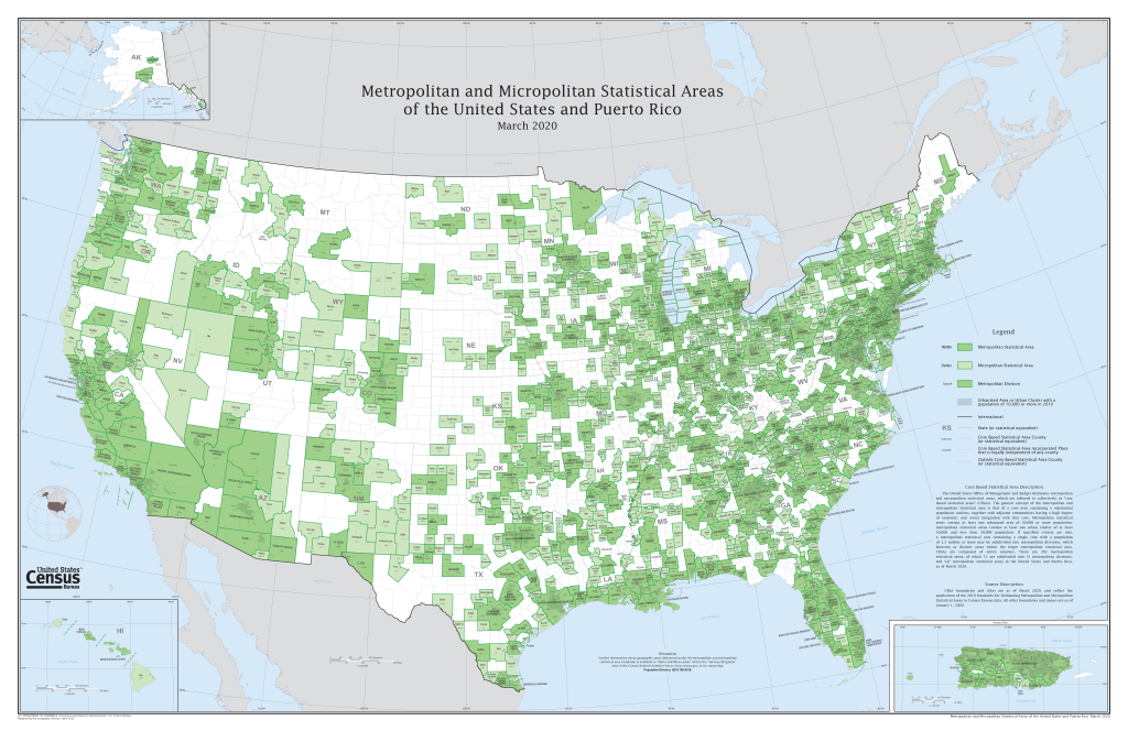
Even urban areas, though, don’t capture the entirety of a city’s impact on the surrounding region. Workers may live outside of an urban area, but still be close enough to commute to the city for work. Thus, the U.S. Census created a specific designation known as a Metropolitan Statistical Area, or MSA, to more precisely capture the boundaries of a city and its impact on the larger region. An MSA contains at least one urbanized area, as defined above, the county where the urbanized area is located, and surrounding counties where a high percentage of residents commute to the central area for work. Micropolitan Statistical Areas are similar but apply to urban clusters. As of 2020, there were 384 metropolitan statistical areas and 543 micropolitan statistical areas in the United States (see Figure 6.4).
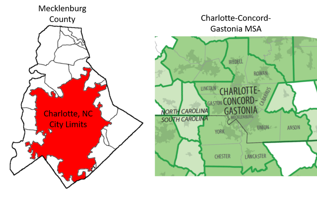
How do all these definitions actually work in practice? As an example, the city of Charlotte, North Carolina, is home to over 885,000 people living within its city limits. However, many people live just outside of the city and commute for work, so over 1 million people live within Mecklenburg County as a whole. But Charlotte is so big and built up that its reach actually continues outside of its county boundaries, with people living in the counties surrounding Mecklenburg and commuting to the county. Thus, the boundary of the larger metropolitan area (known as the Charlotte-Concord-Gastonia MSA) extends far beyond Mecklenburg County – and reaches so far, in fact, that it actually extends over the border into neighboring South Carolina (see Figure 6.5).
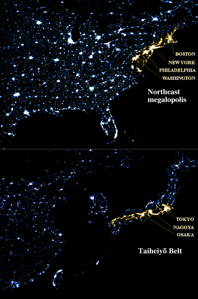
In fact, there are a number of cities around the world that have grown so large that they overlap with other large cities. This is called a megalopolis and they are relatively easy to spot using nighttime satellite imagery (see Figure 6.6). If you’ve ever traveled in the northeastern United States along the Interstate 95 corridor, you’ve likely run into considerable traffic at times (or the entire time) and noticed a relatively continuous built-up area. This megalopolis stretches from the Northern Virginia suburbs of Washington, DC all the way to Boston. It is the most populous megalopolis in the United States with over 50 million residents. The most populous single metropolitan area in the entire world is the Tokyo metro area, with over 37 million residents. It is part of the Taiheiyō Belt megalopolis, also known as the Tōkaidō corridor, stretching along the Pacific coast of Japan from Fukuoka to Tokyo. Over 74 million people live in this region.
Today’s modern, sprawling cities have also spawned new forms of development – and have been accompanied by new challenges. At the beginning of the chapter, you were asked if you wanted to live in a rural area, with more space between you and your neighbor and less housing density, or in a city, with a higher density and more amenities. Throughout the past several decades, however, people have answered that question with, “Can I have both…?” and have chosen to live in suburbs. Suburbs are areas just outside of cities or towns that aim to offer the best of both worlds for residents – proximity to the city for work or education or entertainment, and lower housing density for more affordable, larger homes. Over half of the population of the United States describes their neighborhood as “suburban.” Suburban communities essentially offered the lower cost housing of rural areas, with larger lot sizes and more space between neighbors, and the close proximity to urban areas, usually near major highways or transit lines. For some, suburban communities also promised lower crime rates than central cities. In addition, since property taxes fund school systems, the stable, relatively high property tax bases of the suburbs tended to support better schools compared to cities, which may have some high income residents but also many lower income residents.
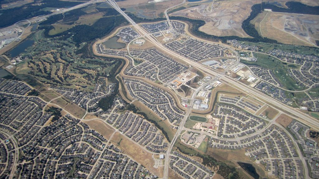
Suburbanization, though, led to a number of distinct challenges. One is sprawl. Urban sprawl is essentially just what it sounds like; it refers to the unrestricted growth of urban areas over large tracts of land (see Figure 6.7). “So what?” you might say. “The United States is huge! Why shouldn’t we spread out?” While the U.S. does have a relatively large land area, the sprawling pattern of the suburbs and the increasing distance from the city center makes transportation planning quite difficult. Imagine you were planning bus lines in a city where most workers commute to and from the central business district. You would likely set up the transit lines in a nodal arrangement, with the CBD as the central node and lines extending outward – and this is how most city’s transportation systems were historically arranged. But how do you develop bus and rail lines when there are many disconnected neighborhoods far from the city center, and workers might work in all different regions of a sprawling urban area? This becomes much more difficult.
It also points to a larger process that has occurred in urban areas and that is urban decentralization. When cities were first developing, most of the goods and services were exchanged in the CBD, and thus most people worked in the center city. If you’ve ever talked to an older, longtime resident of a city, they might recall when the downtown had numerous department stores or a factory. The central business district was very much the central business district. Now think about your hometown or a city you’ve lived in. What is the CBD like today? Or put another way, if you needed to shop for clothes or wanted to buy an appliance, where would you go? Your CBD might still have small clothing stores or a family-owned appliance shop, but it’s increasingly likely that you’d shop at a large mall or superstore outside of the CBD. As these stores have moved away from the CBD, it’s led to decentralization. Our jobs, too, have decentralized as a result of deindustrialization. When industrialization was driving the growth of cities, factories tended to locate relatively close to the city center, in close proximity to workers’ homes. Now, though, people in developed countries tend to work in more service-oriented jobs and the relatively higher cost of land near the city center led businesses to locate farther away. Furthermore, if more and more people are living in the suburbs, a business wanting to be closer to workers might choose to locate nearer to the suburbs rather than nearer to the center city. Think about closest city to where you live and where most people work. Are these businesses located in the historic “downtown” area or near the outskirts of the city? These processes have dramatically changed the way our cities are structured.
6.3 The Internal Structure of Cities
People are not distributed randomly within an urban area. Rather, they tend to concentrate in particular neighborhoods depending on socioeconomic characteristics. Businesses, too, do not locate randomly, but instead tend to cluster so as to be in close proximity to markets while at the same time, minimizing costs. There are a number of models that can help explain this internal structure of cities.
The concentric zone model was developed by sociologist Ernest Burgess in the 1920s and was first applied to the city of Chicago. Burgess found that urban land use could be characterized by concentric rings extending outward from the CBD (see Figure 6.8). Surrounding the CBD was a ring of factories transitioning into mixed commercial and residential, then a ring of workers homes, a ring of more expensive homes, and finally a higher class ring of commuters. While there are some cities that still resemble this model, advances in transportation technologies and deurbanization has changed our urban landscape considerably. In addition, while this model described historic Chicago quite well, it was less applicable to other cities around the world, particularly cities in Latin America.
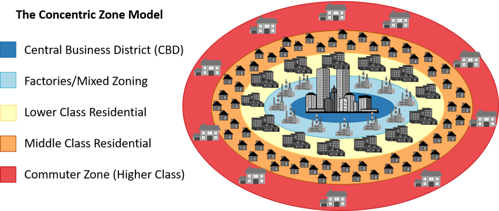
One key principle behind the concentric zone model is bid-rent theory, and you’ve probably encountered this theory in your own life. Essentially, the theory states that the price and demand for real estate decreases as the distance from the city center increases. Everyone in the city, both residents and business owners, are competing for the same land and the amount they are willing to pay is known as “bid rent.” The land that is in highest demand is located close to the CBD, since it offers access to more consumers, and so business owners and residents will pay higher prices to be nearer to the city center. While you might expect to find the poorest housing on the outskirts of the city, it is a trade-off between the size of your home and proximity to work, and thus we often find very large homes far from the city center, where people can afford to commute, and smaller apartments close to the city where residents can more easily get to work. Think about the places you’ve lived and home prices or rent costs, and consider how prices change with proximity to the city center.
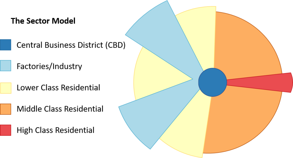
In the late 1930s, economist Homer Hoyt developed the Hoyt model of urban structure, often known as the sector model. In the sector model, zones of development and residences extend outward from the CBD in wedges, like slices of a pie (see Figure 6.9). Why would these wedge-shaped corridors develop? In the concentric zone model, few people had cars, so most workers needed to live close to where they worked and factories needed to locate close to markets. As rail transportation developed, factories, businesses, and even residences could locate along to rail and streetcar lines.
As cities continued to expand, and as cars became more prevalent, the internal structure of cities shifted. Urban decentralization in particular meant that cities had not just one zone of businesses, but often several. The multiple nuclei model was developed by geographers Chauncy Harris and Edward Ullman in 1945 to describe a city that has nodes or nuclei of smaller CBDs on the outskirts of a city (see Figure 6.10). This more complex model helped explain how each smaller CBD would spur growth around it, and how clusters of industry or light manufacturing might develop away from the city center. Harris also created a revision of the multiple nuclei model known as the galactic, or peripheral, model. In this model, a circular highway surrounds a central city and its residential suburbs and various shopping areas and industries are positioned along the ring of highway, looking a bit like planets orbiting a central star (hence the name of the model.)
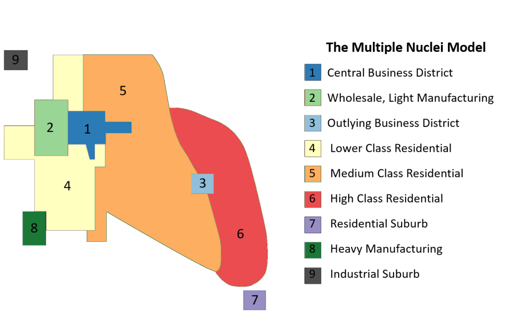
So which of these models is most accurate? It depends on the city. Some cities do seem to have concentric rings of development, though the rings might be different from the ones theorized by Burgess. Other cities have wedge-shaped corridors of development, and these wedges might even align with more modern forms of transportation like interstates or highways, or even high-speed rail lines, so they look similar to the model developed by Hoyt. Still other cities have several clusters of businesses outside of the traditional city center, so they look more like the model created by Harris and Ullman.
Furthermore, all of these models were created by American geographers largely describing cities in the United States. In other parts of the world, we find very different city models. In Southeast Asia, for example, we often find cities that extend from a port zone, reflecting a city structure that was historically centered around exports. Connected to the port zone might be wedges of development such as a commercial zone, and rings of residential developments. Similarly in Latin American cities, we find wedges of commercial, shopping, and higher class residential developments as well as rings of middle class homes and lower class residences. In many African cities, there are clear remnants of colonial development. African cities often have multiple CBDs in the center city: a colonial CBD with a rectangular street network, a traditional CBD with narrower streets and small shops, and a market zone filled with open-air markets. Surrounding the center city are often rings or sectors of manufacturing and ethnic neighborhoods. Ultimately, it’s less useful to try and generalize all American cities or African cities with one model. Instead, it’s a better exercise to simply examine the structure of a city or a few cities within a region and look for patterns. Do most cities seem to have rings of development? Are most cities centered around ports? Where do the wealthy residents live? The poorest residents? Where do most people shop? Are these corridors of development aligned with lines of transportation? These are important questions to consider as human geographers.
The process of suburbanization and urban decentralization has also created new forms of land use such as edge cities and exurbs. Edge cities are urban areas that have a cluster of businesses, shopping, and entertainment located outside a traditional CBD. You can see how edge cities might emerge by examining the multiple nuclei or galactic city model. Essentially, as suburban communities develop, a few key businesses may wish to locate near these residents. Then, maybe a grocery store or shopping area opens up. The suburb continues to grow and eventually a larger business or shopping mall opens. Eventually, what was once a small suburb of people commuting to the central city for work has become its own little (or not so little) city – and businesses may even choose to locate here to be closer to workers rather than locating in the traditional city center. Some of these suburban developments grow so fast, they are known as “boomburbs,” and their populations may eclipse those of the central city. Exurbs may also emerge that are considerable distances away from the city center, often in more rural areas, but near enough to transportation lines such as highways so that residents can commute for work. These areas have lower population densities and, unlike edge cities, offer fewer services and amenities.
6.4 Urban Transportation and Infrastructure
If you wanted to get to school, and did not own a car, how would you get there? Are you within walking distance or could you ride a bike? If you could walk or bike in theory, would it be a safe journey, with sidewalks and dedicated bike lanes? What if it’s located farther away – is there a bus or other mass transit route that could connect you? As mentioned, the increase in suburbanization and urban decentralization has made developing urban infrastructure difficult.
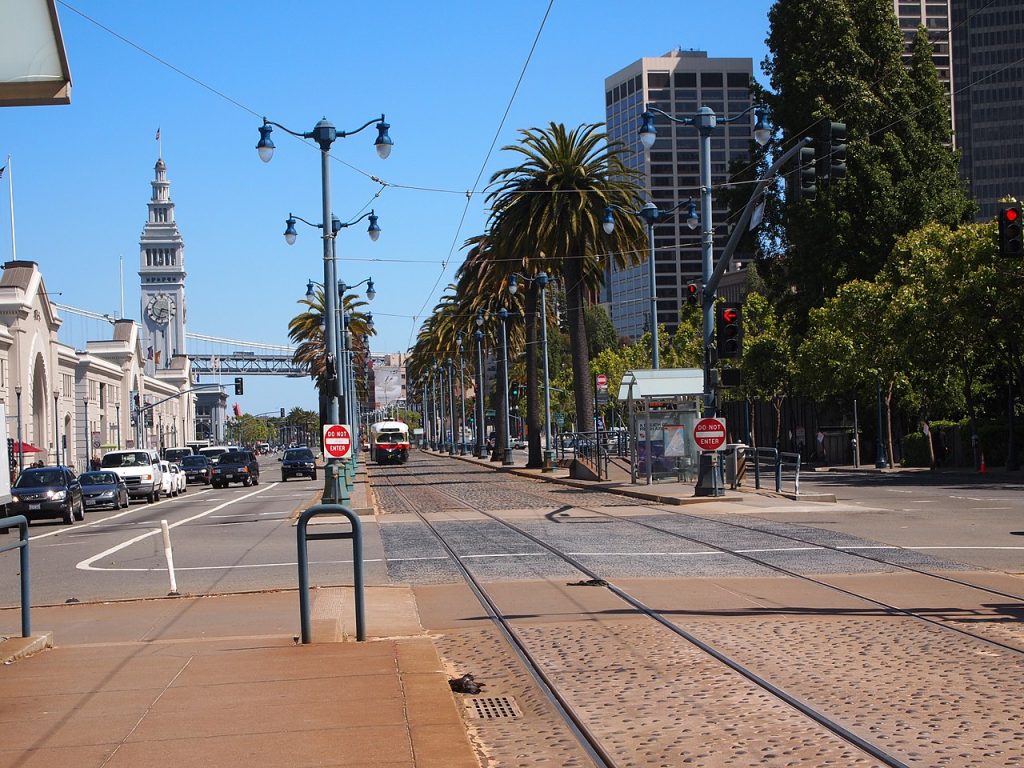
The United States is heavily car-dependent, with 91% of people commuting to work using personal vehicles, according to the Bureau of Transportation Statistics. The vast majority of daily trips, 87%, are also completed using personal vehicles. But who pays for the roads personal vehicles use each day? Around half of U.S. road spending comes from fees directly paid by drivers, such as gas taxes, tolls, and so on. The rest comes from general tax dollars. Thus, the U.S. government encourages the use of personal vehicles through subsidizing its costs. The extensive investment in roads, and the creation of interstate highway systems, dramatically changed our urban landscape. In the 1950s and 60s, the building of the new Interstate Highway System in the U.S. ultimately displaced many communities within central cities, disproportionately impacting Black residents. Some highways cut right through the middle of neighborhoods, disconnecting areas from each other. Furthermore, the highway system privileged some cities while marginalizing others. If you travel along historic highways in the U.S., you can see many old motels and restaurants, some that have since been abandoned. For cities along Interstate Highway routes, however, you might see exit areas bustling with development. To try and address some of the detrimental effects of urban highway construction, some cities have called for their removal and relocation. The Embarcadero Freeway in San Francisco, California, for example, was demolished and instead a multi-use transit route was created with both automotive traffic lanes and a street-car line (see Figure 6.11).
Some cities developed mass transit systems as more sustainable ways to move workers around an urban system, and a way to ensure that residents without cars would still have access to goods and services. Mass transit is less harmful to the environment than private vehicles, with cars emitting far more carbon monoxide and volatile organic compounds than public transit vehicles. When cities were more nodal, with most development in the central business district, these mass transit systems were able to efficiently bring workers into the city center at the beginning of the day and return to their homes in the evening, but their development has often not kept pace with urban decentralization and sprawl. Often, residents must switch trains or buses multiple times to be able to reach their final destination. Another challenge with mass transit is that ticket prices, as with gas taxes and toll expenses, do not fully cover the cost to operate. However, raising ticket prices would ultimately mean that those low income residents who are in most need of utilizing mass transit will not be able to use it, and overall ridership will decrease as the cost to ride increases.
Within the United States, public transit systems are often difficult to get to without walking or driving first, buses and trains are often infrequent (so if you miss one, you have to wait a considerable amount of time), and hours may not coincide with when people need to travel. Comparing this experience to public transit in Europe, you’ll find that new cities and suburbs often developed around mass transit stations (rather than along highways as in the U.S.), so thus the mass transit lines were built first, and then residences and businesses followed. This model is far more cost-effective than trying to re-route existing transit lines to serve new suburbs. European public transit, and public transit systems in most other parts of the world, is generally far more frequent and available at longer hours than in the U.S. In addition to extending hours and adding trains, another strategy to make better use of existing mass transit lines is to invest in more feeder buses that can connect neighborhoods to existing transit stations.
Developing sustainable urban infrastructure is more than just transportation, however. Cities are increasingly encouraging green building or green construction, meaning constructing buildings in an environmentally responsible way. These buildings might include more energy-efficient lighting systems, efficient water systems, and systems for reducing waste. Sustainable urban infrastructure also includes things like greenspaces and parks. While you might view these simply as nice amenities, they can also serve important purposes, such as holding water and preventing flooding during rain storms, and improving urban air quality. Even within the area of transportation, cities are turning to building more walkable communities and ensuring that new road construction includes dedicated bike paths or mixed-use trails.
6.5 Urban Challenges
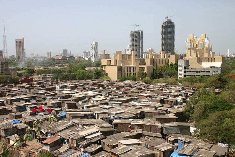
Our rapidly changing, often sprawling urban landscape has brought about considerable challenges. Perhaps the most significant issue globally is that the rapid rural-to-urban migration that occurred within many developing countries has not kept pace with urban housing. Globally, around 1 billion live in slums, an astoundingly high number that is a direct result of rapid urbanization and population growth (see Figure 6.12). Those who live in slums are often known as squatters, meaning they do not own or pay rent on the land they occupy (known as “squatting.”) Slums reflect a lack of affordable, low income housing and while the specific features of slums vary around the world, they typically have a lack of or inadequate public infrastructure, to include clean drinking water and sewer services. Slum areas used to exist within the United States and Europe as well, but affordable mass transit systems and investments in public housing largely eliminated larger slums in more developed countries. The United Nations has made it a goal to provide access to adequate, safe, and affordable housing and provide basic services for all people by 2030, though this will take considerable planning and investment.
One unique way to ensure urbanization keeps pace with the development of affordable housing is to slow the process of urbanization itself. Bhutan, for example, has taken an approach that seeks to prioritize gross national happiness (GNH) over economic growth. Think about why so many people flock to the cities. They are generally in search of economic opportunities and access to more services, right? Well, what if a country could provide some of those services and ensure economic prosperity to those living in rural areas? And what if a government planned urban development in a decentralized way, to prevent all of the economic activity (and migration) from being centered on a single urban area? Bhutan’s government has taken this approach, aimed to create a more sustainable path to urbanization.
More broadly, this notion of intentionally planning for the growth of cities can be termed “smart growth,” in contrast to the sprawling urban developments that would otherwise occur unchecked. With smart growth, a city has well-defined boundaries, a mix of residential and commercial buildings, and a focus on reducing the need for cars through sidewalks, bike lanes, and affordable public transportation. Smart growth is beneficial to lower income workers because it reduces the need for cars and the expense of commuting. It also reduces greenhouse gas emissions significantly.
A lack of affordable housing is not limited to developing countries, however. Even in the United States today, well over half a million people on average are homeless on a given night and around 1.5 million children experience homelessness each year. Rents for low wage workers can often far exceed wages in urban areas, and as mentioned, access to public transit systems outside the central city may be limited. Most researchers agree that rapid re-housing for homeless people, providing permanent housing quickly, is critical as it provides a better position to then address other issues, such as securing more permanent employment, but that connections to community resources are also needed, such as education and training, mental health support, and job placement assistance.
Another challenge facing many central cities has resulted from urban decentralization, and the loss of both businesses and residents to more affluent suburbs. This has left inner cities with significant problems to overcome – and a reduced tax base from which it can invest in its citizens. Inner city schools, supported by sometimes dwindling property taxes, are often perceived as lower quality compared to higher funded suburban schools, further spurring higher income residents to leave the central city and move to the suburbs. However, standardized test scores, which are generally used to determine school quality, have been shown to be more a reflection of a student’s family and neighborhood than the teachers or school themselves. Thus, a student attending an urban school from a lower income family where neither parent attended college will not surprisingly tend to score lower on a standardize test than a higher income peer in the suburb whose parents both have college degrees.
Racial disparities in cities can be significant, and this is not just a modern issue. In the United States, the Federal Housing Administration was established in 1934 and refused to insure mortgages in or near African American neighborhoods while at the same time, subsidized the cost of building homes in subdivisions that were exclusively for white residents. These types of policies are known as redlining and in the U.S., they continued for decades. When many Americans see the segregation that is apparent on our urban and suburban landscape, they are often unaware that this segregation was explicit policy until relatively recently. Aggressive policing policies, too, have led to mass incarceration within U.S. cities that, coupled with high poverty rates, has had a significant impact on economic mobility.
Sometimes, a reverse of the suburbanization trend occurs, and large numbers of people move back to the central city areas, particularly in areas where housing had deteriorated and property values have fallen. Residents are able to buy these properties cheaply and renovate them. This process, where the character of a neighborhood changes as more affluent residents and businesses move in, is known as gentrification (see Figure 6.13). Cities generally support gentrification because it provides an increase in income and can spur ripple development and investment, and rising property values means increased property taxes for city governments. So what’s the problem? Renovated homes, lots of new businesses, rising property taxes – what’s not to like? Remember who were living in these homes prior to gentrification. These lower-priced homes were generally occupied by the lower income residents in a city, who often needed to be closer to the city center for work. With gentrification, the demand for housing increases, and property values (and prices) increase, generally leading to increases in rent as well. The more affluent businesses that move in, too, often displace more affordable, locally-owned businesses. Often, low-income residents can simply no longer afford to live in areas that have been gentrified. Gentrification has a racial element as well, as the negative components of gentrification have been shown to disproportionately impact minority communities.
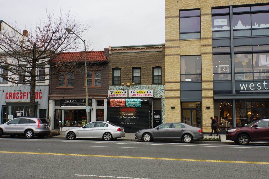
Gentrification itself isn’t necessarily the problem, since in theory it could help revitalize a struggling inner city area, bringing in more development, more jobs, and improved housing. The displacement of low-income workers, however, is the critical issue, with these workers generally unable to afford the revitalized or newly constructed housing in gentrified areas and little attention paid to providing affordable housing options. Furthermore, coupled with suburbanization and urban decentralization, affordable housing may only now be located in the distant suburbs, far from the well-connected central city’s transit systems. Paradoxically then, those who are in most need of mass transit options are then pushed out to the areas that are least served by them.
As cities continue to grow, change, and evolve, they will continue to face challenges. At the same time, they will likely continue to be centers of innovation, development, and interaction, just as they began. In many places, our world is no longer divided into strictly “urban” and “rural” areas, and cities extend far beyond their official boundaries. Rather, we might consider cities as part of a larger, more fluid area of urban, suburban, and rural developments. Regional planning efforts will thus be critical in helping to develop sustainable cities that are well-connected with their outlying areas and provide affordable housing opportunities for all their residents.
the shifting of population from rural areas to urban areas
the center of a city and the focal point for the exchange of goods and services
the observation that the nth largest city in a country has 1/n the population of the largest country
a city that is the largest city in a country, is more than twice as populous as the next largest city, and is emblematic of the national culture
a city with a population of over 10 million people
an area that includes a city and its surrounding, developed region
a United States Census designation, defined as an urban area, the county within which it is located, and surrounding counties where a high percentage of the residents commute to the central county for work
a group of two or more overlapping metropolitan areas
the unrestricted growth of an urban area over a large tract of land, also known as sprawl or suburban sprawl
the process of businesses, workers, and consumers, moving away from the central business district
a model of the internal structure of a city where zones of businesses and residences are arranged in concentric rings outward from the CBD
the idea that the price and demand for real estate decreases as the distance from the city center increases
a model of city structure where zones of development extend out from the CBD in wedges
a model of internal city structure where clusters of development occur in nodes or separate nuclei outside of the CBD
an urban area with businesses, shopping, and entertainment outside of the traditional CBD
an area of lower density housing outside the central city and surrounding suburbs where people live and commute to the central city for work
a policy aimed at denying services to residents of particular ethnic or racial communities
the process by which the character of a neighborhood changes as more affluent residents and businesses move in
