La función de los mapas
Los mapas son importantes por varias razones. Los mapas presentan información visual sobre las diferentes naciones y sus culturas, el medioambiente y el movimiento de personas y productos por el mundo. Hoy en día, usamos los mapas en forma de GPS para viajar distancias largas y cortas. En Google Maps, es posible ver cualquier parte del mundo en tu computadora.
entender la materia
Los mapas
According to the reading above, what are three things we can learn from maps?
Los cognados
There are many English cognates (words that look similar to the English word and have the same meaning).
- Write five cognates from the reading. What spelling differences do you notice?
- Take a guess. What are these words in English?
-
- por varias razones
- las distancias
Personalizar la lección: Talking about distances
El mapa que está arriba presenta el camino desde Albright College al Ayuntamiento de Filadelfia. Albright está a una hora veintidós minutos del Ayuntamiento de Filadelfia y está a sesenta y ocho millas.
Using Google Maps, look up the distance between your house and Albright College in millas, horas, or minutos.
-
- ¿A cuánto está tu casa de Albright College?
- Mi casa …
- Now ask three classmates the same question in Spanish. Write down each of their answers.
- ¿A cuánto está tu casa de Albright College?
*In many Spanish-speaking countries, the numbers zero to twenty and all numbers that end in zero are spelled in most kinds of written texts. But as in English, style guides vary.
Your teacher may ask you to learn how to spell other numbers, too. For practice visit Spelling Numbers.
El viaje en coche
You want to take a road trip to major cities in North America but first need to figure out how far your destination city is from your starting point. Spell out the hours and minutes between the cities using what you learned in the previous activity.
- Chicago está a … horas … minutos de Nueva York.
- Los Ángeles está a … horas … minutos de Las Vegas.
- San Augustín, Florida está a … horas … minutos de Miami.
- Corpus Christi está a … horas … minutos de México D.F., México.
- Detroit está a … horas … minutos de Toronto, Canadá.
Nuestro mundo

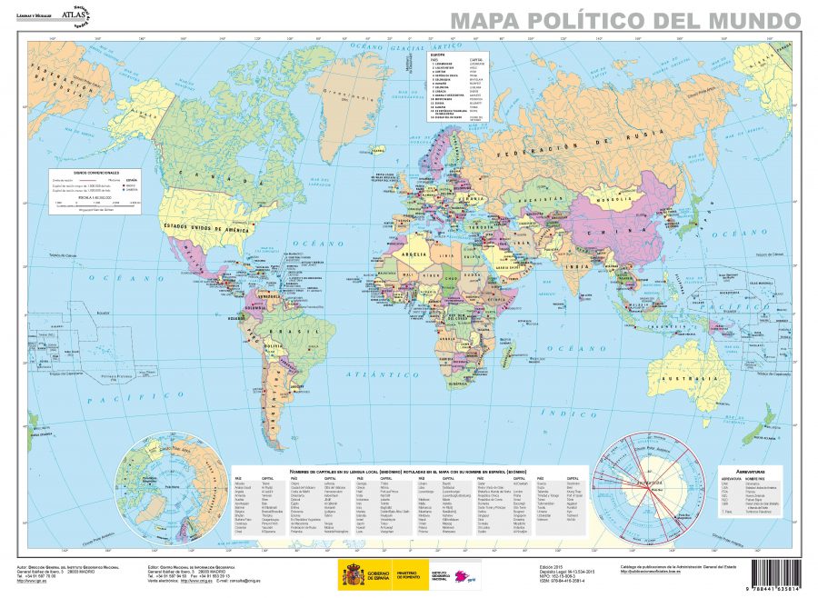
¿Cuánto sabes del mapa del mundo?
¿Dónde está?
Use the verb estar and the vocabulary to answer the questions according to the map you see above.
Modelos:
Estudiante 1: ¿Dónde está China en el mapa?
Estudiante 2: China está a la derecha en el mapa.
- ¿Dónde está Europa en el mapa?
- ¿Dónde está Estados Unidos en el mapa?
- ¿Dónde está Argentina en el mapa?
- ¿Dónde está Australia en el mapa?
Continentes
Busca los países y explica en cuál continente están.
Los continentes: África • América del Norte • América del Sur • Antártida • Asia • Australia • Europa
Modelos:
Estudiante 1: ¿En cuál continente está China?
Estudiante 2: China está en Asia.
- ¿En cuál continente está México?
- ¿En cuál continente está Colombia?
- ¿En cuál continente está Guinea Ecuatorial?
- ¿En cuál continente están Filipinas?
- ¿En cuál continente está España?
Los mapas son incorrectos
Los mapas tienen varias funciones, pero no son totalmente correctos. Mira el vídeo Why all world maps are wrong y descubre por qué.
Contesta las preguntas en grupos pequeños y escribe las respuestas.
- According to the video, why are all two-dimensional maps wrong?
- What does the map we use most often tell us about European hegemony?
- How do you think maps allow us to understand more about a particular culture? Give an example.
El mundo es redondo

The Cahill-Keyes map is a different projection. What do you think this map reflects?
¿Es más grande o más pequeño?
Decide si las oraciones son verdaderas o falsas. Corrige las oraciones falsas.
- Francia es más grande que Colombia.
- Ghana es más pequeña que Irlanda.
- Texas es más grande que España.
- Argentina es menos grande que Pensilvania.
Check your answers by using the interactive website The True Size of.
After completing this theme, I can …
- mention three ways maps are useful, in Spanish.
- pick out English cognates from readings in Spanish.
- talk about the distance between point A and point B by using está a.
- describe where countries are located by using estar with cardinal directions (norte, sur … ) and a few location prepositions (a la izquierda, centro … ).
- explain how the standard world map we most use is wrong.

