The University of California, Berkeley is – according to the author’s knowledge – the only major university in the world, whose campus is intersected by a dangerously active earthquake fault. The Hayward Fault, a branch of the San Andreas Fault system in the San Francisco Area of northern California, cuts through the eastern part of campus, most prominently through the playing field of the University’s football arena, the California Memorial Stadium. Ranked by the latest probabilistic hazard analysis (UCERF-3) as the most dangerous earthquake fault in the greater San Francisco region, the Hayward Fault is thought to be able to generate magnitude 7.5 earthquakes, capable of causing significant damage. At the same time, some sections of the Hayward Fault are in constant motion. Across campus the fault creeps along aseismically by a few millimeters a year.
The fact that UC Berkeley is located on the Hayward Fault was not intentional. At the time the first students and faculty occupied the campus, in 1873, the science of seismology was in its infancy. Earth scientists were still oblivious to the causes of earthquakes, phrases like earthquake fault had not even been invented and the concept of plate tectonics would be almost a century away. Nevertheless, since the university’s founding Berkeley faculty has played a major role in advancing the science of earthquakes and of seismic monitoring. In fact the first seismometer network in the western hemisphere was set up by Berkeley scientists in 1887. After adapting many times to advances in technology, it is still in operation today in northern California and southern Oregon as the Berkeley Digital Seismic Network. In addition, the Berkeley Seismological Laboratory (BSL) operates several local seismic networks.
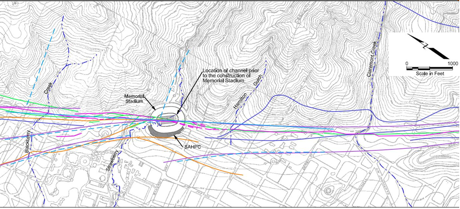
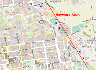
Despite the fact that the Hayward Fault is one of the best studied earthquake faults in the world, it remains rather elusive. We are not talking about the lack of reliable earthquake prediction but instead about uncertainties in the exact location of the fault. Figure 1 shows a topographic map of the foothill area of East Berkeley with UC Berkeley’s stadium prominently displayed. While many details in this map are not relevant for our tour, the important information is contained in the colored lines crossing the map. Each line represents the estimate made by one researcher or group of scholars as to the location of the fault. In some areas, these locations vary by more than 1000 ft. The reader may keep these uncertainties in mind, when looking at maps of the locations of our tour stops, as in figures 2 and 5.5. There we show the fault as a single straight line for reasons of simplicity.
In the following, we highlight some of the major features of the Hayward Fault on campus. We will visit sites where the continuous aseismic creep along the fault is tearing at buildings, structures and roads, we will see examples of how the University mitigates some of the risk posed by the seismic hazard and we will look at methods to monitor the seismic activity of the fault.
This pamphlet is designed as a guide for a walking tour to the points of interest as they are shown on the maps in figures 2 and 5.5. The numbering of these points on the maps is consistent with their nomenclature in the text.
Paragraphs set in italic font and underlain in light grey explain how to get from one point of interest to the next.
This tour is designed as a walking tour. Taken in its entirety the tour will take about 2.5 hours, depending, of course, how much time one spends at each stop. The tour can also be broken up in sections to be taken at different times. During our walk, we will mostly stay on UC Berkeley’s property or on public roads. However at point 6 we will be looking at private property. Please respect the privacy of the owner and his neighbors and avoid loud noise. A word of caution: As the Hayward Fault runs along the foot of the Berkeley Hills, we will encounter several steep climbs and stairways during our walk. Be prepared by wearing sensible shoes and by carrying some drinking water and perhaps a snack. You are welcome to take as many pictures or videos as you want.
The tour starts on the north side of the Mining Circle at the base of the impressive stairs leading to the Hearst Memorial Mining Building, point 1 in figure 2. Walk into the building and stop in the grand lobby, the Memorial Gallery.
