10 Coupled Infrastructure Systems for Water
Key Concepts
In this chapter we will:
- Demonstrate the CIS framework applied to diverse water systems
- Learn that water systems only function properly if the various types of infrastructure are maintained.
10.1 Introduction
In this chapter, we discuss a number of case studies of irrigation, drainage, and sewage systems from a coupled infrastructure perspective. These cases provide a rich set of examples of how to apply the CIS framework. In all these cases humans created physical infrastructure to aggregate water in the landscape, store it, and transport it to canals and pipes, and dispose of the water at a designated location. This allows societies to regulate water availability and reduce the chances of floods and droughts.
The creation, maintenance, and use of this hard infrastructure requires collective action. The earliest records of irrigation that have been found date to about 8000 years ago in the Middle East (contemporary Iraq and Iran) and cases of independent development of irrigation systems are found all over the rest of the world. There is a wide variety of ways in which infrastructure is built ranging from mud-based canals and simple wooden diversion structures, to concrete canals and computer operated diversion gates.
Karl Wittfogel (1957) argued that the need to solve the many problems associated with complex irrigation systems is one of the sources of complex societies. In his view, large bureaucratic systems are needed to coordinate labor and supplies required to build, operate, and maintain large irrigation systems. These bureaucratic systems, he argues, were then later extended to the rest of society. Although this is an interesting and plausible argument, it rests on a basic assumption: top-down intervention is needed for the operation of large, complex irrigation systems. From many studies of irrigation systems in the last few decades, we see a different story emerging that suggests that this is not necessarily the case. We will discuss various cases in this chapter where decentralized bottom up governance leads to high performance of hydrological systems.
The governance of water requires the maintenance of various types of infrastructure. Key infrastructure types include natural infrastructure such as watersheds and the human-made infrastructure of dams, canals, pumps, and treatment plants. Water governance is arguably one of the most important issues we face today. We use water every day to drink, to cook, to shower, to wash, to flush, to clean, to irrigate, to swim in, etc. The importance of water makes it a central object of many social dilemmas: too little clean water, too much polluted water, unequal distributions of water, and variability in water availability.
One drop of water can be used multiple times for different uses, so technically water itself is not subtractable in the sense that the same drop of water used by a city resident to wash their dishes can be used later to water a golf course. This is exactly the same as the situation with a book in a physical library. One person can read a book now, then someone else can read it later. The key limit is that the resource cannot be used for two different purposes at the same time. So, if clean freshwater is being used for washing, flushing, drinking, etc., that same quality of water is not available for other activities at that time. Even though we can use creative coordination mechanisms and technology to recycle shower water to flush toilets, nevertheless, usable water is frequently discarded as wastewater to the sewer system or the natural environment. At that point, such water needs to be recollected and treated for reuse. Hence inefficient use of water by individuals leads to a shortage of clean fresh water for the group. Thus, water use is a social dilemma, or as social dilemmas associated with common-pool resources are sometimes called a “commons dilemma.”
10.2 Phoenix, Arizona, USA
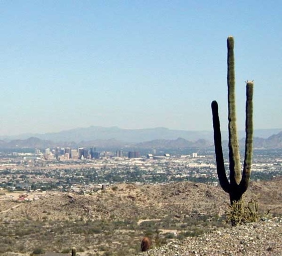
The city of Phoenix was founded in 1861. Since then, the population in the Phoenix metropolitan area has grown to about 4.8 million people (2020). The city has a subtropical desert climate with temperatures up to 118∘F (48∘C) in the summer, and average annual precipitation of 8.3 inches (210 mm). As places to live go, Phoenix is a harsh climate to be sure (Figure 10.1). This raises the question of why do so many people live in the desert? Where do they get their water from?
Note that both authors have lived in the Phoenix metropolitan area since the early 2000s.
When the Mexican-American war ended in 1848, Americans started to explore the west in search of riches. One such explorer, Jack Swilling, while on an outing near the White Tank Mountains in 1857, noted an abandoned river valley. This valley, where modern-day Phoenix is located, in fact, has excellent terrain, fertile soils, and an excellent climate for farming. All that was required was water.
Swilling was not the first to recognize the farming potential of the valley. The Hohokam people lived in the valley for more than 1000 years and created 135 miles (217 kilometers) of irrigation canals. The Hohokam were very successful farmers and engaged in an extensive trade network that covered a significant portion of what is now the state of Arizona. There are many archaeological features that attest to the scale of Hohokam irrigation society. After about 1070 C.E. Hohokam society began to change and by 1450, the Hohokam abandoned the valley. The reasons for the abandonment are not known, but might relate to a period of major droughts and severe floods, destroying important physical infrastructure. It is the remains of Hohokam irrigation systems that sparked Swilling’s imagination for what the potential of the valley might be. Swilling built a series of canals following the Hohokam system, thus founding Phoenix. The name Phoenix was chosen to reflect the fact that it is a city born from the ruins of a former civilization. Even today, canals providing Phoenix with water follow the ancient canal systems of the Hohokam.
Initially, Phoenix was a productive agricultural area for cotton and citrus with year-round sun and plentiful irrigation water from the Salt and Gila Rivers. In 1911, the Roosevelt dam was created east of the valley, which provided a more predictable source of water and, with it, the opportunity to grow to a population of 150,000 people. By damming the Salt River, water could be accumulated in the mountains near Phoenix and distributed via irrigation canals. As a result, the Salt River bed that runs through Phoenix is dry most of the time.
In 1922, the seven U.S. states that are part of the basin of the Colorado River created an agreement, called the Colorado River Compact. This agreement defines the allocation of water rights among the states of Colorado, New Mexico, Utah, Wyoming, Nevada, Arizona, and California. Based on historical rainfall patterns, the flow of the Colorado river was equally divided between the upper-division states (Colorado, New Mexico, Utah, and Wyoming), and the lower division states (Nevada, Arizona, and California).
Defining the rights to Colorado River water created opportunities for irrigation, and led to projects like the creation of the Hoover dam to harvest Colorado River water. Arizona was dissatisfied with the agreement and did not ratify it until 1944. Negotiations dragged on for almost 20 more years until specific disagreements with California were settled in the Supreme Court in 1963. The verdict specifies that California can use 50% of the river flow up to a maximum of 5.4 cubic kilometers annually, Nevada 0.4 cubic kilometers and Arizona the remainder of the lower Colorado river flow.
After solving the allocation problem, the way was cleared for the construction of the largest aqueduct system within the U.S., the Central Arizona Project. Three hundred and thirty-six miles of canals bring the water from the Colorado River to the urban areas in the central and southern regions of Arizona (Figure 10.2). The project started in 1973 and took 20 years to complete. Since the 1950s the population in the Phoenix metropolitan area has rapidly increased. This was made possible by the availability of affordable air conditioning. With the rapid growth of the city, agricultural land was transferred into urban use. Although urban use includes golf courses, swimming pools, and the domestic use of water, water use per ha in an urban setting is still considerably less than for agricultural land, which uses a lot of water for irrigation.

Nevertheless, since the 1990s there has been a drought that has led to lower water flows in the Colorado River. As water demand continues to grow, the city will either be forced to increase the use of groundwater or to direct ever more water away from agriculture to meet the demand. In order to evaluate the water use challenges for the future of Arizona, Arizona State University has developed a simulation model that enables observers to explore the consequences of droughts, population increase, and water policies. You can explore different scenarios of water use projections here.
In the beginning of 2022, a Tier 1 Water Shortage declaration was s put in effect since the water levels in lake Mead dropped below 1075 feet, and in 2023 a Tier 2a Water Shortage declaration was put in effect since the water level in lake Mead is expected to drop below 1050 feet. Crossing those predefined levels triggers water allocation reductions that amount to 21% of the allotted water to Arizona from the Colorado river, which has to be absorbed by the agricultural community, as specified by regulations from the 1960s. As one can imagine, the current water crisis leads to major disputes how water is used by some land owners, growing water intensive alfalfa to execute their individual water rights, and major investments, more than 1 billion dollars, by the state government to bring additional water sources to the state. Interesting is the focus on increasing water supply rather than on reducing water demand. It is an open question what a water secure future for Arizona looks like with the continuing change in water supplies driven by climate change.
The story of the development of Phoenix is one of how water scarcity was overcome with shared infrastructure. There is no way that a small group of individuals could build the Roosevelt Dam. Previous efforts by smaller groups to build canal systems often failed. Getting water to the arid west required a monumental effort. In this case, a central government was essential to provide public infrastructure due to the scale of the problem. This is not always the case. Sometimes smaller groups can solve such large-scale problems, as we shall soon see.
10.3 The Netherlands
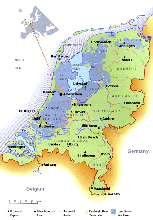
The Netherlands is a small country in Western Europe. The average income per person is one of the highest in the world. However, 25% of the Netherlands is actually below sea level (Figure 10.3). Furthermore, some of the biggest rivers in Europe cross the Netherlands on the way to their final destination in the North Sea.
In contrast to Phoenix, the Netherlands is a place with an abundance of water. Over time the Dutch have had to solve various social dilemmas to keep their feet dry.
Before 800 C.E., the inhabitants of the precursor of the Netherlands used non-structural measures to keep their feet dry. Such measures like man-made hills or abandoning areas in times of danger were the result of decisions made by individual households. Due to increased population pressure, developments in technological know-how, and finance, there was a rapid increase in the development of structural water control measures after 800 C.E. Such measures included dikes and sluices. Construction and maintenance of these structures required cooperation within communities.
Farmers whose lands directly bordered the dikes agreed to commit themselves to the necessary construction work and maintenance activities. Coincident with the construction of dikes, drainage activities began to be developed as well. To make the lowland area inhabitable, it was necessary to get rid of the extra water. Small dams and sluices were built and maintained, based on similar agreements as for the flood protection systems between direct beneficiaries. A noticeable difference with regard to input for dike maintenance and small dams and sluices was the fact that in the case of the latter, all beneficiaries had to pay for the benefits received. These dikes, dams, and sluices are all quintessential examples of public infrastructure.
Originally, the local communities in the countryside were in charge of all general collective interests and took responsibility for water management as well. Around 1100 C.E., however, a new adaptation occurred as water management tasks gradually began to become separated from general public tasks. The reason is likely due to the increase in the number and severity of flooding events as well as a growing interdependence and complexity of the hydraulic works that began to stretch beyond the local scale.
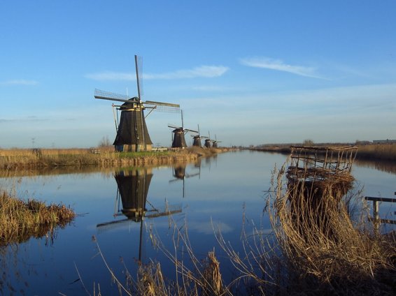
Starting at the end of the 11th century and the beginning of the 12th century, the first public bodies charged with governing local and regional water management appeared on the scene and the phenomenon of the water boards was born. The purpose of the water boards was to construct and maintain the necessary hydraulic structures, providing safety through dikes and dry feet through drainage (Figure 10.4). Their establishment was recognized by the higher, regional authorities who still held themselves responsible for good water management but who resigned from their administrative duties.
Each of the water boards differed in their design and implementation of physical structures as well as rules. They were also confronted with different problems. They were not always successful in preventing floods or draining areas effectively. During the period known as the “Republic of the United Provinces of the Netherlands” from 1581 to 1795, there were severe floods and extensive peat-digging (for fuel), which caused unintended artificial lakes and diverse management problems. Still, the water boards survived this period. One of the main reasons for the long-term adaptation and survival of the water boards is the institutional arrangements upon which they are based. The design of rules was based on the shared norms and values of the population. Although the water boards were not always successful in maintaining safety and dry feet, they were maintained anyway because changing them would be costly. The benefits associated with switching to new and unfamiliar institutional arrangements in an effort to improve performance may have been outweighed by the costs of operating these new institutions. Thus, the water boards maintained the familiar institutional arrangements, which they knew how to operate and that they could adapt. Perhaps the roots of the shared norms in contemporary Dutch society goes back to those people who found ways to make the land liveable by developing institutions based on reciprocity.
Since the Napoleanic occupation of the Netherlands in the early 1800s, there has been an increased centralization of water governance over time. Although water boards are still independent organizations, a ministry of water management was created in order to coordinate water management over the entire country. In 1953, a major flood in the south of the Netherlands killed 1800 people. This event led to an increased effort to protect the increasingly urbanized Netherlands from potential floods. As a result, there has been a huge amount of investment in infrastructure made to reduce the risks of flooding over the past 60 years.
Interestingly, major challenges for the future of the Netherlands do not come from the sea. The canalization of the river Rhine has made the river more suitable for the transport of goods to Germany via ships, but it has also reduced the natural buffering capacity of the river. Removal of swamps that naturally would be areas to buffer excess water, now leads to rapid transport of water down the river during rain events. As a consequence, floodings now happen more frequently in the river delta. Upstream countries need to increase their buffer areas to reduce the flooding risks in downstream countries. This situation raises an important point: there are often inherent trade-offs when choosing among performance, robustness (the capacity to cope with change) and robustness to different types of shocks. So the Netherlands has become fairly robust to weather shocks from the sea but, in so doing (occupying more and more low-lying land) it has become more vulnerable to weather shocks from continental Europe (flooding of the Rhine due to rain). Can you run the same mental experiment with the situation in Arizona?
The history of the water boards shows a continuous tinkering with rules at different levels of organization and spatial scales. Disturbances like floods and the unintended consequences of peat digging have triggered the development of new rules and structures. The Dutch water boards illustrate how local-level governance structures may evolve into a resilient collaboration of multi-level governance structures when national institutions recognize the importance of smaller governance units and work with them rather than destroying them.
10.4 Bali, Indonesia
As we have seen, irrigation requires coordination and cooperation. One has to build infrastructure in order to move water around. This infrastructure needs to be maintained in order to function properly. By maintenance we mean cleaning of the canals and repairing damage to levies and diversion structures. Once the infrastructure is in place, water needs to be shared. In most cases, farmers who have their plots of land near the source of the water have preferential access to the water. In order for downstream farmers to get the water they need, the upstream farmers need to restrict their use of water. But given our earlier discussion of social dilemmas, why would they do this? An iconic example can be found on the island Bali, Indonesia.
Before we discuss this case, we would like to indicate that an increasing share of food production is dependent on irrigation where water is distributed from sources (rivers, groundwater, lakes, etc), to individual plots of land. About 70% of the global freshwater supply is used to irrigate small plots (over 90% of plots worldwide are less than 2 hectares or about 4 football fields). In order to get available water to the right location at the right time, a coupled infrastructure system is required which may vary in scale and complexity depending on the biophysical and cultural context.
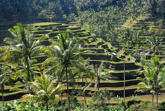
Bali is one of the islands of Indonesia that has had a complex and very productive irrigation society for about 1000 years. Hundreds of irrigation communities called subaks are connected via waterways that begin at a lake near the top of an old volcano (Figure 10.5). Canals connect this water to subaks downstream. This complex irrigation system has been studied in detail by anthropologist Stephen Lansing and has been made famous in a book titled Priests and Programmers.
The irrigators have to solve a complex coordination problem involving water distribution and pest control (they didn’t have pesticides 1000 years ago). On the one hand, control of pests is most effective when all rice fields in a particular subregion are on the same schedule for planting rice. This is due to the fact that the pests (insects called planthoppers) are limited in their ability to move (or disperse) on the landscape. If large enough areas are kept fallow (areas without plants) between planted areas, the planthoppers can’t cross them because there isn’t any food to keep them alive while they cross (i.e., the fallow areas are “food deserts”). This keeps pest outbreaks localized if they occur at all. On the other hand, the terraces (see Figure 10.5) are hydrologically interdependent, with long and fragile systems of weirs, tunnels, canals, and aqueducts used to control where water goes, making it challenging to get the water to all the fields while maintaining large enough fallow areas between planted areas, all in a limited growing season.
To balance the need for coordinated fallow periods and water use, a complex calendar system has been developed that determines what actions should be carried out on each specific date. These actions are related to the spiritual practice of making offerings to “water temples” at several levels: small temples at the rice terrace level, the temple at the village level, and the temple at the regional level, associated with the Pura Ulun Swi, “the Head of the Rice Terraces” (this is the temple of the high priest Jero Gde, the human representative of the Goddess of the Temple of the Crater Lake, the main source of water for irrigation). These offerings of water and other items were collected as a counter performance for the use of water that belonged to the gods. These ritual practices trigger the calendar actions (i.e., people make offerings at particular times after which they can plant, etc.).
Balinese society consisted of many kingdoms before the conquest of territory of Bali around 1900 by the Dutch. The Dutch saw these offerings made to the various temples in a different light, namely as a royal irrigation tax. The fact that during the nineteenth century there were quite a number of kingdoms in Bali was a sign that the institution of kingship had weakened over time from one powerful kingdom to a number of smaller kingdoms. Therefore, the Dutch wanted to restore centralized government; in particular they wanted to use a revived royal irrigation tax to improve the irrigation system. The Dutch administrative reorganization failed, partly due to lack of funding, but also because historical analysis conducted during the 1930s demonstrated that there was no evidence that Bali had ever had a centralized government. Although Indonesia became independent from the Netherlands after World War II, many aspects of the colonial bureaucratic system were adopted by the new independent government.
During the late 1960s, the Indonesian government made self-sufficiency in rice production a major goal for national development. In the same period the Green Revolution began in Asia. The Green Revolution involved the spread of new rice-growing technologies that promised a dramatic increase in rice production. Bali was one of the first targets of the Green Revolution. In contrast to the earlier Dutch attempts to modernize rice production in Bali, this time the engineers were well funded.
The function and power of the water temples were invisible to the planners involved in promoting the Green Revolution. They regarded agriculture as a purely technical process. Farmers were forced to switch to the miracle rice varieties which would produce three harvests a year instead of the two that could be achieved with traditional varieties. Farmers were motivated by governmental programs that subsidized the use of fertilizers and pesticides. The farmers continued performing their rituals, but now they no longer coincided with the timing of rice farming activities. Soon after the introduction of the miracle rice, a plague of planthoppers caused a huge amount of damage to the rice crops. A new rice variety was introduced, but it was followed by another pest plague. Furthermore, water shortages began to occur because there was nothing to replace the rituals (which were now out of step with plantings) which had been the basis for the efficient allocation of water.
During the 1980s, an increasing number of farmers wanted to switch back to their old ritual-based system, but the engineers interpreted this as religious conservatism and resistance to change. Steve Lansing quotes a frustrated American irrigation engineer “These people don’t need a high priest, they need a hydrologist!” (Lansing 1991 p. 115). It was Lansing who unraveled the function of the water temples, and was able to convince the financiers of the Green Revolution project on Bali that irrigation and rice cultivation was best coordinated at the level of the water temples. Lansing built a computer model of the artificial ecosystem, and showed that for different levels of coordination, from farmer level up to central control, the temple level was where decisions could be made to maximize the production of rice.
As this story suggests, the complex irrigation system on Bali and the role of the temples in operating it has evolved over a long history of local adaptations at different levels of organization and different spatial scales. The water temples played a significant role in the coordination of the use of water, but also in providing technical advice and mediating water use conflicts between different subaks. By making offerings to different temples, the farmers were made aware of the interconnections between the water flows at different scales. Due to Lansing’s insight and analysis, some of these systems have evolved still further and avoided the fate of many self-organized systems of this kind when experts declared them defunct and constructed new infrastructure without paying much attention to local property rights, ecology, culture, and traditions.
10.5 Sanitation
A huge portion of potable water household use is designated for sanitation. It is remarkable that we use a valuable resource, water, to dispose of another valuable resource, human waste. Human waste is a valuable resource, largely as a natural fertilizer. Hunter-gatherers had a natural disgust for human waste, did not like the smell, did their necessities outside the campsite, covered it, and moved the camp around regularly to avoid any problems human waste could cause. Although they were unaware of disease transmission related to human waste, this behavior avoided disease spread.
When humans started aggregating in higher densities, a more elaborate system of recycling night soil was established in various locations. In Edo, the precursor of Tokyo, an elaborate poop economy was created to harvest the productive night soil to fertilize the nearby farmland. When a person was visiting another household, the person likely ran back home if they felt an urge for a number 2. Leaving a dropping at another household was considered a gift. The benefits of recycling night soil worked well in Edo since Japanese had (and have) a strong culture of hygiene, they cooked their vegetables, had a sophisticated composting system, and heated their water to drink tea. This avoided – without their knowledge – the problem of spreading germs.
In Europe, urbanization has increased the distance between farmers and producers of human waste. This has reduced the economic viability of the reuse of human waste as fertilizers. Europeans started using water to dispose of human waste, leading for example to the Great Stink in London in 1858 due to a large volume of untreated human waste and warm weather. The discovery of the germ theory disease and the availability of cheap germ-free fertilizer alternatives (first guano, then artificial fertilizers) made the reuse of human waste less desirable.
If we focus on the current situation, about 25% of the human population has no proper sanitation facilities. This is a major causal factor in the spread of diseases. Providing these populations with a Western approach to human waste disposal is neither desirable nor sustainable. Human waste has a lot of potential to be reused for fertilizers and energy creation. The water intensive Western approach to human waste disposal is no longer option with the concurrent decrease in the availability of freshwater around the world and increase in human populations (and their waste). In 2011, the Gates foundation started an initiative to reinvent the toilet. There are many new approaches being explored to reduce water use and collect human waste at scale in a way that provides good jobs (instead of suppressing lower casts to do dangerous and “shitty” work). See, for example, the various examples from container-based sanitation that lead to reuse for fertilization and energy production.
Although sanitation might not be a typical dinner conversation, managing where the dinner ends up is a key issue for humanity that needs to become less wasteful. Changing this will require not only technical innovation but also changes in norms and perceptions of what is acceptable regarding where the dinner ends up. The changes in the coupled infrastructure systems relating to the management of human waste, as reported in the popular book by Zeldovich (2021), demonstrate the dynamics of economic, social and engineering processes that lead to continuous change of the infrastructure.
10.6 Critical reflections
Hydrological systems such as drainage and irrigation systems, can be found around the world for millennia, and are good examples of coupled infrastructure systems. Those systems demonstrate how the biophysical and cultural context impact the kind of engineering and institutional solutions that are possible.
10.7 Make yourself think
- What are examples of hydrological systems near you?
- What water distribution problem does the hard infrastructure aim to solve?
- How is this hydrological system be maintained?
- How much water does your household use, and where does the water come from?
10.8 References
Lansing, J.S. (1991) Priests and Programmers: Technologies of Power in the Engineered Landscape of Bali, Princeton University Press.
Wittfogel, K. (1957). Oriental despotism; a comparative study of total power. New York: Random House
Zeldovich, L. (2021) The Other Dark Matter: The Science and Business of Turning Waste into Wealth and Health, Chicago University Press.
