1
Teacher Introduction:
Where did the state of Colorado come from? Its rectangular borders do not align with any significant landscape feature. Mountains run north and south through the middle of the state and continue in both directions into Wyoming and New Mexico. Four major rivers all begin in Colorado (South Platte, Arkansas, Colorado, and Rio Grande) but flow outward in different directions without any regard for the state’s straight line borders.
What kinds of people have lived in Colorado? Historically, the state’s mountains, plains, and river valleys have all been home to diverse Native Americans, Hispanic peoples, Euro-American migrants, African Americans, and Asian Americans. They occupied diverse regions of Colorado and also moved in and out of state territory in both voluntary and forced migrations.
One helpful introduction to these historical questions about Colorado’s landscape and demographic diversity is through maps. This chapter is designed to expose students to a range of map types and help them explore maps for the stories they can tell. These maps are not meant to provide the final and definite answers to these important historical questions. Rather, the students will hopefully finish this chapter with new curiosity and questions about Colorado geography and history. They will begin to see how maps can help recreate the past when students compare them and link them to other kinds of evidence.
The historical maps in this lesson also give students a chance to study different kinds of evidence. There are of course more modern and up-to-date versions of many of these old maps. We have included examples and links to these as well. But these historical artifacts offer imperfect fragments that students can puzzle over and investigate. In the process of pondering, students in fact are doing the work of history—learning to tell stories about the past based on incomplete evidence and information.
By studying and comparing these different maps, students will begin to learn important aspects of Colorado history and geography. Ideally, they would encounter these maps again in connection with later lessons. The subsequent chapters will refer to these maps in order to deepen student understanding and provide new connections.
***
Sources For Students:
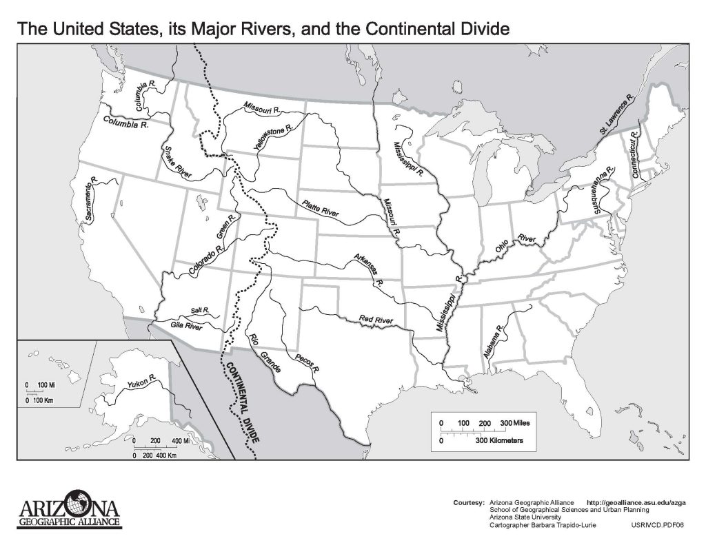
Map 1. Current Map of the United States with major rivers.
Questions and Activities:
- On your copy of this outline map of the United States, find Colorado and label it. What states are neighbors of Colorado? Label those too.
- If you were traveling from the spot where the Missouri River meets the Mississippi River to the Rocky Mountains, what states would you move through? Label those.
- What rivers begin in Colorado? Your teacher can help you add the South Platte River and connect it to the Platte in Nebraska.
- The Continental Divide runs through a major mountain range. What do we call those mountains? What do you think Continental Divide means?
- Label your hometown on this map.
***
Map 2: Stamp from 1904
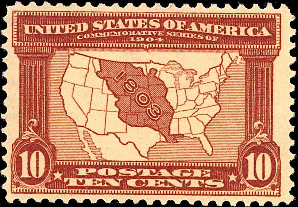
In 1904, the city of St. Louis hosted the World’s Fair. The US Post Office created this stamp to celebrate an event at the fair. The map on the stamp includes the year “1803” within a region marked in red.
[Source: Smithsonian Education. Available online: http://www.smithsonianeducation.org/migrations/stamps/stamp10.html]
Questions:
- Which states or parts of states are colored red on this map? (You could look back at outline Map 1).
- The label for that red region is “1803.” How can we find out what happened in 1803? (You may need to search on the internet here for information about the “Louisiana Purchase”).
- It appears that Colorado is both partly in the red region and partly out of the red region. Why might that be?
- The Post Office created this source in 1904. Can it still tell us something about 1803 even though that was more than 100 years earlier? How?
- None of the states inside the red region actually existed in 1803. Why do you think the Post Office included the outlines of those states on this map from 1904?
- Did Colorado join the United States in 1803? 1904? How could we find out?
***
Map 3: Mitchell Map of Texas, Oregon, and California, 1846
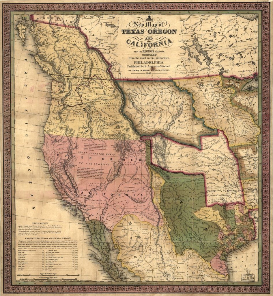
Augustus Mitchell created this map in 1846. Colorado was not yet a territory or a state. In fact, you will not see U.S. states on this map. The pink area actually belonged to Mexico in 1846. The area in green was claimed both by the state of Texas and Mexico. Disagreement over these two areas led to a war between the United States and Mexico from 1846 to 1848. Above the green area was “Indian Territory.” Native Americans were the main people living in that area.
Look for the area that will become Colorado where the pink, green, and tan colors meet.
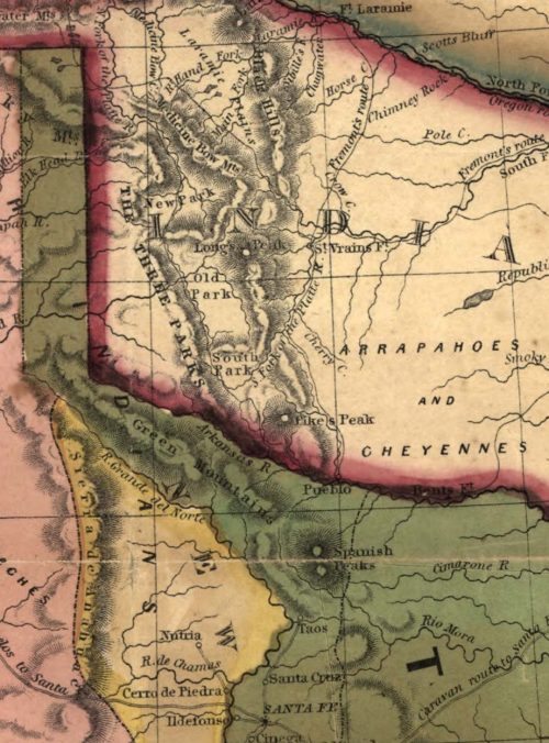
Here is a close-up of this same map, which shows the area that will later become Colorado. You can see some details listed such as: “Longs Peak,” “South Fork of the Platte R,” (river), and “Arkansas R.” (river).
[Source: Augustus Mitchell, “A New Map of Texas, Oregon, and California,” (1846); available from the Library of Congress online at: https://www.loc.gov/item/00561203/]
Questions:
- Look at the close-up map first. The US government created Colorado Territory in 1861. That was fifteen years after this map was drawn by August Mitchell. In 1846, what groups claimed the land that would become Colorado?
- The reddish line between the tan and green areas mostly marks the Arkansas River. The green area below was claimed by both Texas and Mexico. What two Indian tribes lived mostly above that river in 1846?
- What other places do you see labeled on the close-up map?
- Find Pueblo on the map. Why do think we can’t find cities like Denver on this 1846 map?
- Now take a look at the first Mitchell Map. What are the names of the different territories on this map? Can we tell what belongs to the United States and what doesn’t? How?
- What groups or countries claimed the area that would become Colorado?
***
Map 4: Hart map Territorial Expansion, 1891
In 1891 Albert Hart created this map that includes Denver but not the outline of Colorado. It has years printed within specific regions.
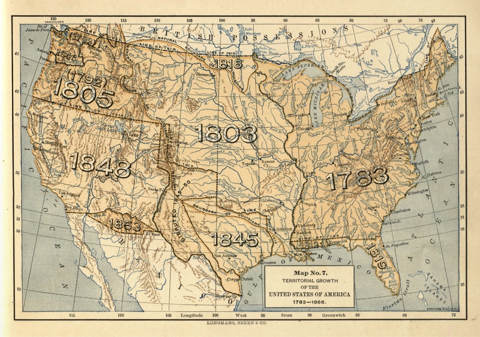
[Source: Albert Bushnell Hart, Epoch Maps Illustrating American History, https://babel.hathitrust.org/cgi/pt?id=hvd.hnx69l;view=1up;seq=41]
Questions:
- When did the land we now know as Colorado become part of the United States? (Hint: It could be more than one year.) When did your town become part of the United States?
- This map tells a similar story to Map 2. What are the differences?
- How could we find out what happened in those years on the map? Where could we look?
- When the United States gained control over the area marked “1848” were there already American states there? Or did the states come later? How could we find out?
- What could have happened to the different borders on the 1846 Mitchell Map (Map 2)?
- Do you think people were living in Colorado before 1803? What kinds of people?
***
Map 5: Route to the Colorado Gold Regions, 1864
This map is focused in specific ways people could get to Colorado. Yet, there are no state borders on this map and “Colorado” appears only in the map title. None of the borders from the previous maps appear on this map either.
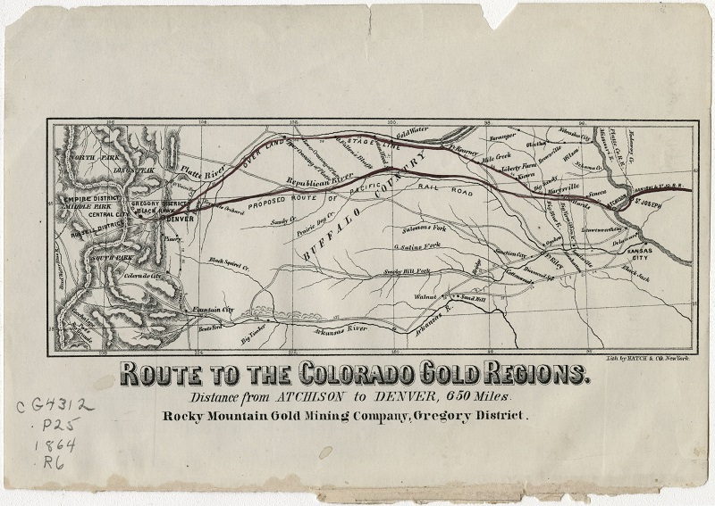
[Source: Denver Public Library. Call # CG4312 .P25 1864 .R6. Link to the Map Online: http://digital.denverlibrary.org/cdm/singleitem/collection/p16079coll39/id/807/rec/1
Questions:
- If we look at the map title, what’s the reason for creating this map?
- What details did the map maker include on the map?
- Why might the map maker include those details?
- Can you find anything you recognize on the map?
- Why do you think Colorado’s borders do not appear on this map?
- Why would so many rivers appear on this map? In 1864, how did people travel on the “routes” that are marked on the map? How could we find this out?
- What does “Proposed Route of the Pacific Rail Road” mean?
- Where did the mapmakers expect people to be coming from?
***
Map 6: Native Americans in Early Colorado
Before Euro-American fur trappers and miners migrated into the territory that became Colorado, there were many Native Americans already here. The map below was drawn by Donald Hughes. Hughes is a historian who drew this map in the 1970s, more than one hundred years after the Mitchell map in this chapter. He read different sources to find out where Native Peoples lived in the 1800s. Although he is not Native American, he did try to position tribes accurately on this map.
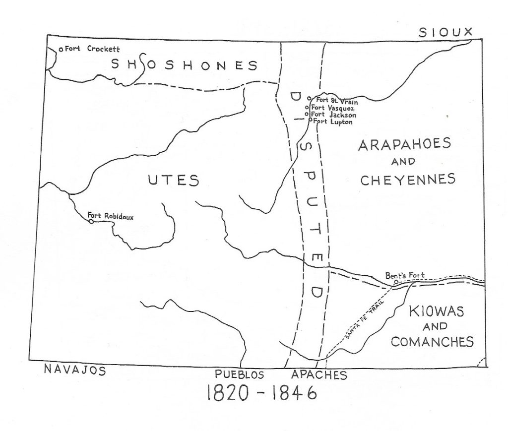
[Source: J. Donald Hughes, American Indians in Colorado (Denver: University of Denver, 1977) 75]
Questions:
- Between 1820 and 1846, what different Native American tribes lived on the lands that became Colorado?
- Look at the right half of the map. Why do you think that four tribes are linked together in groups of two?
- What tribes lived mainly outside the area that became Colorado in these years?
- Look at Map 5 alongside this one. When gold seekers came to Colorado, which Indian peoples did they likely encounter on the way?
- “Disputed” means that tribes competed with each other to control this area. That area runs along the Front Range or eastern side of the Rocky Mountains. How might those high mountains have affected the lives of these tribes?
***
Map 7: Indian Reservations Map, 1892
In 1892 an American government agency created this map of Indian Reservations in Colorado and other western states. Around the time that Colorado became a territory (in 1861), the US government was creating reservations where Plains Indians were supposed to live. These reservations meant much less space for Plains Indians to roam and hunt buffalo. The areas marked on the map for Native Americans are orange and gray colored.
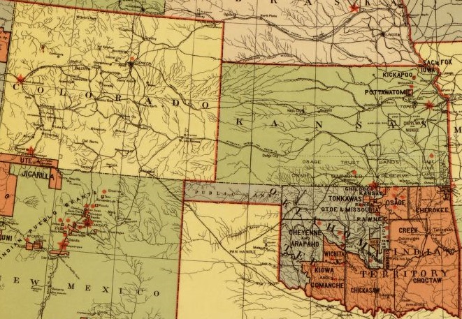
[Source: Library of Congress, Office of Indian Affairs, “Map Showing Indian Reservations with the Limits of the United States.” Link to map online: https://tile.loc.gov/image-services/iiif/service:gmd:gmd370:g3701:g3701g:ct002305/full/pct:6.25/0/default.jpg]
Questions:
- How is this map different from the previous map of Native Americans in Colorado between 1820 and 1846?
- The previous map listed several Native American tribes in the territory that became Colorado including the Ute, Cheyenne, Arapaho, Kiowa, Comanche. Where are those tribes on the map from 1892?
- Something obviously changed between the 1846 Mitchell map and this 1892 map and we’ll explore these changes in chapters ahead. Any ideas at this point about what might have happened to these Native American peoples?
- What would happen if you and your extended family had to stay in a smaller area than you were used to?
***
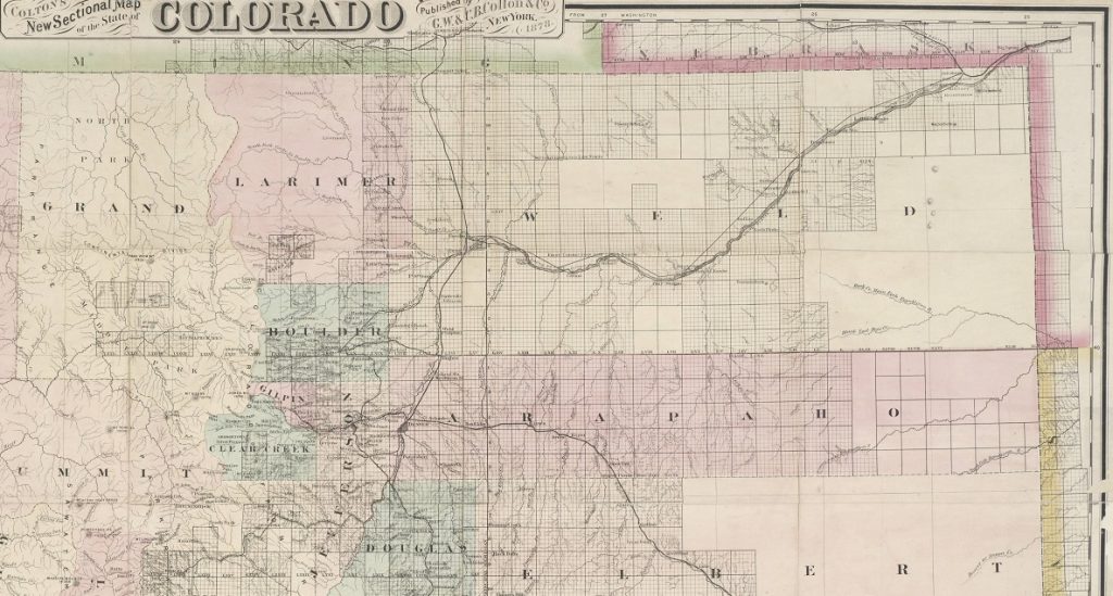
Map 8: 1878 Colton Map of Colorado
Two years after Colorado became a state, G. Woolworth Colton created this map. We have focused just on the Northwest corner of Colorado in this map. (It is easier to see detail on this map if you look online using the link below).
[Source Denver Public Library, Call # CG4310 1878.C6. Link to this map online:
http://digital.denverlibrary.org/cdm/singleitem/collection/p16079coll39/id/45/rec/1]
Questions:
-
- Why would Colton include different colors on this map? What might those colors represent?
- The Rocky Mountains would be on the left side of this map. What rivers can we see on this map?
- When this map was created, there were few towns in this part of Colorado. What counties besides “Weld” do you find?
- What other details did Colton include on this map?
- What might all of those black squares on the map mean?
- Why don’t Indian areas appear on this map?
How to Use These Sources:
OPTION 1: Colorado now and then.
For the lesson introduction, the teacher might begin announcing:
“Imagine that you are trying to learn about the geography and history of a state called Colorado but only have certain incomplete pieces of information. The historic maps in this lesson offer stories about a place called Colorado, but they do not tell stories all on their own. They need you to study the colors, details, shapes, and words to make sense of their meaning. The basic question for this lesson: What information can old maps tell us about Colorado history and geography?”
Then start as a class with Map 1, a basic outline map of Colorado today. All students should add details to this map with the teacher’s help. This exercise provides a basic context for the other maps that follow.
The series of maps that follow offer different perspectives on the land that became Colorado. Taken together, they offer an introduction to some key changes in Colorado and the American West between 1803 and 1890. This chapter is designed to raise questions and not just provide answers. Students can begin to ask—what peopled lived in the area before Colorado became a state? What motivated migrants to move to Colorado in the 1800s? How did Colorado emerge as a state in the United States? What happened to Native Americans who lived in this part of the American West after statehood? Subsequent chapters will guide students to explore these questions in more depth For now, it might be useful to generate questions for later reading.
Students could explore a single map (either 2, 3, 4, 5, or 6) in small groups. Each of these maps provides information about this region before statehood. Map 7 and 8 include details about Colorado soon after statehood. Other student groups could study those maps and answer questions. Then each group could present its map and answer the question—what does this tell us about the region that became Colorado?
OPTION 2: Summarizing Maps Graphic Organizer
The chart that follows could facilitate a comparison of all the maps in the chapter. After discussing individual maps in jigsaw groups, students could share findings with the class. Individuals will need to rely on other groups to tell the story of their maps. In this way, each group can bring together a piece of the whole puzzle.
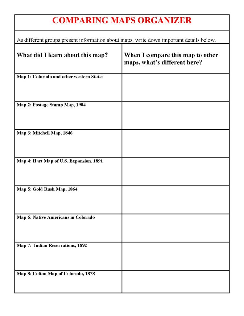
- OPTION 3: For a final assessment, students could use their notes on the Summarizing Maps chart to create their own individual historical maps of Colorado. They should start with a legal-sized piece of blank white paper and then draw a neat rectangular border for the state. They can they take information from the various primary source maps in this chapter to highlight the key details they learned. This could include:
- Physical Features: Rocky Mountains and Four Major Rivers and their watersheds.
- Historical Boundaries: between countries or between states.
- Cultural and Demographic Features: Native American peoples and later reservations; Routes to the Colorado Gold Rush; Spanish and Mexican influences.
The teacher could ask students what other kinds of maps would help them learn about Colorado History.
