10 Mesoamerica and the Andes: Art of the Native Americas
Learning Objectives
By the end of this module, you will be able to:
- Distinguish among various styles and functions of art and architecture from cultures across North America.
- Summarize the development of art and architecture in Peru over a period of more than 1,000 years.
Looking Forward
The indigenous peoples of the Americas are the pre-Columbian inhabitants of North America, Mesoamerica, and South America as well as Greenland. There are almost as many terms for indigenous people in the Americas as there are geographic regions. For example, “pueblos indígenas” is a common term in Spanish-speaking countries such as Mexico, El Salvador, and Nicaragua. “Aborigen” is used in Argentina; “Amerindian” is used in Guyana. Indigenous peoples are commonly known in Canada as Aboriginal peoples, which includes First Nations, Inuit, and Métis peoples. Indigenous peoples of the United States are commonly known as Native Americans, or American Indians, and Alaskan Natives.
Indigenous visual arts traditions in the Americas span thousands of years, representing cultures from Mesoamerica to the Arctic. Visual arts by indigenous peoples of the Americas comprise a major category in world art history. Their contributions include pottery, paintings, jewelry, weavings and textiles, sculptures, basketry, carvings, and beadwork. Much of this artwork provides insight into the values, beliefs, and ceremonial rituals of early cultures of the Americas.
Mesoamerica
Avocado, tomato, and chocolate. You are likely familiar with at least some of these food items. Did you know that they all originally come from Mexico, and are all based on Nahuatl words (ahuacatl, tomatl, and chocolatl) that were eventually adopted by the English language?
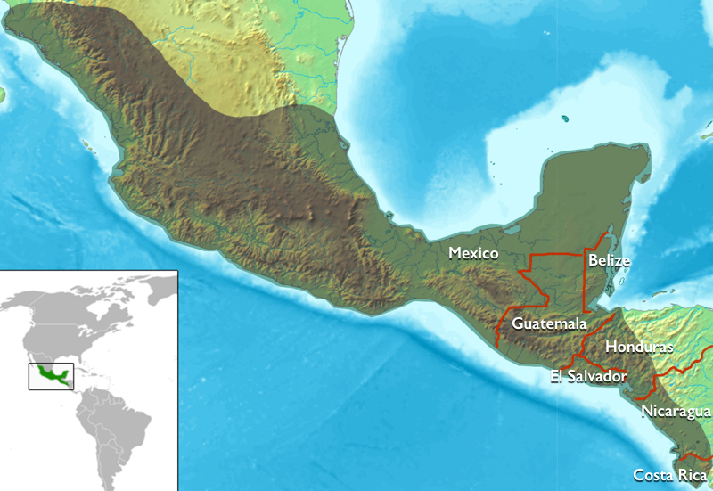
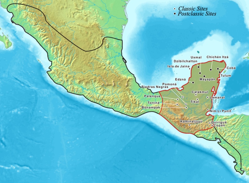
Mesoamerica refers to the diverse civilizations that shared similar cultural characteristics in the geographic areas comprising the modern-day countries of Mexico, Guatemala, Honduras, Belize, El Salvador, Nicaragua, and Costa Rica. Some of the shared cultural traits among Mesoamerican peoples included a complex pantheon of deities, architectural features, a ballgame, the 260-day calendar, trade, food (especially a reliance on maize, beans, and squash), dress, and accoutrements (such as earspools). Some of the most well-known Mesoamerican cultures are the Olmec, Maya, Zapotec, Teotihuacan, Mixtec, and Mexica (or Aztec). The geography of Mesoamerica is incredibly diverse—it includes humid tropical areas, dry deserts, high mountainous terrain, and low coastal plains.
Typically, when we discuss Mesoamerican art, we are referring to art made by peoples in Mexico and much of Central America. When people mention Native North American art, they are usually referring to indigenous peoples in the U.S. and Canada, even though these countries are technically all part of North America. More recently, archaeologists and art historians have considered connections between the Southwestern and Southeastern U.S. and Mesoamerica, an area sometimes called either the Greater Southwest or Greater Mesoamerica. Focusing on these connections demonstrates how people were in contact with one another through trade, shared beliefs, migration, or conflict. Ball courts, for instance, are found in Arizona sites such as the Pueblo Grande of the Hohokam. It is important to remember that modern-day geographic terms—like Mesoamerica or the Southwestern U.S.—are recent designations.
Art historians and archaeologists divide Mesoamerican history into distinct periods and some of these periods are then further divided into the sub-periods—early, middle, and late.
| Period | Dates | Cultures |
|---|---|---|
Archaic Period |
c. 3500 – 1500 B.C.E. | |
| Pre-Classic Period
(or Formative Period) |
c. 1800 B.C.E. – 250 C.E. |
Olmec
Teotihuacan Tiatilco Maya Zapotec |
| Classic Period | c. 150 – 650 C.E | Teotihuacan
Maya |
| Epiclassic Period | c. 650 – 900 C.E | Maya
Toltec |
| Postclassic Period | c. 900 – 1519 C.E. | Toltec
Mexica (Aztec) Mixtec Maya |
The date for the end of the Postclassic period is somewhat contested as it presumes that Mesoamerican culture largely ended with the arrival of Spaniards into the Mexica capital of Tenochtitlan in 1519, though Mesoamerican culture continued under Spanish control, albeit significantly transformed.
You might also encounter the term Pre-Columbian, which is a term designating indigenous cultures prior to the arrival of Columbus. It includes those in Mesoamerica, as well as in South America and the Caribbean. This term is problematic for several reasons and can be further explored here.
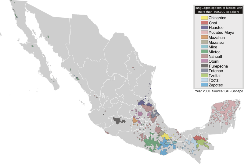
There was no single language that united the peoples of Mesoamerica. Linguists believe that Mesoamericans spoke more than 125 different languages. For instance, Maya peoples did not speak “Mayan”, but could have spoken Yucatec Maya, K’iche, or Tzotzil among many others. The Mexica belonged to the bigger Nahua ethnic group, and therefore spoke Nahuatl.
Mesoamerican writing systems vary by culture. Rebus writing (writing with images) was common among many groups, like the Nahua and Mixtec. Imagine drawing an eye, a heart, and an apple. You’ve just used rebus writing to communicate “I love apples” to anyone familiar with these symbols. Many visual writing systems in Mesoamerica functioned similarly—although the previous example was simplified for the sake of clarity. You might encounter the phrases “writing without words” or “writing with signs” used to describe many writing systems in Mesoamerica. It is also called pictographic, ideographic, or picture writing.
Only the Maya used a writing system like ours, where signs like letters designate sounds and syllables, and combined together to create words. Maya hieroglyphic writing is logographic, which means it uses a sign (think of a picture, symbol, or a letter) to communicate a syllable or a word[1].
Other shared features among Mesoamerican peoples were the 260-day and 365-day calendars. The 260-day calendar was a ritual calendar, with 20 months of 13 days. Based on the sun, the 365-day calendar had 18 months of 20 days, with five “extra” nameless days at the end. It was the count of time used for agriculture.
Imagine both of these calendars as interlocking wheels. Every 52 years they completed a full cycle, and during this time special rituals commemorated the cycle. For example, the Mexica celebrated the New Fire Ceremony as a period of renewal. These cycles were understood as life cycles, and so reflect creation, death, and rebirth. The Maya (especially during the Classic period) also used a Long Count calendar in addition to the two already mentioned (rather than a cyclical calendar, the Long Count marked time as if along an extended line that does not repeat).
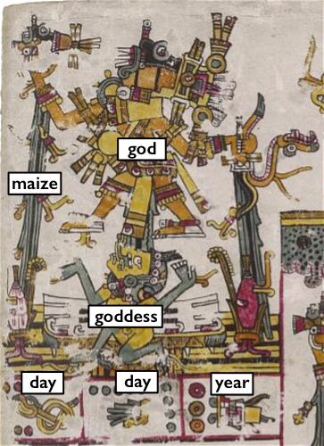
A complex pantheon of gods existed within each Mesoamerican culture. Many groups shared similar deities, although there was a great deal of variation. Deities that had important roles across Mesoamerica included a storm/rain god and a feathered serpent deity. Among the Mexica, this storm/rain god was known as Tlaloc, and the feathered serpent deity was known as Quetzalcoatl. The Maya referred to their storm/rain deity as Chaac (there are multiple spellings). The equivalent of Quetzalcoatl among different Maya groups included Kukulkan (Yucatec Maya) and Q’uq’umatz (K’iche Maya). Cocijo is the Zapotec equivalent of the storm/rain god. Many artworks exist that show these two deities with similar features. The storm/rain deity often has goggle eyes and an upturned mouth/snout. Feathered serpent deities typically showed serpent features paired with feathers.
It is difficult to generalize about Mesoamerican religious beliefs and cosmological ideas because they were so complex. Throughout Mesoamerica, there was a general belief in the universe’s division along two axes: one vertical, the other horizontal. At the center, where these two axes meet, is the axis mundi, or the center (or navel) of the universe. On the horizontal plane, four directions branch off from the axis mundi. Think of the four cardinal directions (north, south, east, and west). On the vertical plane, we generally find the world split into three major realms: the celestial, terrestrial, and underworld.
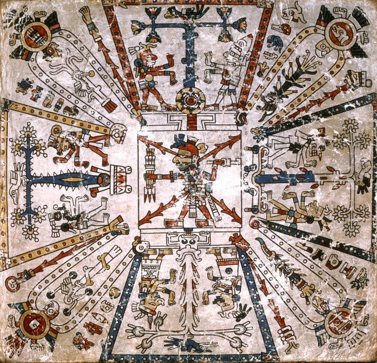
One Mexica example helps to clarify this complex cosmological system. An image in the Codex Féjervary-Mayer displays the cosmos’s horizontal axis. In the center is the deity Xiuhtecuhtli (a fire god), standing in the place of the axis mundi. Four nodes (what look almost like trapezoidal petals) branch off from his position, creating a shape called a Maltese Cross. East (top) is associated with red, south (right) with green, west (bottom) with blue, and north (left) with yellow. A specific plant and bird accompany each world direction: blue tree and quetzal (east), cacao and parrot (south), maize and blue-painted bird (west), and cactus and eagle (north). Two figures flank the plant in each arm of the cross. Together, these figures and Xiuhtecuhtli represent the Nine Lords of the Night. This cosmogram describes how the Mexica conceived of the universe.
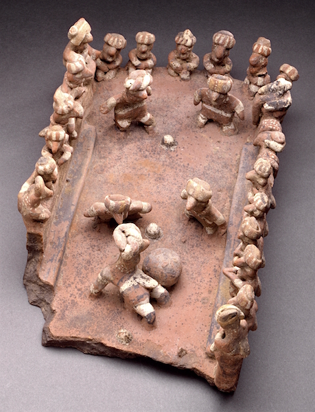
Peoples across Mesoamerica, beginning with the Olmecs, played a ritual sport known as the ballgame. Ballcourts were often located in a city’s sacred precinct, emphasizing the importance of the game. Solid rubber balls were passed between players (no hands allowed!), with the goal of hitting them through markers. Players wore padded garments to protect their bodies from the hard ball.
The meanings of the ballgame were many and varied. It could symbolize a range of larger cosmological ideas, including the movement of the sun through the underworld every night. War captives also played the game against members of a winning city or group, with the game symbolizing their defeat in war. Sometimes a game was even played instead of going to war.
Numerous objects display aspects of the ballgame, attesting to its significant role across Mesoamerica. We have examples of clay sculptures of ballgames occurring on courts. Ballplayers are also frequent subjects in Maya painted ceramic vessels and sculptures. Stone reliefs at El Tajin and Chichen Itza depict different moments of a ballgame culminating in ritual sacrifice. Painted pictorial codices, such as the Codex Borgia, display I-shaped ballcourts, and stone depictions of ballgame clothing have been found. Today, people in Mexico still play a version of the ballgame.
The Mesoamerican ballgame
The Mesoamerican ballgame was a sport with ritual associations played since at least 1650 BCE by the pre-Columbian people of Ancient Mesoamerica. It is known by a wide variety of names. In English, it is often called pok-ta-pok, adapted it from the Yucatec Maya word pokolpok. In Nahuatl, the language of the Aztecs, it was called ōllamaliztli or tlachtli. In Classical Maya, it was known as pitz. In modern Spanish, it is called juego de pelota maya, juego de pelota mesoamericano, or simply pelota maya.
The sport had different versions in different places during the millennia, and a modernized version of the game, ulama, is still played by the indigenous populations in some places.
Mesoamerican societies continue to impress us with their sophistication and accomplishments, notably their artistic achievements. Our understanding continues to expand with ongoing research and archaeological excavations. Recent excavations in Mexico City, for instance, uncovered a new monumental Mexica sculpture buried with some of the most unique objects we’ve ever seen in Mexica art. With these discoveries, our understanding of the Mexica will no doubt grow and change.
The Maya
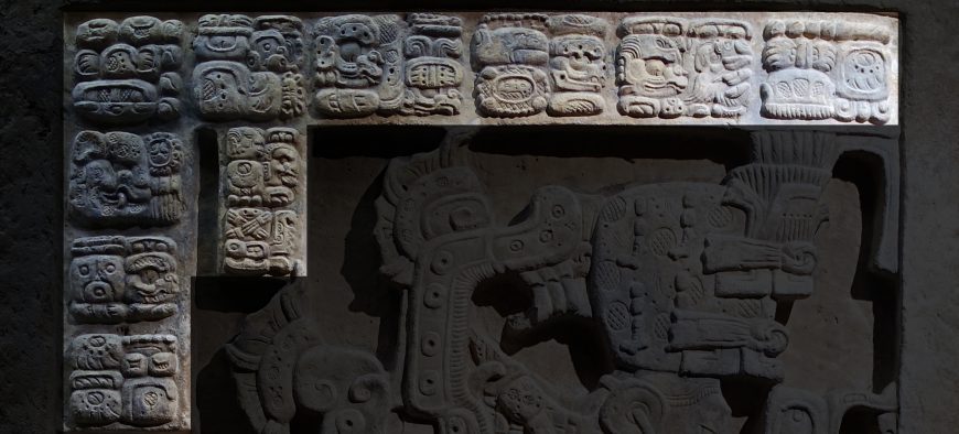
The Maya are a culturally affiliated people that continue to speak their native languages and still often use the ancient 260-day ritual calendar for religious practices. The ancient Maya were united by belief systems, cultural practices that included a distinct architectural style, and a writing system. They were also joined by political interaction in the form of warfare and intermarriage. They left an artistic legacy that ranges from intricately carved monolithic sculptures to complex mural cycles. The ancient Maya are credited with creating the most advanced Mesoamerican writing system, which was logo-syllabic, meaning that it consists of pictorial symbols or glyphs that represent either entire words or syllables. It is the only pre-Hispanic writing system of Mesoamerica that has been largely deciphered.
The Maya are also known for their advanced understanding of time, which they acquired through their study of astronomy and which allowed for the development of a complex calendrical system.
Public inscriptions—which decorated temples and palaces—have also contributed to our knowledge of the Maya, providing archeologists with important dates, names, and ritual information.
During the early Classic Period (c. 250 – 550 C.E.), the Maya had built only a few cities in Mesoamerica. By the Late Classic Period (c. 600 – 900 C.E.) however, the population had grown, and Maya cities had been founded throughout the region. Important Maya cities include Tikal in the east (in what is today Guatemala), Palenque in the west (what is today Mexico), and Copán in the south (in what is today Honduras).
With a population ranging in the millions and scattered throughout a vast region, the Maya were organized into small independent kingdoms or, more accurately, into city states. Each city state was ruled by a divine lord or ajaw/ahau who controlled territory around the capital city and frequently fought with neighboring states for preeminence. Political and economic rivalries among the Maya lords were fueled by an interest in acquiring territory and controlling trade routes—activities made more complicated by the remoteness of many Maya cities as well as their diverse geographies (Maya cities could be found in lowland rainforests and mountainous highlands). Different from the later Aztec, who centralized power and created a true empire, Maya power remained de-centralized and was spread throughout numerous kingdoms.
The collapse of Maya cities in the tenth century is not fully understood but may have resulted from complex factors including climate change (and resulting drought and crop failures), overpopulation, and political unrest. Following this collapse, Maya civilization continued on the northern tip of the Yucatán Peninsula, where Chichen Itza emerged as an important city of the Post-Classic Period. Though the city was abandoned by the thirteenth century, it was the arrival of Hernan Cortés and his Spanish fleet in the early 16th century that marked the end of the Maya civilization.
Mayan Vessel with a Mythological Scene
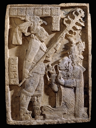
Yaxchilán is located on the south bank of the Usumacinta River, in Chiapas, Mexico. It was a significant Maya center during the Classic period (250-900 C.E.) and a number of its buildings stand to this day. Many of the exteriors had elaborate decorations, but it is the carved stone lintels above their doorways which have made this site famous. These lintels, commissioned by the rulers of the city, provide a lengthy dynastic record in both text and image.
Lintels 24, 25 and 26, set above the three doorways of Structure 23, depict a series of rituals performed by Shield Jaguar II and his wife. Structure 21, commissioned by Bird Jaguar IV, housed lintels 15, 16 and 17. Bird Jaguar was Yaxchilán’s most prolific builder and at least a dozen major structures were initiated or remodeled during his reign.
Lintel 24, considered one of the masterpieces of Maya art, is one of a series of three panels from Structure 23 at Yaxchilán, where it was set above the left (south-east) doorway. The scene represents a bloodletting ritual performed by the king of Yaxchilán, Shield Jaguar the Great (681-742), and his wife, Lady K’ab’al Xook (Itzamnaaj Bahlen III).
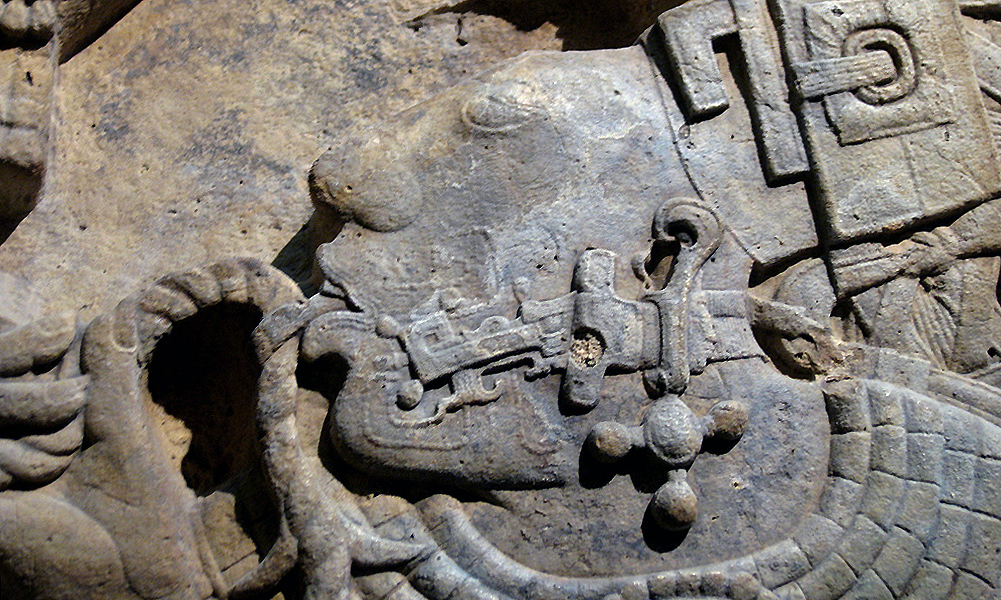
Wearing an exquisitely woven “huipil,” Lady K’abal Xook pulls a thorned rope through her tongue in the principal form of blood sacrifice performed by royal women. The rope falls on to an open codex. Her pierced tongue allowed her blood to flow as part of a ritual communication with gods and spirits. This sacrifice mirrored the Maya story of creation, when the gods let their blood to create the human race. By choosing to take part in the ritual, the queen demonstrated both her moral and physical strength to the people, and her suitability as a Maya royal. Scrolls of blood can be seen around her mouth. She kneels in front of Shield Jaguar who holds a great torch described in the text as a “burning spear” illuminating a ritual that was probably held at night or set in the dark recess of a private chamber.
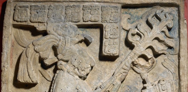
Bloodletting was a common practice in Maya life from the Late Preclassic period (400 B.C.E.- 250 C.E.) onwards, and an essential part of rulership and of all public rituals. The Maya élite drew blood from various parts of their bodies using lancets made of stingray spine, flint, bone or obsidian. These objects are often found in burials and other archaeological contexts, though other perishable materials, like the rope and the bark-paper strips seen on the lintel, are now lost.
The Mexica (Aztec)
During the twelfth century C.E. the Mexica were a small and obscure tribe searching for a new homeland. Eventually they settled in the Valley of Mexico and founded their capital, Tenochtitlan, in 1345. At the beginning of the sixteenth century, it was one of the largest cities in the world.
The Aztec capital city, Tenochtitlan, was founded on a small piece of land in the western part of Lake Texcoco. The city was contained within high mountains and surrounding lake and marshes. To create living and farming space the Aztecs sank piles into the marshes and formed small land masses called chinampas, or floating gardens. Tenochtitlan was highly developed with causeways between islands for transport, aqueducts to carry fresh water and sewers to dispose of waste. The city developed into a metropolis led by a ruling leader and supported by noble classes, priests, warriors and merchants. By the early 1500s it contained an array of pyramids, temples, palaces and marketplaces.
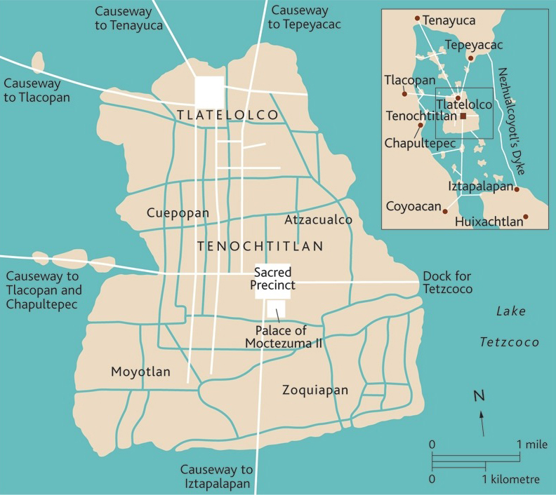
By 1430 C.E. the Mexica had assimilated aspects of the surrounding tribes and developed into a structured society. Their military became powerful, and campaigns were fought and won. The Triple Alliance was created with the lords of Texcoco (situated on the eastern shores of Lake Texococo) and Tlacopan (sometimes referred to as Tacuba, situated on the western shores of Lake Texococo) further strengthening Aztec power.
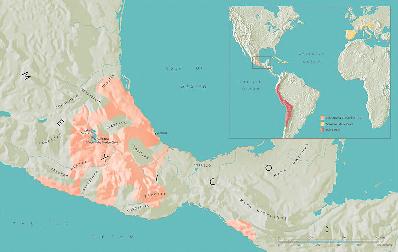
Warfare was extremely important for the Mexica people and led them to conquer most of modern-day central and southern Mexico. They controlled their huge empire through military strength, a long-distance trading network and the tribute which conquered peoples had to pay. The Mexica went to war for two main reasons; to exact tribute and to capture prisoners. They needed prisoners because they believed that the gods must be appeased with human blood and hearts to ensure the sun rose each day. Conquering new regions brought the opportunity to capture slaves who were an important part of Mexica society. Under a succession of rulers armies were sent further across Mexico. By the start of the 1500s the Mexica empire stretched from the Atlantic to the Pacific and into Guatemala and Nicaragua.
The Mexica designed roads for travel by foot because there were no draught animals. These roads were well maintained and boosted trade both for the Mexica and for the tribes under their control. They also enabled the Aztecs to be informed of events across their empire. The Mexica exported luxury items such as jewelry and garments manufactured from imported raw materials. They also exported goods such as lake salt and ceramic goods. Exotic luxuries such as animal skins, feathers, rubber and jade came from the distant southern tropics. Beautiful, manufactured goods such as jewelry, textiles and pottery came from craft centers, a famous example of which is Cholula (in the modern Mexican state of Puebla). Traded goods even came from as far away as southern New Mexico and raw materials from Central America appeared in the markets of Tenochtitlan.
Stone sculpture in the British Museum collection reflects the Mexica’s complex religious beliefs and the large pantheon of gods they worshipped. Their sophisticated ritual calendar reflected the rhythms of the agricultural year and their ceramic sculptures are noted for their visual impact. Musical instruments such as drums were decorated with intricate carvings, probably because of the importance of music during Mexica rituals.
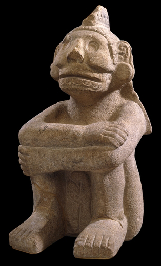
This sculpture represents Mictlantecuhtli, an Aztec god associated with death. It is made from a sandstone which is not found in the Mexican highlands and was probably obtained in Veracruz. The figure bears three glyphs, carved on his back: “Two Skull,” “Five Vulture,” and “Four House.”
Mictlantecuhtli, and his counterpart Mictlancihuatl, inhabited the lowest of the nine levels in which the Underworld (Mictlan) was divided. The “soul” of the deceased went to a particular level in Mictlan according to the circumstances of their death. Those who died of natural causes went to the ninth level and had to negotiate all sorts of obstacles to reach it. To help the “souls” in their dangerous journey the deceased were cremated with some of their possessions, especially the tools they used in life.
Two spectacular ceramic figures of Mictlantecuhtli were recovered in the 1980s from the “House of the Eagles,” a building located in the Sacred Precinct of the Mexica capital, Tenochtitlan. These colossal figures had traces of blood on them. This is consistent with depictions in the codices (screenfold books) of ceremonies in which an image of Mictlantecuhtli, or a person representing him, is bathed with blood.
Craftsmen also worked in gold, turquoise mosaic and feathers. Most pieces were destroyed by the Spanish invaders, but the British Museum holds a number of turquoise mosaics, the most beautiful of which were produced by Mixtec craftsmen and sent to the Mexica as tribute.
Tlaloc Vessel
Mesoamericans made screenfold manuscripts of great artistic beauty. One of them is the Codex Borgia, an Aztec manuscript made during the late Post-Classic period, which stretched from about 1250 until about 1521. It has been studied for centuries, and scholars continue to study this complex manuscript in order to better understand its original meaning and use.
While manuscripts were both ubiquitous and esteemed in Mesoamerica, only twelve survived the destruction related to the conquest of the Aztecs by Spain, when most were burned or otherwise destroyed. Each of the surviving manuscripts bears the name of its European owner or the institution where it was or is now kept. For example, the Codex Borgia is named after its former owner, Cardinal Stefano Borgia, an avid collector of coins and manuscripts.
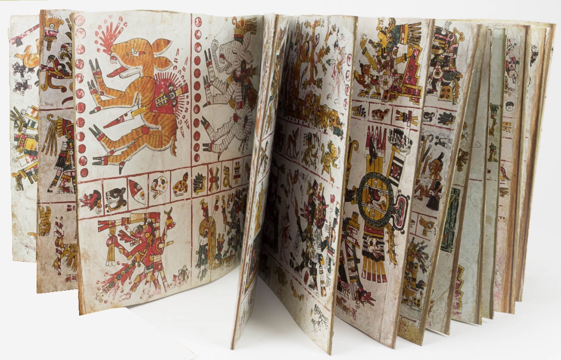
Manufacturing screenfolds involved gluing long strips of leather or paper. These measured different widths but were of approximately the same height to form an even longer strip that was folded back and forth, accordion-like, to make “pages.” Scholars call the screenfold’s front “obverse” and its back “reverse.” Two pages, a large section, or even an entire side—obverse or reverse—can be viewed simultaneously. The screenfold is a Mesoamerican construction, strikingly different from European manuscripts whose pages are bound on the left side so the reader sees two pages at a time. Artists covered the screenfold’s obverse and reverse with white gesso to prepare it for painting.
When completely unfolded, the Codex Borgia measures approximately 1,030 centimeters (more than 33 feet) in width. When folded, its nearly square pages, each measuring approximately 26.5 by 27 centimeters, can be individually appreciated. The screenfold consists of 39 double-sided pages or 78 single pages, though only 76 of these are painted. The two outermost pages served as covers to which wooden panels were attached (only the Codex Vaticanus B retains these panels).
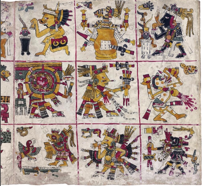
The Codex Borgia features images with precise contour lines and painted with polychrome washes. In its dense imagery, human figures (usually representing gods) predominate, although plants, trees, animals, water, architectural features, celestial bodies, shields, and tools and accoutrements also appear. These are sketched with fine black lines, which in most instances are delicate and precise, such as the outline of the bird’s beak on folio (page) 23. Other outlines are rendered with somewhat thicker strokes, as is visible in the human figure’s legs and the feathers on the bird’s outstretched wings. Sometimes lines are executed as if to evoke shading, such as the narrow blue band at the base of the figure’s headdress. In the bird’s claw, diagonal lines coming from opposite directions simulate texture.
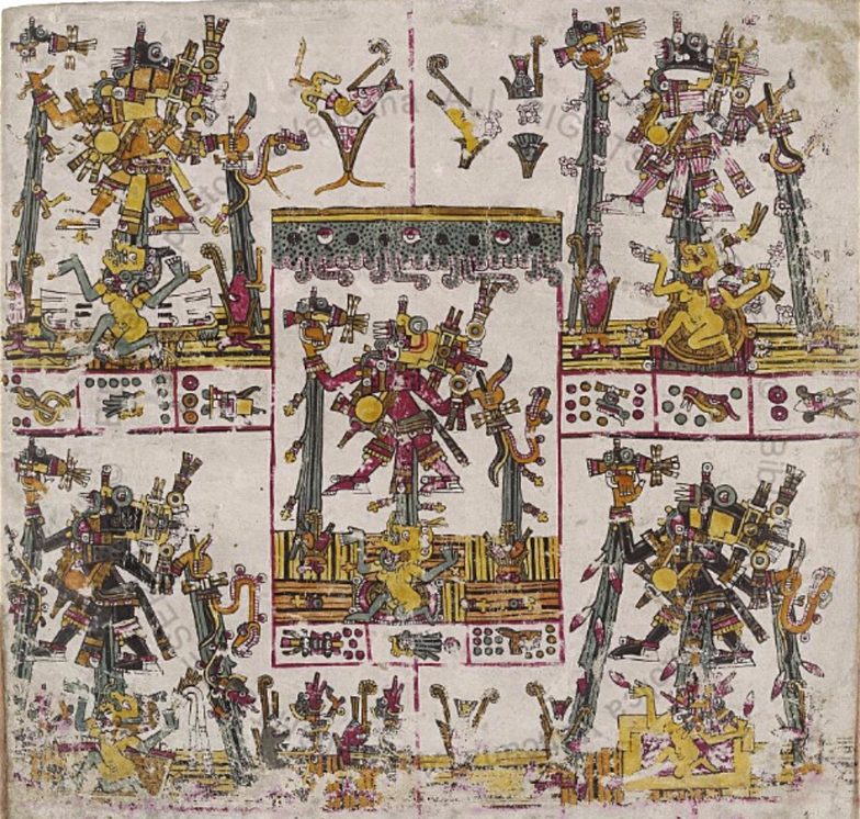
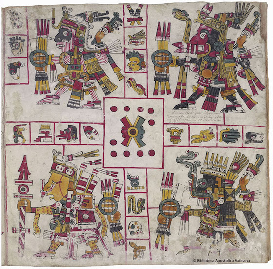
Pre-conquest manuscripts like the Codex Borgia help us to understand indigenous thought before the arrival of Europeans and Africans; however, the writing is extraordinarily difficult to decipher as it consists entirely of images and glyphs (characters or symbols). For example, page 28 features five compartments—one in each corner and one in the center—each with a male hovering above a female.
Each female wears an elaborate headdress but is otherwise naked. The male-female couple appears amid maize, an important Mesoamerican plant. Below each compartment are three rectangles each containing a glyph. How do we decipher these images and glyphs? In the early colonial period, indigenous scribes, friars, conquistadors, and other Spanish officials compiled documents—what we call the ethnohistoric record—including chronicles and manuscripts with illustrations by indigenous artists that featured imagery with explanatory glosses in Spanish, Nahuatl (the language of the Mexica, or Aztecs), Latin, and/or Italian. These help us to understand writing in pre-Columbian manuscripts.
For example, page 28 of the Codex Borgia depicts Tlaloc, the god of rain whose iconography includes goggle eyes and fangs. Tlaloc wears costume elements and paraphernalia of additional creator gods, which, starting in the lower right and following a counterclockwise direction, are: Tezcatlipoca (Smoking Mirror), Tlahuizcalpantecuhtli (Lord of Dawn), Xiuhtlecuhtli (Fire Lord), Quetzalcoatl (Wind God), and Xochipilli (Flower Prince). The ethnohistoric sources also help us to identify the female figures and glyphs. The females wear the headdress of Ehecatl-Quetzalcoatl, the wind god (lower right), Xochiquetzal, the Flower Quetzal (upper right), and Chalchitlucue, the water goddess (the other compartments). The glyphs are day signs recording dates. In each compartment two glyphs represent days, and one represents a year (page 28 records five consecutive years)
It is generally believed that the glyphs record the movements of the planet Venus and other celestial bodies, which would link the iconography of page 28 to astronomy and rainfall patterns. Because some of the glyphs are severely worn, there is some disagreement about exactly what they represent. Overall, the page’s iconography relates to maize, creating what some would call an “agricultural almanac.”
The Codex Borgia’s scholarship is extensive and includes discussions of its materials, construction, style, origin, and interpretation (of specific figures, pages, or sections). In the 1790s, the Jesuit José Lino Fábrega wrote a pioneering commentary arguing that the manuscript relays messages about divination (predicting the future). Eduard Seler’s 1904 page-by-page iconographic analysis of the Codex Borgia, which continues to be an essential tool in the study of Mesoamerican manuscripts, contends that the Codex Borgia conveys messages about both divination and astronomy. Subsequent scholars have shown that the Codex Borgia also records historical, ritual, mythological, and most recently, botanical information. For example, I have argued with iconographic, ethnographic, and scientific evidence that page 28 represents pollination. Because so few original codices survive, the continued study of the Codex Borgia is essential for our understanding of the pre-conquest cultures of the Americas.
South America
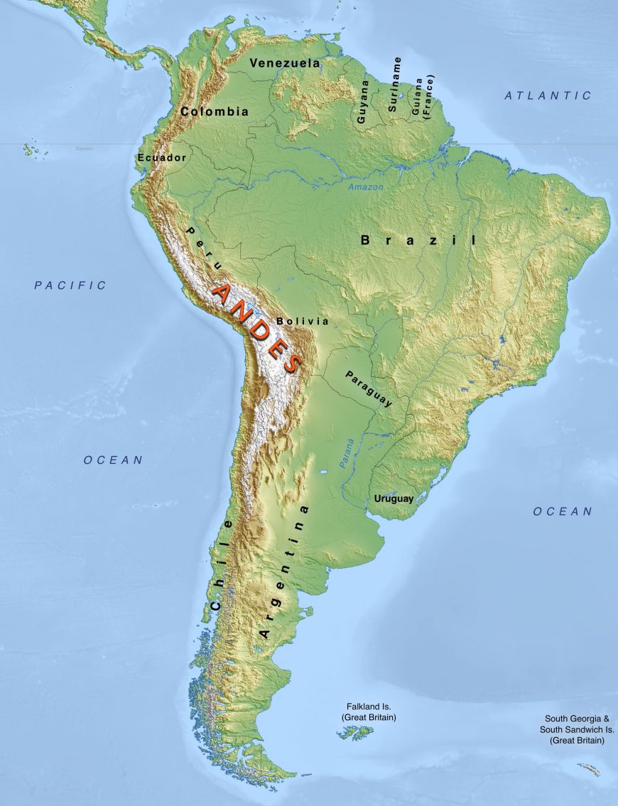
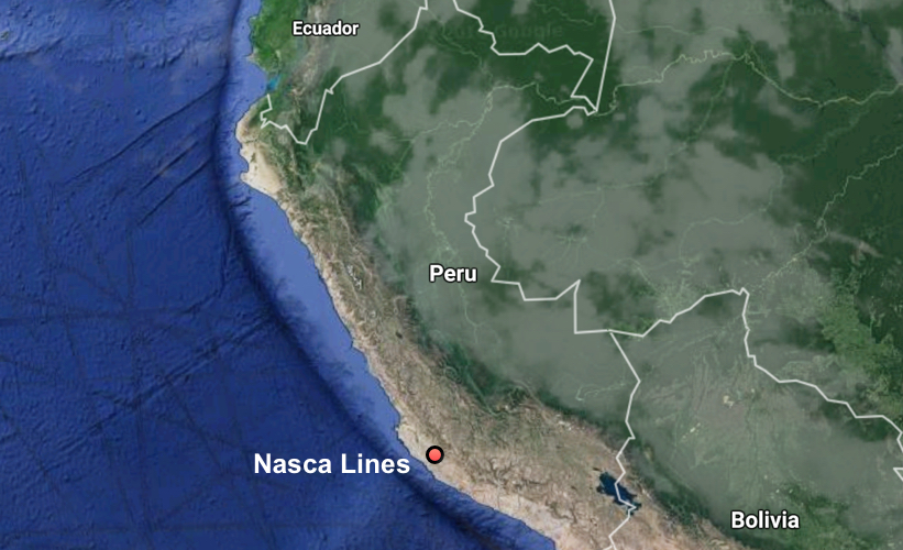
The Andes region encompasses the expansive mountain chain that runs nearly 4,500 miles north to south, covering parts of modern-day Venezuela, Colombia, Ecuador, Peru, Bolivia, Chile, and Argentina. The pre-Columbian inhabitants of the Andes developed a stunning visual tradition that lasted over 10,000 years before the Spanish invasion of South America in 1532.
One of the most ecologically diverse places in the world, the Andes mountains give way to arid coastlines, fertile mountain valleys, frozen highland peaks that reach as high as 22,000 feet above sea level, and tropical rainforests. These disparate geographical and ecological regions were unified by complex trade networks grounded in reciprocity.
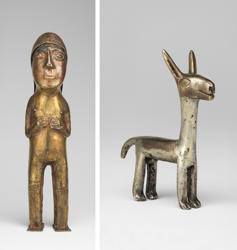
The Andes was home to thousands of cultural groups that spoke different languages and dialects, and who ranged from nomadic hunter-gatherers to sedentary farmers. As such, the artistic traditions of the Andes are highly varied. Artists crafted objects of both aesthetic and utilitarian purposes from ceramic, stone, wood, bone, gourds, feathers, and cloth. Pre-Columbian Andean peoples developed a broad stylistic vocabulary that rivaled that of other ancient civilizations in both diversity and scope. From the breathtaking naturalism of Moche anthropomorphic ceramics and jewelry to the geometric abstraction found in Inka textiles, Andean art was anything but static or homogeneous.
Gender and power, the Moche tomb of Señora de Cao
While Andean art is perhaps most notable for its diversity, it also possesses many unifying characteristics. Andean artists across the South American continent often endowed their works with a life force or sense of divinity. This translated into a process-oriented artistic practice that privileged an object’s inner substance over its appearance.
Andean art is also characterized by its environmental specificity; pre-Columbian art and architecture was intimately tied to the natural environment. Textiles produced by the Paracas culture, for instance, contained vivid depictions of local birds that could be found throughout the desert peninsula.
The nearby Nazca culture is best known for its monumental earthworks in the shape of various aquatic and terrestrial animals that may have served as pilgrimage routes. The Inkas, on the other hand, produced windowed monuments whose vistas highlighted elements of the adjacent sacred landscape. Andean artists referenced, invoked, imitated, and highlighted the natural environment, using materials acquired both locally and through long-distance trade. Andean objects, images, and monuments also commanded human interaction.
Pre-Columbian Andean art was meant to be touched, worn, held, maneuvered, or ritually burned. Elaborately decorated ceramic pots would have been used for storing food and drink for the living or as grave goods to accompany the deceased into the afterlife. Textiles painstakingly embroidered or woven with intricate designs would have been worn by the living, wrapped around mummies, or burned as sacrifices to the gods. Decorative objects made from copper, silver, or gold adorned the bodies of rulers and elites. In other words, Andean art often possessed both an aesthetic and a functional component — the concept of “art for art’s sake” had little applicability in the pre-Columbian Andes. This is not to imply that art was not appreciated for its beauty, but rather that the process of experiencing art went beyond merely viewing it.
At the same time that Andean art commanded human interaction, it also resonated with the supernatural realm. Some works were never seen or used by the living. Mortuary art, for instance, was essentially created only to be buried in the ground.
The magnificent ceramics and metalwork found at the grave of the Lord of Sipán on Peru’s north coast required a tremendous output of labor yet were never intended for living beings. The notion of “hidden” art was a convention found throughout the pre-Columbian world. In Mesoamerica, for instance, burying objects in ritual caches to venerate the earth gods was practiced from the Olmec to the Aztec civilizations.
Works of art associated with particular rituals, on the other hand, were often burned or broken in order to “release” the object’s spiritual essence. Earthworks and architectural complexes best viewed from high above would have only been “seen” from the privileged vantage point of supernatural beings. Indeed, it is only with the advent of modern technology such as aerial photography and Google Earth that we are able to view earthworks such as the Nazca lines from a “supernatural” perspective.
Art was often conceived within a dualistic context, produced for both human and divine audiences. The pre-Columbian Andean artistic traditions covered here comprise only a sampling of South America’s rich visual heritage. Nevertheless, it will provide readers with a broad understanding of the major cultures, monuments, and artworks of the Andes as well as the principal themes and critical issues associated with them.
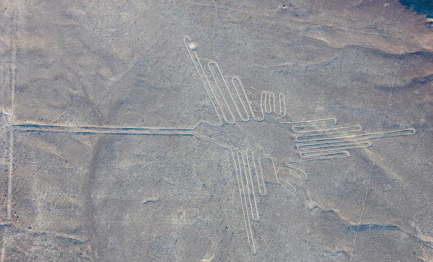
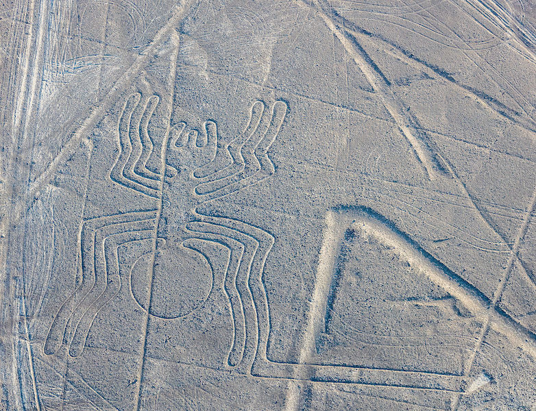
Nasca Geoglyphs
Located in the desert on the South Coast of Peru, the Nasca Geoglyphs are among the world’s largest drawings. Also referred to as the Nasca Lines, they are more accurately called geoglyphs, which are designs formed on the earth. Geoglyphs are usually constructed from strong natural material, such as stone, and are notably large in scale.
Imagine encountering such a drawing. The hummingbird measures over 300 feet in length and is one of the most famous Nasca Geoglyphs. Among the other celebrated geoglyphs of mammals, birds and insects are a monkey, killer whale, spider, and condor. Various plants, geometric shapes, abstract patterns, and intersecting lines fill the desert plain, known as the Pampa, an area covering approximately 200 square miles near the foothills of the Andes. The zoomorphic geoglyphs are the oldest and most esteemed. Each appears to have been made with a single continuous line.
Today it is believed that the geoglyphs were created by the Nasca people, whose culture flourished in Peru sometime between 1-700 C.E. They inhabited the river valleys of the Rio Grande de Nasca and the Ica Valley in the southern region of Peru, where they were able to farm, despite the desert environment—one of the driest regions in the world. The high Andes Mountains to the east prevent moisture from the Amazon from reaching the coast, so there is very little rainfall; water that does arrive, comes from mountain runoff.
Since the Nasca geoglyphs are so large, it seems clear they were constructed by organized groups of people and that no single artist made them. The construction of the geoglyphs is thought to represent organized labor where a small group of individuals directed the design and creation of the lines, a process that may have strengthened the social unity of the community. Despite the impressive scale of the geoglyphs, these remarkable works did not require complex technology. Most geoglyphs were formed by removing weathered stones from the desert floor, stones that had developed a dark patina known as “desert varnish” on their surface. Once removed, the lighter stones below became visible, forming the famous Nasca Lines. The extracted darker stones were placed at the edges of the lines, forming a border that accented the lighter lines within. Straight lines could be created by extending cords, one on each side of the line, between two wooden stakes (some of which have been recovered) that guided workers and allowed for the creation of sight lines.
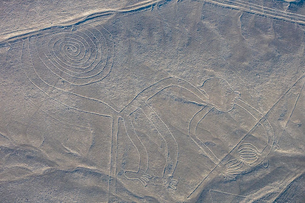
For larger geometric shapes, such as trapezoids, borders were marked and then all the stones on the interior were removed and placed along edges or heaped in piles at the edges of the geoglyph. Broken pottery has been found mixed with the piles of stones. Spirals and animal shapes were made in a similar manner. Spirals, for example, would be formed by releasing slack in a cord as workers moved around in a circular path, moving further and further from the center where the spiraling line begins. For animal forms, such as monkeys, whales, or hummingbirds, portions of the figures might be made in the same manner as the spiral in the monkey’s tail, or the image might be based on a gridded drawing or textile model that was enlarged on the desert floor where lines were staked out to create the figure.
The oldest of the Nasca Geoglyphs is more than 2000 years of old, but, as a group, the Nasca geoglyphs were created over several centuries, with some later lines or shapes intersecting or overlapping with previously created lines. This is just one of the unusual features of these geoglyphs. Even more curious, the drawings are best observed from the air, which is why they did not become widely known until the 1920s after the development of flight. Although it is possible to observe some of the lines from the adjacent Andean foothills or the modern mirador (viewing platform), the best way to see the lines today remains a flight in a small plane over the Pampa (lowlands). These amazing images are so large that they cannot be truly appreciated from the ground. This, of course, raises the question: for whom were the lines made? And, what was their purpose?
Archaeologists are not certain of the purpose of the lines, or even of the audience for whom the lines were intended since they can only be seen clearly from the air (This is now particularly true of the older animal designs). Were they made to be seen by deities looking down from the heavens or from distant mountain tops? Perhaps the numerous theories that have been proposed will eventually be clarified as our understanding of the cultures of ancient Peru increases.
Shortly after the geoglyphs were first investigated, researchers sought an astronomical interpretation, suggesting that the geoglyphs might be aligned with the heavens, and perhaps represented constellations or marked the solstices or planetary trajectories. While some geoglyphs seem connected to celestial events, such as marking the summer solstice (in December) when mountain waters flow to the coast, it is difficult to find celestial alignments for most of the geoglyphs. As far as we know, Andean peoples did not form pictures by connecting the stars in the night sky as we do; rather they looked at the black spaces between stars and saw shapes that they converted into their own reverse “constellations.” It is important to note that these constellations do not seem to match the Nasca geoglyphs.
Many other reasonable theories have been proposed. Some scholars have suggested that the geoglyphs represent Nasca deities, or formed a calendar for farming, or represented ceremonial walkways. Because some of the lines do seem to direct people to Cahuachi, a Nasca religious center and pilgrimage destination, it seems possible that ancient Nasca people walked the lines. It is also possible that Nasca people ritually danced on the lines, perhaps in connection with shamanism and the use of hallucinogens. The geoglyphs, particularly the early animals which are clearly spaced apart from each other, may also have strengthened group identity and reinforced social interaction patterns as individual groups of people may each have tended or “owned” one of the geoglyphs.
Because the Nasca Geoglyphs were made directly on the earth by rearranging stones on the desert floor, these giant images are actually quite vulnerable to damage. In time the lighter-colored stones exposed by the Nasca people may attain their own patina, making them less visible, but the designs face greater threats from vehicle and pedestrian traffic. Crossing the lines can damage their borders and make the images less distinct. Because of this, the Peruvian government has created a mirador (viewing platform) along the Pan American Highway where visitors can climb to view a few drawings without damaging the lines.
In the end, it is likely that the Nasca Geoglyphs served more than one purpose, and these purposes may have changed over the centuries, especially given that new lines often “erased” older ones by “drawing” over them. It does appear that many geoglyphs made reference to water and agricultural fertility and were used to promote the welfare of the Nasca people. The geoglyphs were also a place where people gathered, perhaps for pilgrimage, perhaps to walk or dance on the lines in a ritual pattern. As a gathering place, the Nasca geoglyphs may additionally have turned the Pampa into a map of social divisions, where different families or clans tended different geoglyphs. Although we do not know exact details, we can surmise that the geoglyphs represent a community investment meant to serve this ancient people.
Paracas Textiles

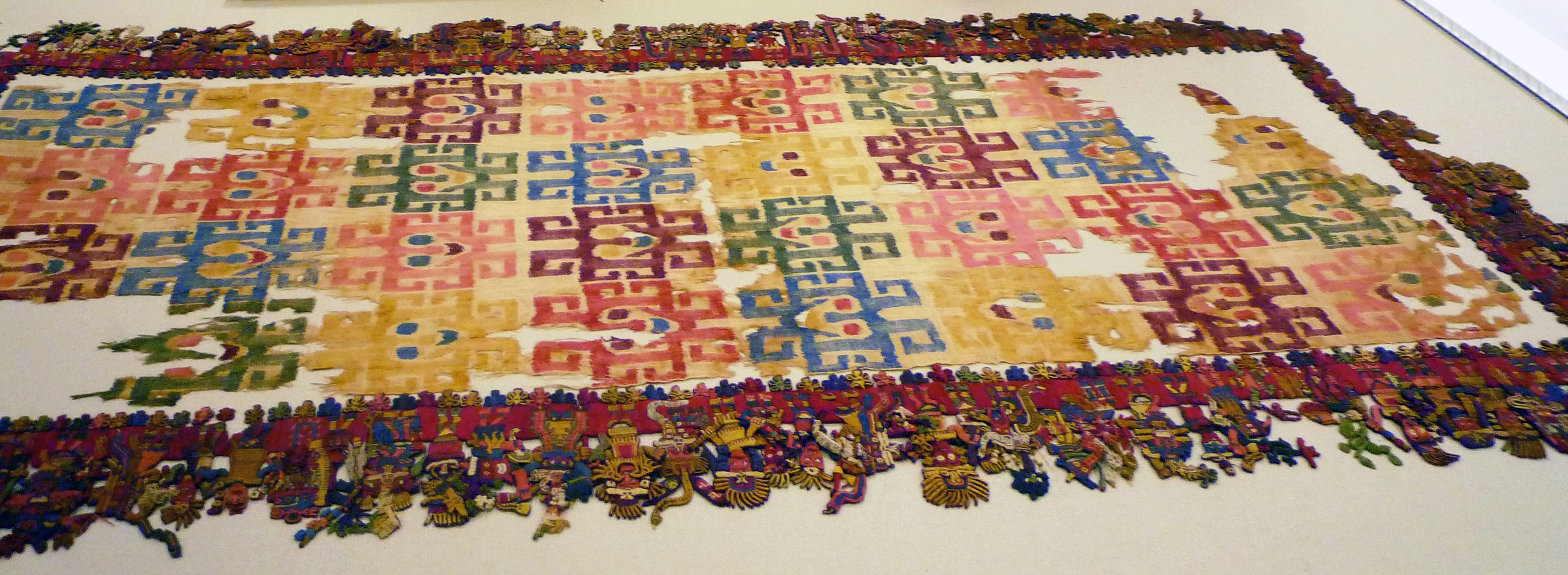
One of the most extraordinary masterpieces of the pre-Columbian Americas is a nearly 2,000-year-old cloth from the South Coast of Peru, which has been in the collection of the Brooklyn Museum of Art since 1938. Despite the textile’s small size (it measures about two by five feet), it contains a vast amount of information about the people who lived in ancient Peru; and despite its great age and delicacy, its colors are brilliant, and tiny details amazingly intact. This is due to the arid environment of southern Peru along the Pacific shore, where it is so dry that organic material buried in the sand remains well preserved for hundreds or even thousands of years.
In the ancient cemeteries on the Paracas Peninsula, the dead were wrapped in layers of cloth and clothing into “mummy bundles.” The largest and richest mummy bundles contained hundreds of brightly embroidered textiles, feathered costumes, and fine jewelry, interspersed with food offerings, such as beans. Early reports claimed that this cloth came from the Paracas peninsula, so it was called “THE Paracas textile,” to mark its excellence and uniqueness. Currently, scholars have revised this provenance, and now attribute the cloth to the related, but slightly later Nasca culture.

Like some other very fine cloths, the Brooklyn textile is finished so carefully on both sides that it is almost impossible to distinguish which is the correct side. Although the central cloth and its framing dimensional border are created by different techniques, both display perfect reversibility—except for three border figures. These three—instead of being duplicated on the back (as if flipped in mirror image), like all the others—appear in back view on one side of the cloth, thereby designating a “front” and “back” to the textile.
The central cloth’s design of 32 geometric faces is created by “warp-wrapping,” a technique in which colored fleece is wound around sections of cotton warp threads before weaving. Because the central cloth and the border have different color palettes, they may have been created at different times. The triple-layer border has colorful outer veneers of wool “crossed-looping” that envelop inner cotton cores of looping or weaving. “Crossed-looping” resembles knitting (but is accomplished with a single needle); in areas where the threads are broken, it is possible to glimpse the underlying cotton substrates. While the cotton is off-white, the wool is dyed in jewel-bright tones. The combination of materials suggests extensive trading relationships: for while cotton was grown in coastal valleys, wool came from camelids (such as the llama, alpaca, and vicuña) that live at high altitudes in the Andes mountains.

On the border, a parade of 90 figures is linked together on their lower bodies, which are worked two-dimensionally against a red background. Each figure’s upper body and head is constructed as a separate unit and attached to the woven strip. The upper bodies are worked in bas-relief, with some parts projecting outwards from the plane of the fabric. Tiny components (like leaves and feathers) were worked as separate pieces and then attached, giving a wonderful three-dimensionality and liveliness to the figures, especially because they mingle and overlap.
The parade is arranged in four, single-file, L-shaped lines that proceed around each corner of the cloth. A wide variety of types appear, including human, animal, and monstrous hybrids. Some figures are unique, others are twins, triplets, or even sextuplets; a few are in related groups. Most of the animals and plants that appear can be tied to species still found on the South Coast, and many human figures wear or carry items that directly relate to the archaeological record.
Their jewelry, for example, corresponds to specimens formed from thin sheets of gleaming gold. These include: “forehead ornaments” (shaped like a bird with outstretched wings); “hair spangles” (disk or star shapes that dangle from the wingtips of the forehead ornament); slender, feather-shaped headdress “plumes;” and “mouthmasks.” Mouthmasks hung from the nose septum, and had flaring extensions, like cat whiskers.

The border figures’ clothing also matches examples found archaeologically, and some bear minuscule designs that faithfully represent embroidered decorations found on life-sized garments. Some wear wrap-around dresses of a style worn by women in ancient times; others wear two-part outfits, associated with men. The largest and most beautifully decorated garments were mantles that draped over the shoulders and fell to the knee. By examining stitches on actual mantles, archaeologists have determined that teams of artists worked on them, sitting side-by-side.
Other border details, rather than realistic, seem to be fantastic or mythological. The severed heads (sometimes called “trophy heads”) brandished by some figures, for example, sometimes sprout flourishing plants—as if to suggest themes of sacrifice and fertility. And snake-like streamers that flow from some figures do not correspond to any known object and may indicate supernatural qualities.
When they depicted clothing, Paracas and Nazca artists often added a face, or an animal body to the loose ends of fabric hanging behind a wearer. This artistic convention seems to suggest the lively movements of cloth fluttering behind a wearer, and hints that these ancient people considered cloth a precious carrier of vitality: an interpretation that seems warranted because this vibrant textile gives us such an evocative and animated glimpse into their world.
The Inka
The Inka, like the Mexica of Mesoamerica, were relative newcomers to power at the time of European contact. When Francisco Pizarro took the Inka ruler (or Sapa Inka) Atahualpa hostage in 1532, the Inka empire had existed fewer than two centuries. Also like the Aztecs, the Inka had developed a complex culture deeply rooted in the traditions that came before them. Their textiles, ceramics, metal- and woodwork, and architecture all reflect the materials, environment, and cultural traditions of the Andes, as well as the power and ambitions of the Inka empire.
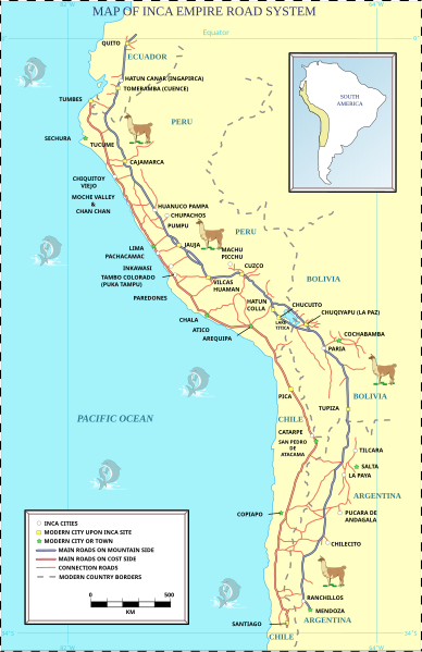
The Inka empire at its greatest extent sprawled from the modern-day city of Quito in Ecuador to Santiago in Chile. The Inka called their empire Tawantinsuyu, usually translated as “Land of the Four Quarters” in their language, Quechua. At the center of the empire was the capital city of Cusco. The empire was connected by a road system—the Qhapaq Ñan—that was used for official Inka business only. Soldiers, officials, and llama caravans carrying food, ceramics, textiles, and other items used the roads, and so did message runners. These runners were stationed at regular intervals along the roads, so that messages could travel swiftly throughout the empire.
However, the messages that these runners carried were not written in the way we would expect. They were not made of marks on paper, stone, or clay. They were, instead, encoded into a knotted string implement called a quipu. Our knowledge of quipu remains limited. We have been able to determine only some of the ways that the quipu were used. Researchers continue to investigate this unique system of communication. The knots along the various cords recorded numbers, so that a knot with 5 loops could represent the number 5. The position on the cord could then determine what the number meant in a decimal system, so that a 5-loop knot could represent the number 5, or 50, or 500, and so forth.
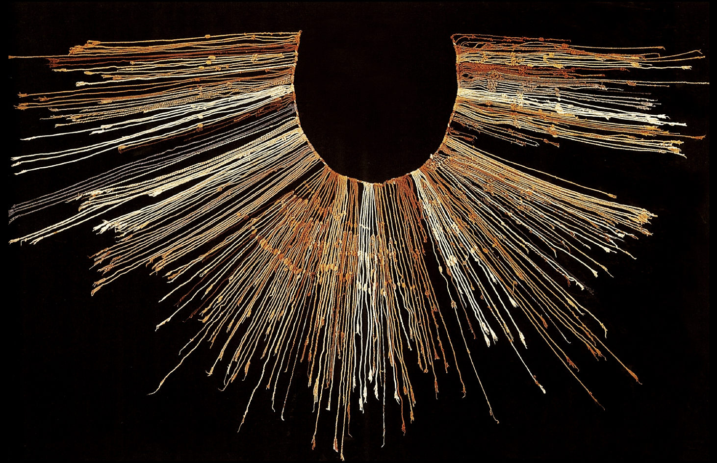
The cords of quipus are frequently composed of different natural and dyed colors, but the reason or meaning behind those colors so far eludes scholars. The numbers encoded in the quipus helped the Inka keep track of the tax-paying obligations of their subjects, record population numbers, harvest yields, herds of livestock, and other important information. Also recorded on the quipu were stories—histories of the Inka and other social information. However, scholars today still don’t know how that information was encoded into the quipu.
Quipus and other Inka fiber objects were made from yarn spun from alpaca fibers. Llamas and alpacas are the domesticated relatives of the wild camelids of the Andes, the guanaco and vicuña, and all of them are related to the camel. Alpacas and llamas were important to the functioning of the Inka empire, but they had been essential to the lives of Andeans for millennia. Llamas provided meat as well as acting as beasts of burden—an adult male llama can carry up to 100 pounds. Alpacas provided soft, strong wool for textiles and ropemaking.
Dressing the empire: Inka warrior tunics

When the Spaniards encountered the Inka, they were confused by the fact that they considered textiles more valuable than gold. Textiles were integral to the structure of the Inka empire. Acllas, or “chosen women,” were kept in seclusion by the Inka to weave fine textiles (called qompi). These textiles mostly took the form of tunics and mantles. Some were distributed as high-status gifts by the Sapa Inka to cement the loyalty of local lords throughout the empire. Others were burned as sacrifices to Inti, the sun god and divine ancestor of the Inka ruling class. This shows us just how highly the Inka regarded textiles: they were fit for a god.
The acllas were not the only ones who wove. People of all ages spun, dyed, and wove textiles. The quality of wool, the fineness of its spinning, the relative rarity of the dye, and the skill of its weaving all determined the value of a textile. Some kinds of textiles were reserved for nobility or for warriors. The super-fine wool of wild guanacos and vicuñas was reserved only for the Sapa Inka’s garments.
Despite the value they placed on textiles, the Inka did also create works out of gold and silver, but unfortunately, most were melted down by the Spaniards for ease of transport or destroyed because they were thought to be idols. Depictions of people, animals, and plants have survived. The plants tend to be quite naturalistic, while the people and animals are more abstracted. Human figures would likely originally have been dressed in miniature clothing. Figurines uncovered at the sites of human sacrifices on remote mountain peaks have been found dressed in finely woven textiles with elaborate feather headdresses.
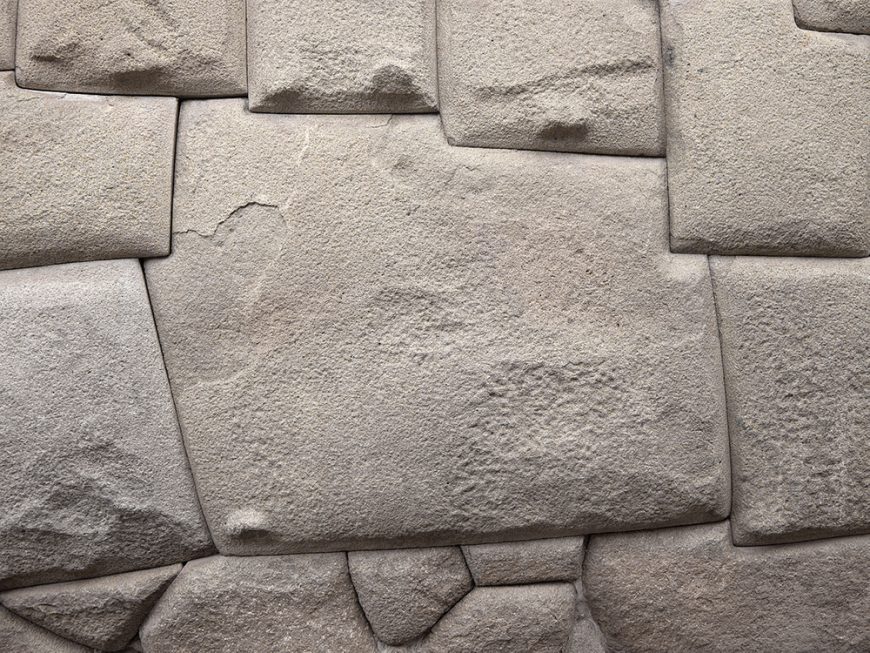
Perhaps the most well-known Inka art is their architecture. The Inka built everywhere they conquered, and their architectural style helped mark areas as belonging to the empire. Inka architecture is based on stone walls, fitted together in a very distinctive way. Instead of cutting stones into blocks and then laying those blocks together in rows, in some cases, the Inka would fit individual stones of varying sizes and shapes against each other, fitting them together like a puzzle. The stones would fit so closely that the Spanish remarked that a person could not even insert a knife blade between them. Each stone was shaped so that it had a slight bulge or a slight indentation on the side where it would lay against another block. These bulges and indentations would slot together, holding the stones in place. It also allowed the stones to shift if they needed to—and they did need to, because Peru is seismically active and has frequent earthquakes.
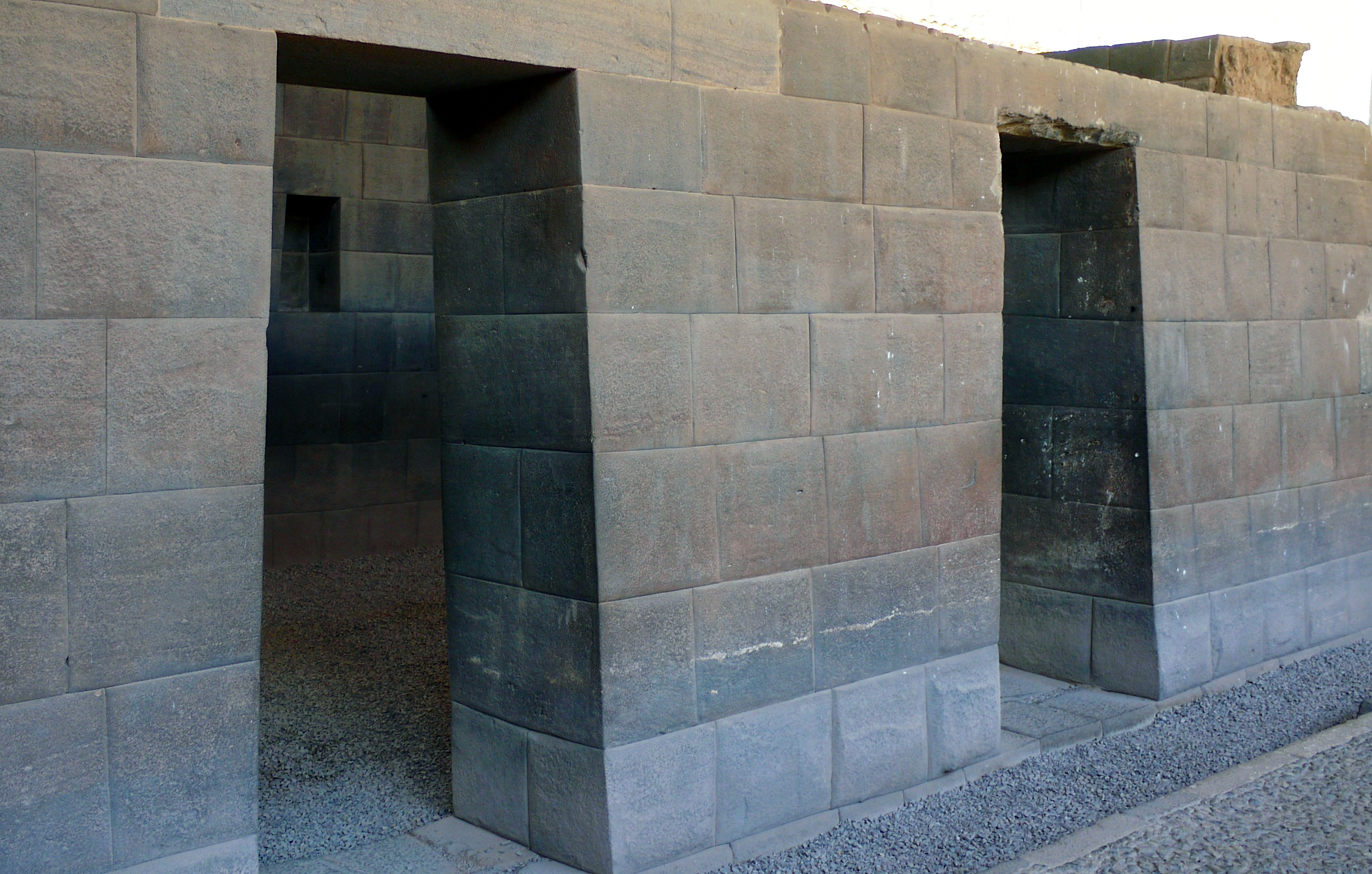
The doorways, windows, and niches placed in Inka walls have a signature vertical trapezoid shape, a recognizable and distinctive aspect of their architecture. Sometimes referred to as a keyhole shape, it is thought that this form is also something that helps stabilize the architecture during earthquakes. The roofs of these buildings were made of wood and thatch.
- Unlike ideographs, these are specific to a language system. The image of a frog to us today might only mean "frog", but in Egyptian hieroglyphs it could be used as the word "qrr" (say it out loud, it's a frog croaking), meaning 'frog', a symbol that identifies the fertility goddess Heket, or the word for "(cyclically) repeating life". A hippopotamus could mean "db" (hippo) or be placed at the end of a word to denote that something is heavy. ↵
the use of existing symbols, such as pictograms, purely for their sounds regardless of their meaning, to represent new words. Many ancient writing systems used what we now term 'the rebus principle' to represent abstract words, which otherwise would be hard to represent with pictograms.
a written character that represents a word or morpheme.
the historical ancestor of the modern book. Instead of being composed of sheets of paper, it used sheets of vellum, papyrus, or other materials. The term codex is often used for ancient manuscript books, with handwritten contents. Some codices, particularly Mayan and Aztec, are long sheets of paper or animal skin folded into pages.
the ritualized self-cutting or piercing of an individual's body that serves a number of ideological and cultural functions.
an ancient Inca device for recording information, consisting of variously colored threads knotted in different ways.
